











With so many free resources on the web, any fee-based solution must offer serious added value. And thats exactly the rub with a critical review of the different options: One pilots added value is another pilots useless frill. All of these products do everything you need, but one might fit your style better than the others. To help you find your match, we looked closely where flight planning can really shine: optimizing a route for winds and fuel stops, accessing the most current airport information and printing a wad of information to toss into your flight bag.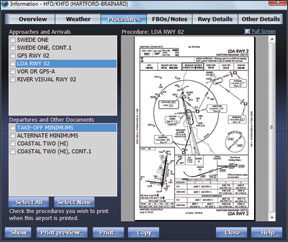
Golden Eagle Plus
Flight Prep Golden Eagle Plus wins our prize for all hitting all the important items without any frills. Its also relatively intuitive to use. Golden Eagle Plus is an enhanced version of the free Golden Eagle software. The upgrade adds scanned charts, approach plates and airport information from NavInfo.com and Flight Guide, by subscription of course.
The window layout is utilitarian, as is much of the data presentation. For example, METARs are displayed on the map with color coding for a quick view of whats going on but the pop-up details are on a single line of text. While were on the topic, automation of weather was a weak point for Golden Eagle Plus. TAFs cant be shown on the map. NEXRAD can be displayed, but its not downloaded automatically. You must get the data by connecting with DUATS. There’s no display of weather over time as with Enflight, Flightsoft or Voyager.
But manual control isn’t all bad. Select the Compare Altitudes function and you’ll see a simple table with altitudes and total times for your route. Pick the one you like best and the nav log, chart and profile view update. There are also hidden powers that take some manual reading, but work well. The “plain language router” is probably misnamed; a command “KHIO NOONS *V-7000 KRBL” isn’t exactly vernacular, but it will plan a flight from Hills-boro to Red Bluff via the NOONS intersection then airways but no higher than 7000 feet. The same can be accomplished more intuitively by other software, but not so quickly.
The approach plate viewer for Golden Eagle Plus is simple but effective. Departure procedures appear with approaches, something thats overlooked on many planners. Golden Eagle Plus can export the nav log, plates and charts (scanned or its own maps) to a PDF trip kit. This ets you take as a file or print