With flight service stations as scarce as hens teeth and a computer on nearly every pilots desk, delivery of pre-flight weather information has been revolutionized over the past five years.
There’s lots of free online information out there, but there’s also a burgeoning industry in subscription weather service sites that purport to provide more and better data than you can otherwise get.
Are they worth it? Or is this just another rat-hole down which you can pour money better squirreled away for an overhaul reserve? We evaluated six pay-for-use pilot weather sites and our conclusion is that none of them are must-haves.
The Lay of the Land
Most of the pay sites have both huge volumes of text and graphical weather information available. Typically, the subscriber can call up METARs and TAFs by airport or by state, TWEB forecasts, look at pireps and examine area forecasts. Some provide NOTAMs and all but one has a route template that spits out some form of a route briefing.
All have radar, surface observation, weather depiction and satellite charts. Some go we’ll beyond those basics with an inventory of graphics. Although there are differences in chart format, most are easily understandable, albeit requiring a bit of interest and experience to translate whats depicted into a go/no-go or routing decision.
Most of the purveyors are good about having the current weather available as soon as its available. There are, however, a few cases in which we found surface observations hours out of date being displayed as current. Caveat emptor.
Much of the information provided by the pay services is available elsewhere on the Web for free. The problem is knowing where to find it, keeping the various URLs current and assembling a coherent self-briefing while flipping between the sites. Youre paying for organization, not exclusivity.
Pay sites can provide more timely radar information (five minutes instead of 30-minute updates), but for most users, this isn’t of critical importance. The true value of the pay services is amassing all or most of the data and graphics you’ll want in one place.
DTNs Aviation Service
DTN (Data Transmission Network Corp.) offers a deal to AOPA members to subscribe to DTNs aviation weather service for $10/month, which compares to the usual $105/month fee for full-up subscribers. Still, the $10 monthly fee is higher than most of the other pay services. As most GA pilots belong to AOPA, access to the special pricing should be nearly universal. To get this offer, enter through the weather page of the AOPA members-only web site (www.aopa.org).
The DTN user can customize a page which appears on the main menu after logging in so that local radar, AIRMETs and the like can be brought up without having to sift through the submenus. Whats missing from this customized page, however, is the ability to select a collection of key METARs and TAFs for easy recall.
For that, you must use a separate request form and either type in up to 12 weather-reporting identifiers (theyve gotta be of the four-letter variety) or pick a state/province to get a group of reports or forecasts. Although the extra steps arent arduous, having to go through the process of filling out a separate request for home-field weather each time is cumbersome.
We had some problems with DTNs service. Repeatedly, current METARs were unavailable more than 15 minutes after the hour despite their being on-line through the NWS. And, on more than one occasion, DTNs METARs for several locations were hours out of date (over five hours old, in one case). This problem is sporadic but it pays to check the date/time block in each METAR to be sure that you know what youre looking at. DTN is unique among the pay providers in not having a route briefing function, or in providing any decoded aviation weather. All of the text weather is in standard (some would say incomprehensible) NWS code. If you want the decode option, DTN isn’t your service.
The absence of the route function means that you have to manually input identifiers for stations along your route in order to retrieve the METARs or TAFs, pull the winds aloft forecasts separately and do without NOTAM information altogether. (DTN has no NOTAMs).
The FD retrieval is more difficult than it need be, too, because you access the wind forecasts by region and within each region there are dozens of station forecasts that arent in alphabetical order, by station or state, making hunting through the list a chore. A computer service should do better.
The graphics that you do get on DTN are good, from the basic surface analysis charts through charts of weather depiction, temps and dewpoint, forecasts for the surface and winds aloft, and prog charts for 12 and 24 hours hence. The download speeds are fast using a 56K modem over standard phone lines, with very few snags.
Flightbrief /Weatherconcepts
Siblings to the DTN service are the Flightbrief and Weatherconcepts sites (www.flightbrief.com and www.weatherconcepts.com). Both have been bought by DTN and both were in the throes of Y2K upgrades during our evaluation in December, which disrupted some of the products. While these appear to be separate sites and have separate pricing schemes, a subscriber who logs on to Flightbrief is taken immediately to the Weatherconcepts main page.
On the subject of pricing, the relationship between these two services is confusing. Flightbrief charges $9.95/month, while Weatherconcepts is a couple of bucks less at $7.95/month. This $24/year difference is perplexing as there’s little difference between the sites and, in fact, a number of products on both come off the same DTN server, if the URLs are a valid clue.
While in late 1999 there were some discounts offered for signing up for a year, those have gone by the boards and now only the monthly rates are in effect. Because the two services are so similar, we’ll treat them together in reviewing their strengths and weaknesses.
Neither of these sites permit a customized screen for users, but the initial screen serves as a good launching pad for weather briefings. Links are there for the basic charts of use to most pilots (weather depiction, surface analysis, upper level winds, and prog charts). The charts are largely the same as you’ll find on the DTN service and as with that site they load quickly over 56K modems standard phone lines. A nice feature is a clickable map on this same screen that permits you to select a state (or portion of a state) and go to a more detailed map of the selected area with weather reporting stations shown. Clicking on a station will get the last hours decoded METAR, the last two to 24 hours of METARs in code, or the past three METARs together with NOTAMs and a TAF. We noticed that selecting choices other than the last hours decoded METAR returned results hours old and didnt return the current surface observation.
And not all weather reporting stations are obtainable through this method. For some you have to work through a separate text weather menu to obtain the METAR of choice. While the concept of a clickable page is laudable, the failure to return current data is unforgivable in an aviation weather service, in our view.
Some excellent products included in the Flightbrief and Weatherconcepts services are the graphical presentation of airmet warnings for IFR/mountain obscuration, turbulence and icing. While no similar charts show SIGMET geographical boundaries, the AIRMET charts are a boon to pilots in understanding the extent of the warnings.
Both services include an enroute weather package template which appears when a region is selected on the clickable map or via the menu on the left hand side of the screen. On entering departure, destination and alternate in the template blocks, this function is supposed to provide the three most recent METARs, current TAFs and NOTAMs for the selected airports, together with enroute METARs and winds aloft.
As much as we liked the intention, once again, the METARs didnt include the most current ones for the selected airports, although they were current for the enroute stations. Apart from this glaring METAR problem (difficult to overlook), this route function is the best we saw of any of the pay providers.
However, neither of these services include a link to filing FAA flight plans. Flightbrief does have a route planner, which takes pilot-entered aircraft and route data, computes weight (but not balance) information, and then spits out a route briefing with flight log form that takes winds aloft into account.
Good idea, but we never could set the planner to avoid an error message about exceeding fuel on board for flights that were obviously we’ll within fuel range.
Decoding of some weather is available on Flightbrief and Weatherconcepts, such as METARs retrieved from the clickable map, but otherwise there’s no decoding for TAFs, area forecasts and the like. Were told that in coming months, the Weatherconcepts site will be more aligned with weather hobbyists, with Flightbrief to be geared to pilots.
Weathertap
Weathertap (www.weathertap.com) is the brainchild of the Trade-A-Plane group, is one of the best deals, dollar-wise, in Web aviation weather at $5.95/month or $63 for a years subscription.
Despite an insipid disclaimer that warns users not to use the data for flight planning or other operational purposes, its aviation graphics home page puts nearly all of the charts and text products necessary to take a good look at the weather right at your fingertips. By the way, all such disclaimers are quite absurd, since the legal liability is nil and the FAA has no requirement to record N-numbers for briefings.
Weathertaps home page has links to the surface analysis, weather depiction, radar summary, winds aloft, radar and surface prog charts, as we’ll as the full mix of text products. Of particular note are the lifted /K index charts for thunderstorm season, which arent available on many other pay sites. Weathertap also has lightning strike displays to let you know where the sparks are, and is unique among the pay providers we examined to offer this.
As it should be, we failed to find any METAR that was out of date when NWS had a more current one available. Weathertap has reliable current data, which is what we expect for the bucks. And if you want speed, Weathertap has that, too. Its the fastest site around, with little or no hanging between screens and quickly loading pages with standard phone lines. Over a T1 line, its blistering.
The graphics are clean, although we preferred DTNs surface analysis charts with their overlays of precipitation to aid in interpretation. Weathertap has a routing function but we didnt like it much. For inputting the departure, and intermediate airport and a destination, you can select a variety of weather products to be displayed for each of those locations (METARs/TAFs, FAs, winds aloft, AIRMETs, SIGMETs, PIREPS).
Output has coded and decoded METARs and TAFs, but only coded area forecasts. No winds aloft data is given for any station unless that specific station is one for which winds aloft are forecast, a significant limitation. For example, you might be leaving from a field only a few miles from one that has an FD published, but you wont get any upper air winds for your departure.
The same is true for destinations and intermediate locations: Unless you begin and end at a major aerodrome, you wont get any automatic winds aloft information. A serious deficiency is the lack of NOTAM information, which requires a stop at a free site (such as www.notams.jcs.mil), a DUAT briefing or a call to flight service. Or you can link to the DTC DUAT service on the main aviation page, which makes flight plan filing and other activities fairly easy.
But cmon guys, even for six bucks, we want NOTAMs.
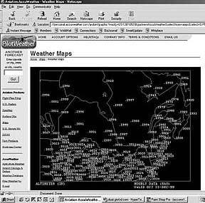
Accuweather
Accuweather (www.accuweather.com) is a general weather service, with Pilotweather (www.pilotweather.com) being its tailored aviation service. The subscription price is $4.95/month, with discounts for six-month and one-year packages.
Whats interesting about the Pilotweather site is that much of it is available to pilots for free. Even without paying the freight, pilots can obtain a range of satellite images, charts of altimeter settings, surface visibilities, surface winds, freezing level, ceiling reports and winds aloft and weather depiction now and into the next 12 to 36 hours.
These charts arent the prettiest available, but the price is right. Radar information is also available with minimal delays, both NEXRAD and regular displays. We werent keen on the severe weather chart as it merely shows some blobs of color on the map without text or explanation.
Some NWS fax charts of the type that we used to see on the walls of FSSs (back when there were FSSs) are available on Accuweather, including the radar composite, weather depiction and the four-panel observed winds aloft charts.
We happen to like these and would like to see four-panel 12/24 hour prog chart available as well. NOTAMs, PIREPs and all of the other usual text products are available by state, region or specific location, with METARs subject to being decoded at the users option. The data appears to be current here, too, which is a plus, but not all weather reporting stations come up when a state or region is selected.
The route briefing function of Pilotweather has some nice touches but is flawed in execution, in our view. We like the automatic NEXRAD image for the departure point, with quick links for destination and alternate radars. Links are also available for national radar and a current flight rules chart. These features play to the strength of Web-based briefing tools in showing radar, charts and maps in a way thats useful to pilots.
TAFs are given if the selected location has those forecasts published, but the function isn’t smart enough to look 15 miles up the road to get a TAF from a neighboring field if necessary. Area forecasts, AIRMETs and SIGMETs are also provided, but surprisingly not all NOTAMs are retrieved for the selected airports and no FDs are given for the selected stations or enroute.
The weather at intermediate stations is not given, either. If Pilotweather could add winds aloft and fix the NOTAM glitch, it would be the winner in the route briefing category. One feature we liked is the hour-by-hour weather function that shows in tabular form the expected wind speeds, direction, ceilings, precipitation, temperature and dewpoint for a 12-hour forecast period.
If you pay the fee for the premium Pilotweather service, you get faster updates on radar displays (of dubious practical importance, we think), 10-day local forecasts (we find even five-day forecasts notoriously inaccurate) and the ability to file FAA flight plans via GTE DUATS. To us, thats hardly worth the $39.95 that a yearly subscription costs.
Despite everything Pilotweather has going for it, its most significant drawback as either a free or a pay service is its maddeningly slow load rate. We were victimized by multiple hangs, for minutes at a time, which made the service all but unusable. Frequently, during our evaluation, we went first to Pilotweather only to flip to another provider because of the glacial download rate, which was true with both a 56K modem on a notebook and a T1 line in the office. Pilotweather is slower than the rest of the pack by a long shot.
WSI
The WSI aviation weather site (www.pilotbrief.com) is not for the faint of heart or thin of wallet. At $79.95/month, its clearly the higher-priced spread and likely out of the league of most light aircraft GA customers. One of the major airlines uses it for briefing its crews and in 2000, all of the AFSSs will be using WSI charts.
Part of the cost is attributable to multiple-redundant servers designed to provide service on as consistent a basis as is possible on the Web, something other pay providers have had some trouble doing. Despite the cost, its a fine product and speedy, too. WSI has the best graphic portrayal of SIGMETs and AIRMETs that weve seen, putting a lot of information in front of the pilot and making it easily understood with text and color.
The surface analysis charts show precip nicely. Text weather can be called up by individual identifiers or by states and WSI is the only pay provider we surveyed that permits groupings of multiple states.
Alas, however, the WSI route briefing function has some warts shared with the other cheaper providers. It doesnt integrate graphics into the route briefing output. Although the WSI route brief ably picks up current weather from stations surrounding the departure and destination airports, it doesnt pick up TAFs nearby to the destination when no TAF is issued for that airport.
Enroute METARs are provided, but the FDs given for a typical 500-mile route had no forecasts shown for the first half of the flight and missed some obvious ones that are on a direct flightpath.
And, for one destination we checked, it didnt pick up the NOTAMs issued and current on DUAT. Not a bad design, overall, but not exceptionally good, either.
Conclusions
Right up front, we think pay-per-use weather is a good idea. Its easily worth $5 a month, if it adds some value to whats available for free. With that in mind, how do these services ultimately stack up? No clear winners but one clear conclusion: The Web can deliver a one-stop briefing but not easily or elegantly. Yet.
We were distressed to see the lack of imagination evident in the mundane, boring and not very informative design of the route briefing functions across all of the providers.
The Web seems to be a natural to meld graphical displays with text information, providing the user with visualizations of the weather that are worth thousands of code contractions. This capability simply isn’t being used to date with the sole exception of Accuweathers positioning of a departure radar display at the head of a route briefing.
The flight briefing products all need substantial work in that they are almost uniformly poor in providing appropriate weather when a selected airport doesnt have TAFs or FDs. The DUAT providers have been able to provide a substantially better text-based briefing product for years and there’s no excuse for cutting-edge Web weather providers not to do as well. And whats up with this lack of NOTAMS? How hard can that be?
But for the significant speed problems we experienced with Pilotweather from Accuweather, we rate it best of the decidedly mediocre pack for content and for its price (free, for about 99 percent of what we care about). After that, Flightbrief-and, at least for now, Weatherconcepts-is in our second place slot.
Weathertap is good, but not a standout. The lack of NOTAMs means that the user has to access other sites or call a briefer so there’s no one-stop advantage with Weathertap. DTN has the basics, but its cost and lack of innovation, not to mention the lack of NOTAMs or a route briefer and the stale data problems, put it at the back of the pack, in our opinion.
What would we do in deciding which service to use? Frankly, as indicated in the sidebar, were more impressed with some of the government-sponsored Web delivery systems than we are with the products that were the focus of this article.
The ADDS web site with its Flight Path Tool, while experimental, is excellent in using graphics to communicate critical information. The DTC and GTE DUAT sites offer a solid briefing product, including the ability to tailor briefings so the output isn’t overwhelmingly FDC NOTAMs, and include fully serviceable flight planners.
Between them, we think that were as we’ll or better served than we are by visiting a pay site. A year from now, we hope we can say otherwise.
Also With This Article
Click here to view the Web Weather Services Comparison.
Click here to view “What You Get for Free: Quite a Lot, Actually.”
-by Scott Dyer
J. Scott Dyer is an attorney and ATP. He owns a Cessna 210 based at Westchester County near New York.