AvMap EKP-V: Strong Display, But No Touch

This rugged electronic kneepad GPS offers an impressive display, good terrain warnings and full approach integration, but no touchscreen or wireless.

We don’t envy Italian GPS veteran AvMap in their attempt to compete in today’s world of cockpit iPad and with Garmin’s well-rounded line of portable navigators. Garmin and Apple all but own the aviation GPS and mapping market. Still, we’ve been impressed with nearly every model of AvMap navigator we’ve tested over the years. The company has a knack for offering high-end mapping displays packaged in a case that’s convenient and rugged enough to throw around the most hostile cockpit.

288

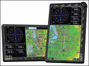
And so it goes with the new flagship EKP-V. We were surprised that the latest-generation EKP doesn’t have a touchscreen. But the unit’s utilitarian capability and brilliant screen take the bite out of this shortcoming. Some might even prefer it.

Tactical Footprint
Our editorial schedule delayed our review of the EKP-V, which gave us several months to live with the unit in our day-to-day flying chores and on several sizeable trips. Its chassis size of 4.3 inches x 6.8 inches x 0.8 inches allowed for easy storage in a flight bag side pocket, on the copilot and back seats, and stashed in our backpack for daily airport commutes on motorcycle.

EKP stands for electronic kneepad, and the 14-ounce unit also proved the perfect size and weight for strapping around our leg with the included Velcro leg strap. The strap attaches to a bracket mount shaped for your upper thigh.

But the unit is also worthy for use as a mini MFD as many LSA and experimental owners have done. The pressure-fit docking station houses two serial data ports, a USB connection, audio/video input and audio output. This connector assembly makes it possible to hardwire the unit to an autopilot for left/right steering commands, Zaon portable for traffic alerts or an XM weather receiver for datalink. Datalink is not built into the unit.

There’s no Bluetooth connectivity, so saddling the unit to any of these devices while strapped to your leg is going to create a gaggle of wiring mess that just isn’t practical. To us, this is way old school in a day where wireless iPads are a proven and respected cockpit tool.

Battery endurance is roughly four hours. You can squeeze out a bit more juice while in battery saver mode, which automatically dims the display when not in use, but you’ll want to plug the EKP in for regular use to take advantage of its terrific display at full brightness. The battery charges while plugged in. You can plug the unit into a USB port using a supplied cable for a slow charge as well.

The EKP-V display, a seven-inch 16,000-color LCD of 800 x 400, proved a crisp read and provided excellent visibility in all lighting conditions including one bright Florida sun-splashed cabin. It was equally comfortable in a dark late night cabin, thanks to a linear manual dimming control. A portrait presentation is obviously most practical for kneeboard use. We prefer landscape mode for better use of the map. The EKP-V offers both.

288

If you come from a Garmin portable, the Avmap’s feature set will seem foreign at first, but the controls and overall bezel design are uncluttered and reasonably logical. The EKP-V has 10 mode buttons mounted along the top and down the right side of the face. The enigmatic F1 key is for your most-used functions. For instance, you can customize F1 so it activates the find-airport command, user waypoints or custom checklists—a feature we liked.

A joystick is housed on the upper right corner (or lower right, depending on how you hold the unit) is integral for panning the map display, and serves as an enter key. We think this joystick (more of a fat knob than a stick) should be a tad larger for ease of use. Below the joystick is a thumb wheel that AvMap calls a smart wheel. It’s used for zooming the map and navigating the menu structure. These controls have a durable and positive feel, but can be frustrating to use in the bumps. More on that in a bit.

Solid Mapping and GPS
The EKP’s WAAS GPS receiver performed well in both high- and low-wing aircraft using the built-in antenna—impressive for a unit that’s buried low in the cabin when strapped to your leg. There is an optional remote antenna. Additional data storage (software and mapping data) is via a preloaded Micro SD card.

There’s room to store 50 flight plans, but when we tried to build some on the fly, we became frustrated. Instead, we cut to the chase and found ourselves panning the map, placing the cursor on the point we wanted to go and pounding the familiar GOTO button. The position selected from the map now becomes the active destination and you’re on your way. This is straight-forward for on-the-fly navigation, but we think some popular iPad apps do better, thanks to touchscreen.

You could also dial in a waypoint by using the GOTO button and dial by identifier using the virtual keyboard (and the smart wheel). At times we found the smart wheel to be a bit too sensitive, blowing past a letter we intended to pluck from the virtual keyboard. AvMap makes the task easier by presenting a list of possible waypoints while you edit. If you want to go to Myrtle Beach, it appears by the time you dial “KMY.”

Placing the bulls-eye cursor on top of a map object opens a helpful information window with the objects name, LAT/LON position on the map, bearing and elevation. Push down on the joystick, and you’ll get everything you’d want to know about it. For airports that includes runway length, frequencies, fuel service and so on.

288

The MODE button configures screen overlay, including map data, TAWS, weather and traffic. Speaking of weather, the EKP has the ability to display a host of XM Weather products from third-party wired receivers including Nexrad, Precip, METAR, TAF, TFR and lightning data. We didn’t get to try weather on the unit we tested but, given the high-quality display and fast processor, it should work well.

Charting an Approach
Loading an approach procedure from an active flight plan is intuitive from the flight plan menu and subsequent flight plan tab, where you have the option for selecting an approach. The legs of the approach are drawn directly on the moving map and drive the EKP’s HSI—a real benefit, in our view.

Georeferenced approach plates and airport diagrams for the EKP are provided by Seattle Avionics. Annual subscriptions are $99 and include plates, airport diagrams, arrival and departure procedures. The unit also uses Jeppesen navigational data and includes low airways and private airfields plus VFR reporting points.

The easiest way to call up a chart is through the MAP button, where a drop-down list of available charts for the active waypoint appears. We found the EKP to be a fine chart reader that’s both easy to work with and read at a glance. To change an approach on the fly, the GOTO button works best. Here you have the option of deleting or changing the approach, resynching the active go-to waypoint or simply changing the active waypoint.

The NEAR key is also an easy way to change an active waypoint and the quick processor breezes through pages of airports, airfields, heliports, VORs, NDBs, intersections, ARTCC, FSS and user waypoints nearest to the existing fix.

Navigating the Terrain
TAWS functionality has dual settings: low separation and high separation with obvious color-coding that’s based on the aircraft’s separation from the terrain or obstacles. High separation paints obstacles red when they’re less than 1000 feet below you. Low separation downgrades this to 500 feet.

Enabling the vertical profile view in conjunction with the TAWS map overlay mode offers sizeable amounts of terrain awareness. Terrain peaks in the profile offer color-coded warnings that we found accurate based on actual terrain.

Waypoint data has the expected choices for bearing, track, distance, ground speed and so forth. There’s also a basic, yet effective, HSI with course needle and vertical descent guidance. A split screen works in portrait or landscape mode.

Missing from the EKP is PFD-like flight instrumentation and synthetic vision. We think these may be more buzz than substance on a portable. But a mapping function that AvMap has always nailed is in its accurate terrain depiction and it’s carried over into the EKP-V.

Conclusion
The EKP-V has a list price of $1998, which closes in on the street pricing for Garmin’s aera795. Head to head, we give the EKP-V the slight convenient size advantage given its thinner case, lighter profile and the ability to wear it as a knee board. Still, gadget freaks will likely be drawn to the 795 with its virtual 3D Vision technology, touchscreen feature set and Garmin brand recognition.

We think the EKP-V would be a better product with a touchscreen. That said, AvMap told us they purposely avoided touchscreen because they couldn’t find a touch technology with an acceptably high-def screen and that customer feedback hinted that there’s still a desire for traditional controls.

For no-nonsense portable navigation that impresses with a brilliant display and excellent mapping, we think the EKP-V is a worthy consideration when shopping the mid-priced GPS market.

Click Here

Editor in Chief Larry Anglisano has been a staple at Aviation Consumer since 1995. An active land, sea and glider pilot, Larry has over 30 years’ experience as an avionics repairman and flight test pilot. He’s the editorial director overseeing sister publications Aviation Safety magazine, IFR magazine and is a regular contributor to KITPLANES magazine with his Avionics Bootcamp column.