ForeFlight Mobil 6.6: Synthetic Vision, MOS

ForeFlights app version 6.6 brings synthetic vision, plus MOS weather data to airports without TAFs. We think its imagery threatens panel displays.

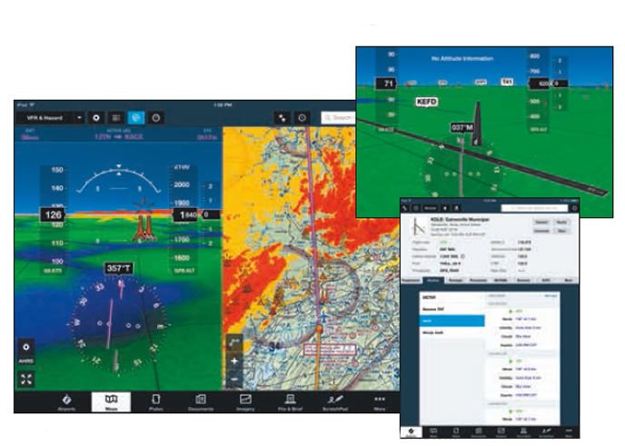
As much as we like the ForeFlight Mobil app for iPad, weve been waiting for more advanced features that make better use of the iPads processing horsepower. The short list included synthetic vision and a better HSI presentation. Thats just what ForeFlight has done with the latest version 6.6 upgrade. It includes intelligent, next-gen synthetic vision that we think betters aging certified displays.

There is also a new NOAA weather prediction function, providing supplemental weather data for some airports not served by TAFs.

Since we reported on the major enhancements made in ForeFlight Mobil version 6.1 in our August 2014 issue, well concentrate on synthetic vision and weather functions here.

Synthetic Vision
The SV synthetic vision function can replace the traditional attitude indicator display view. Existing users pay the $25 download cost for the function thats created in the apps Map view and activated by tapping the attitude indicator button in the top menu bar.

When connected to an Appareo Stratus 2 ADS-B receiver, the display will also include AHRS-derived pitch and roll horizon data. If you dont use a Stratus 2, you wont get pitch or roll data and the horizon will remain fixed, regardless of the aircrafts attitude. Its stark by SV comparison.

When SV is on, the display includes a 3D depiction of the terrain in front of the aircraft, while familiar terrain awareness coloring depicts threat terrain and obstructions all around. Terrain that is more than 1000 feet below is green, yellow if its within 1000 feet below and red if its within 100 feet below or above.

We ran SV on the latest iPad mini 3 and were awed with its graphics-better than many certified displays weve used. Synthetic data should be judged not only by landscape detail, but also by its precision and accuracy as the aircraft progresses within the synthetic environment. ForeFlight SV passes, with synthetic airport markers and runways realistically coming into and fading out of view as you approach and pass them. This keep screen clutter to a minimum, an issue that plagues smaller panel displays.

Runway depiction is based partly on its surface conditions, whether asphalt, dirt or grass, and by the water and land features that surround it.

Terrain signatures are enhanced with grid lines and shadows. Their placement on rolling hills offer a better read on peaks and valleys.

Speaking of landscape, when the iPad is in landscape orientation, the attitude and syn vis display is shown on the left side of the screen. In portrait orientation, attitude and synthetic vision is at the top.
On a side note, one feature that impresses is the automatic night transition mode, where the sky begins to dim gradually 20 minutes before local sunset. Twenty minutes before sunrise, it brightens. Its quite realistic.

MOS FORECASTING
In addition to TAF data, version 6.6 includes MOS, for Model Output Statistics. MOS is new to ForeFlight, but its a NOAA tool thats been around for decades. In a nutshell, MOS produces forecasts for specific U.S. stations-for our purposes, airports-based on weather prediction models and statistics. This includes prior surface observations and geoclimate data, including elevation, terrain, climatology and time of year. Scott Dennstaedt, ForeFlights weather scientist and MOS feature architect, pointed out that forecasters issue TAFs at only 635 airports throughout the U.S., leaving over 3000 airports without any site-specific data. MOS forecasts are available at approximately 1200 more airports in the U.S.

MOS provides an hour-by-hour forecast projection over a 24-hour period, including ceiling height, sky cover, prevailing visibility, plus wind speed and direction. One tactical approach might be to leverage the MOS forecast to supplement an area forecast. But its not a TAF.

Since MOS forecasts can have hour-by-hour repetition, ForeFlight takes the hourly MOS guidance and collapses it into forecasting groups that are just similar to what you would see in a TAF. Its not a legal replacement for area forecasts, but intended for supplemental reference. Youll need to be familiar with sizable limitations of MOS data, too.

Dennstaed cautioned MOS cannot forecast multiple cloud layers as you see in a TAF. Except for when the forecast is shown as clear, a single fixed cloud layer is the best MOS can do. It cannot directly forecast showers, thunderstorms and fog in the vicinity, nor can it forecast precipitation intensity.

In advance of version 6.6, ForeFlight added color enhancement to the infrared satellite imaging presentation. Coloring the ground-based IR image is intended to get a better read on cloud temperatures at higher altitudes. The imagery is on a 30-minute refresh cycle and is found in the map mode menu while in Maps view.

The $174.99 per year Pro SV package (and Pro SV for Canada) is the flagship subscription, while the scaled-back Basic SV is $99.99. Visit www.foreflight.com.