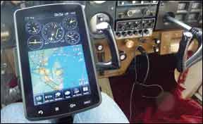
Now that the iPad has become the consumer electronics version of The Borg, powered along by hundreds of aviation apps, have we seen the last of the dedicated GPS portables? As we went to press this month, Garmin answered that with a new product called the aera 796. It was due to be rolled out at AOPA’s Summit event in Hartford, Connecticut.
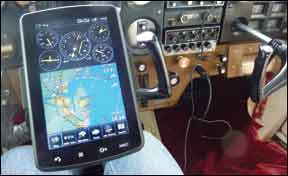
The aera 796 builds on some of the 696’s capabilities, sells in the same premium price range and, in our view, is clearly meant to blunt the onslaught of iPad apps that now do things you didn’t even realize you wanted, much less needed. As with the previous products, there are two models, the 795 ($2199), without the weatherlink option, and the weather-capable 796 retailing for $2499.
Aera Era
The product designation tells the tale with this new navigator. It’s an aera, not a GPSmap, so it springs from the newest lineage of Garmin’s navigators, not the old-school products which really date back to the GPSmap 396 introduced in 2005. In a nutshell, that means a faster processor, longer battery life, a high-resolution display and—the biggie—touchscreen control with pinch scaling. There’s passing resemblance between the two lines in operating logic, but the menu-driven screen touch method is just way faster and easier to master, in our view, especially with the virtual keyboard.
Although the aera 796 has the same screen size and pixel count as the 696 (7-inch diagonal and 480 by 800 pixels), the guts of the machine itself are different. It has a much faster video processor—noticeable in screen refreshes—and the overall physical size is smaller. The 696 is 5.7 by 7.7 by 2 inches deep, while the 796 is 5.1 by 8 by 1.5 inches deep. With the smaller size comes less weight. The 796 weighs 1.65 pounds compared to 2.2 pounds for the 696. That’s a welcome slimming down, because in turbulence, the 696 could stress test the yoke mount if not carefully secured.
As is obvious from the sideview on the next page, the 796 has a more sculpted, consumer electronics look than the rather boxy 696. It also has a bunch of input/output options, including a USB port and a couple of jacks for things like remote traffic and/or interfaces for non-certified auto-pilots, crossfill into GNS/GTN series navigators and frequency data loading into the SL30/SL40 navcomms.
How about Bluetooth? Garmin would neither confirm nor deny this capability, so we suspect the box has it, or it will become available with a future release. Given the competitive landscape, it’s hard to imagine not having some kind of wireless interface. We wouldn’t be too surprised if, as with the iPad, some sort of portable gyro pack appears, but that’s our speculation, not a hint from Garmin.
Nice Touch
But what Garmin did mention is the new touchscreen technology, using the capacitive design most smart phones have rather the resistive design used in the rest of the aera line. Recall that resistive touchscreens work with a pair of thin layers whose resistance changes when the two layers are physically moved closer together by the touch of a finger or stylus. They work we’ll with stylus contact, but require a firmer touch when a finger is used. That means they’re less susceptible to unintended commands, but will also occasionally need a second or third jab to respond to a desired command.
Capacitive sensors detect anything that has a different dielectric value than air—your finger, but not the eraser of a pencil, for instance. As a result, they’re both more sensitive and precise. Why the change for the 796?
“With the larger display, resistive doesn’t work quite as we’ll and the pinch scaling you can’t do nearly as well, if at all, with the resistive technology,” says Garmin’s Jim Alpiser.
“Another thing we really look at is screen brightness and that also drives a lot of the design considerations. Being able to drive the brightness of the display that we want means that typically, we need to have a more robust size display, which then also drives your battery life considerations,” Alpiser added.
We weren’t able to get specific specs on the battery other than life (4 to 8 hours, depending on brightness and whether the XM antenna is in use) and technology type. It’s a lithium ion that is, interestingly, higher capacity but of a smaller physical size than the nickel metal hydride battery used in the GPSmap 696.

101
Menu Ops
The aera 796 operating logic is similar to the other aera models, but it has some additional features so there are some new icons on the menu. There are, however, no hard keys—at least in the traditional sense of hard keys.
Along the bottom of the bezel are four keys which correspond to hard functions, but they’re touch buttons, not reiterative keys. Two are immediately obvious—NRST and Direct-To—and two aren’t so obvious. And this is where the 796 ran slightly afoul of our can-an-idiot-operate-it-without-instructions test. The far left key is labeled with a swirly arrow—it’s both a back key and a home key. The key immediately to the right is obviously some kind of list or menu key and in context, it pulls up options related to the operation or display at hand. For instance, on a chart page, the menu key will offer the choice of VFR, IFR or approach charts. Pretty simple.
To avoid that out-of-the-box confusion, we think the back key could be labeled home, which is how the other aeras are set up, albeit with virtual keys. The Direct-To and NRST keys are obvious.
Along the bottom of the screen are six dedicated icons for specific functions. You can hide these if you prefer or customize them. If you use the SirusXM tuning a lot, for example, you can replace one of the other icons—say the terrain icon—with that button. All of this is done through a tools/setup step- through that’s fairly easy to figure out without plowing through the manual.
Garmin has obviously spent its developmental bucks on useful core features such as charts and plates, the 3D Vision and a few other trinkets, but not a lot of high-level customizable choices that nobody uses. This makes for a product that’s deep enough for the money, but not around the bend in look-how-clever-I-am features.
3D Vision
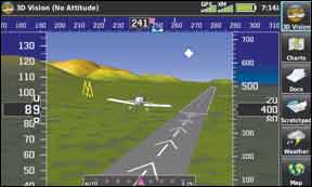
That’s what Garmin calls what really amounts to synthetic vision applied to a portable. But it’s synthetic vision with a twist. When you press the 3D Vision icon, you’re presented with a rear-end view of a low-wing single-engine airplane. In front of it is the synthetic vision horizon, complete with terrain, water features, obstacles, airports and runway detail, including some signage. For comparison purposes, it looks more or less like a G500/600 with the miniature airplane in place of the AI in the full-up PDF system.
For years, every Garmin portable has had the company’s cleverly engineered flight panel page, which uses GPS-derived data to drive synthetic flight instruments. And that’s what’s driving the 3D Vision. The response is not quite as fluid as a full-up ADAHRS, but it’s workable.
On either side of the miniature airplane are altitude and airspeed tapes, with a tape-type heading indicator along the top edge. The bottom of the display has a CDI indicator. What’s especially cool about the 3D Vision is that if you touch the screen, you can finger scroll around to view what’s around the airplane through 360 degrees, with all the relevant terrain details in view. While you’re scrolling, the data tapes withdraw, then reappear in about 10 seconds when the display goes back to the default rear view. You can even look directly under or below the airplane. (No belly stains visible.)
The only weakness of this impressive bit of technology is that it can’t show pitch changes or attitude and a conspicuous message at the top of the screen tells you as much. But is it good enough to keep you upright and from running into terrain and obstacles? We certainly don’t see why not. Dynamic response is good, if not instant, and in several of our trials of the flight panel page in cloud or simulated IMC, pilots had no trouble maintaining control of the airplane.
Charts and Plates
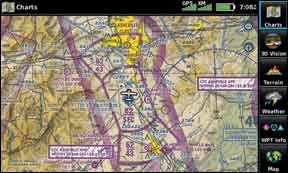
In addition to the 3D Vision feature, the 796’s other enhanced capability is in charting, which it does quite impressively. Four chart options are available under Garmin’s FliteCharts feature: Visual or sectional charts, IFR high and low charts and the FAA’s AeroNav approach charts. These are stored as what are essentially PDF-type files, which the 796 reads and displays. And these are the real deal, not stylized renderings. In fact, Garmin says the 796 can qualify as a Class I or II EFB.
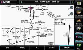
Charts are accessible through several methods. Touching the dedicated chart button reverts the entire screen to whatever chart mode was selected last. If you want to switch, say from IFR enroute to VFR charts, pressing the menu key brings up the list. Or, you can get at the plates through the nearest function by selecting an airport and then touching the TERPs tab.
Each chart—whether enroute or approach—is fully scalable via pinching and you’ll need it. With the plate occupying the full display, the details simply aren’t readable. But you can easily pinch to the desired scale, then finger scroll to the point you want to read on the chart. To browse through multiple charts for one airport, touch one of two small green arrows at the top of the screen. It takes about a second to load each plate.
The 696 didn’t get georeferencing until a later version, but the aera 796 does this right out of the box on all of its charts. On approach plates, the georeferenced aircraft appears only in the plan view, not the profile, so as you scroll around the plate, the aircraft symbol might not always be in view.
Approaches can be added to a flightplan and there’s a choice of vectors o the full approach. When airports are listed as waypoints, Garmin’s SafeTaxi feature automatically pops up the airport diagram when scaled up.
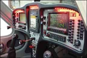
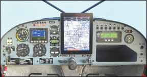
Like the iPad, the 796 can be viewed in either landscape or portrait mode, but unlike the iPad, it doesn’t do this automatically when the device is rotated. Given how annoying this can be in the iPad—some users lock out the automatic rotation—we’re not sure we want an autorotation option in a GPS navigator/chart reader. But we can see the advantage of the landscape mode merely to fit the device into a panel, especially an LSA.
Other Features
The aera 796 has a few other features worth mentioning, not the least of which is XMWX Satellite weather, which it handles and displays well. By stepping through the menu behind the weather key, you can display the full range of XM products, from echo tops, to freeze levels, to graphic METARs. This functionality is no different than the earlier aeras, but it’s easier to manipulate because of the larger screen.
With its sensitive capacitive touchscreen, the 796 is capable of another trick: It has a scratchpad. Basically, this allows you to draw or write with your finger. You’ll win no penmanship awards, but the scrawling is legible and it’s adequate for jotting down a clearance. To make much use of it, however, you’d probably want to place the scratchpad access icon on the page buttons menu bar at the bottom of the page. Along with this capability, the 796 can also store and read PDFs for flight manuals, ops specs and checklists. There’s also a built-in checklist capability.
Although neither the 696 or 796 are intended as ground navigators, the 796 has Garmin’s City Navigator database aboard. “It’s primarily for helicopter or tour operators. They may want to be able to do direct-to navigation to an address, for police or EMS agencies. It does not provide the turn-by-turn function as traditional automotive navigators do,” says Alpiser.
Conclusion
So what have we got here? At first, we thought the 796 was just a tarted up version of the 696 with touchscreen. But the more we used it, we realized that a more accurate description might be that it’s a solid compact chart and plate reader that happens to have GPS navigation and weather capability, not to mention SiriusXM entertainment.
We think the thing is we’ll designed and easy to use, although we would would re-label that arrow key as a home/back key. A minor nit; you can figure it out. So how does it compare to an iPad? We’ll answer that question in detail in a separate review. For the time being, its aviation functionality is more robust than the iPad, typically. It’s more self-contained, with no need to fuss with third-party hardware. The charts are easily accessible and you can count on the airborne weather being there. The screen is also crisp and glare free and brighter than the iPad when viewed side by side.
On the other hand, it costs more than twice as much as a fully tricked out iPad and it doesn’t run the iPad’s thousands of general purpose and aviation apps. As we report on page 14 of this issue, however, iPad third-party hardware and software costs add up and you have to connect it all. We’ll do the cost comparison next time out.
If budget isn’t the sole driving consideration, we think the 796 is a good value and we have no reservations in recommending it, especially for pilots who want an approved EFB.

