Datalink weather from WSI (Weather Services International) or through XM-based WxWorx, are far more alike than different. Even the pricing is identical for the basic and second-tier service, at $29.99 and $49.99 a month respectively. But close examination reveals a few key differences. Remember that vendors, such as Avidyne or NavAero, decide how to display the data from either service in any manner they choose, and even what data to display. WSI (WSI InFlight) and WxWorx (WxWorx on Wings) both provide their own software that displays all of their broadcast products, so thats what we’ll use for our head-to-head comparison.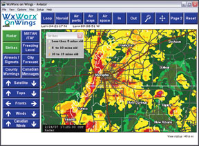
No Winner on NEXRAD
Ground-based radar is the cash cow of both services. Its high glance-value is the reason why pilots justify the fixed $30 or $50 monthly subscription. There is no clear-cut winner since both vendors broadcast a nearly identical ground-based radar product thatll tell you where you are likely to spill your coffee.
The image you see in the cockpit is not the same as the image found on the NWS web site. Thats because both WSI and WxWorx do a fair amount of data massaging before the image reaches your satellite receiver. Sometimes this quality-control step improves the image, and sometimes it eliminates real features.
For example, WxWorx uses a gross filter to eliminate any returns that are under 10 dBZ, which are usually not of significance to the pilot. However, this eliminates the presentation of gust fronts and outflow boundaries from thunderstorms, which often show up as low dBZ returns. WxWorxs also adds a step that eliminates ground returns in Canadian weather that look like storms but arent. WSI doesnt do anything about these returns, so a pilot using WSI Canadian radar may see nasty returns that arent storms at all.