In a flight planning app market that’s been dominated by Apple iOS, it’s easy to overlook apps designed specifically for the Android platform, but we think that’s changing. Tablets from Samsung, Google and others are proving to be just as capable as Apple’s offerings for less money.
If you’ve been away from Android for a while, don’t underestimate its processing power and overall ability to support a new breed of highly capable cockpit apps. An example is FlightPro. Even after using it for a short time, we were impressed with its intuitive feature set, shallow menu structure and speed. We also like that it presents at-a-glance waypoint and weather data, in addition to seamless DUATS flight planning.
Simple menus
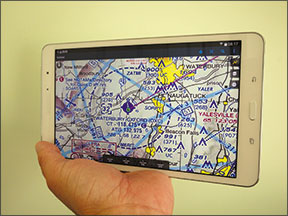
The FlightPro app is compatible with most every Android device with software version 4.0 or later. FlightPro says it regularly tests on Nexus 7 and Xyboard 8.2, so these are sure-thing compatible devices. We evaluated the app on a Samsung Galaxy Tab Pro 8.4, which sells for around $350 and at 5 x 8.62 x 0.28 inches, found it to be nearly the perfect size for the cockpit. We give its screen quality and battery endurance a slight edge over the iPad mini.
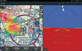
FlightPro has minimal menu icons, adding to the apps simplicity. There’s a basic navigation bar at the bottom of the screen that displays active navigation data fields (distance to waypoint, ETA, ETE) and there’s also a selectable onscreen magnetic rose. It can be configured to display a CDI that automatically uses terminal, enroute and approach course-width scaling. As you would expect, a magenta course rhumb line is displayed on the map.
There’s an integral, map-overlayed altimeter label that auto-adjusts every 15 seconds when the app is receiving valid weather data. When altimeter data is between 60 and 75 minutes old, the altitude will display in yellow. When the altimeter is more than 75 minutes old, altitude will display in red.
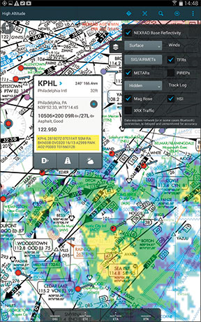
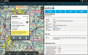
Nearest airports are selected from a dedicated icon from the menu bar at the top of the screen. The upper menu bar also has a POI icon, for point of interest, to manually key in a waypoint name. The app has a full-screen or split-screen mode that’s useful for displaying various maps, in addition to side-by-side waypoint and weather data. A major function of the app is the Info Box, which appears after touching an airport on the map. There’s also a Details View (a digital version of the airport facilities directory), which tells you everything you could possibly want to know about a waypoint, including frequencies, runway data, available
fuel types and also the current weather, including the METAR and TAF.
At the bottom of the waypoint Info Box is an action bar with three icons, including a direct-to command that navigates directly to the associated waypoint.
The Info Box runway highlight icon is for selecting the intended runway for departure or approach. When in the runway highlight mode, the map shows extended runway centerlines with arrows that indicate the direction of the traffic pattern. Nifty and helpful.
There’s also a weather icon for displaying textual and weather images, including METAR history, TAF, local radar and radar tops, to name a few products. You’ll need an Internet connection or a compatible ADS-B or XM receiver. Currently, FlightPro is compatible with Baron MobileLink XM, SkyRadar and the iLevil ADS-B, plus the Dual XGPS170 ADS-B receiver via Bluetooth connection. Weather is configured with the onscreen Layers Tab. While open, it enables options for displaying or decluttering weather products, based on compatible driving receivers.
If you ever get lost on the onscreen map (after panning a long distance on a busy sectional, for example), there’s a dedicated icon that automatically centers the chart on the current position. There’s also the option to change the size of the on-chart font and the ownship icon, accessed in a generous preferences menu.
Subscription, DUATS
The $149.99 Premium yearly subscription package includes georeferenced charting that’s provided by Seattle Avionics. You get airport taxi diagrams, approach plates, sectional charts and high and low airway charts. The Standard subscription tier has the same charting, but no approach plate and taxi chart georeferencing (the aircraft won’t appear on the chart). Charts are selected from a drop-down chart menu on the upper left corner of the screen.
There’s a dedicated flight plan tab, with drop-down options for clearing, inverting and loading flight plans. Flight plan data is automatically transferred to the Flight Pad Briefing tab, where it can be edited or sent to your DUATS account. A dedicated Request prompt in the Briefing tab requests a weather briefing, with the option to file the flight plan.
The Flight Pad also has a runway- finding feature. It displays a representation of your aircraft in relation to the runway that’s in use. The Scribbles function is a note pad for writing clearances and illustrations.
Why droid only?
That’s what we asked FlightPro’s Paul Coleman, who told us that the Android platform is edging Apple iOS in popularity.
“An announcement was made recently that Android surpassed iOS, making it the most popular mobile platform in the world. The development platform for Android is more common and there are significantly more developers for Android versus iOS,” he said.
We’re not so sure that’s the case with aviation app designers, with top apps including ForeFlight Mobile and Jeppesen only serving Apple iOS. On the other hand, if Android tablets continue to increase in popularity as they seem to be doing, these aviation tablet app developers could have some serious programming to do. Based on our trials, FlightPro would be the one for them to beat once it gains a few lacking features, including terrain and synthetic vision. Contact www.flightpro.com for a trial subscription.