ForeFlight 3D Approach Preview:

ForeFlight's latest approach graphics are useful for briefing the approach during preflight. A missed approach preview would make it better.

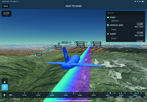
ForeFlight introduced its 3D Preview feature awhile back, but now version 12-2 is enhanced with 3D Approach Preview, standard on Performance Plus subscriptions.

The idea behind 3D Approach Preview is to better visualize what the approach segment will look like  (down to the runway threshold)because it creates onscreen markers for each waypoint in a route, plus labeled approach fixes for a given instrument approach. 

If you haven’t used ForeFlight’s 3D Review feature, it essentially lets you follow the path of a planned (or recorded) flight overlaid over high-res aerial imagery and terrain. The feature uses parent company Jeppesen-sourced high-res worldwide terrain data.

The new 3D Approach Preview displays an interactive nav log at the bottom of the screen for viewing each waypoint and the distances between them, and you’re able to advance to any leg in the planned flight for preview. Think of it as a timeline of a planned flight. 

The first step is to create a route on the Maps or Flights view in the app, and select the 3D button. The utility then displays each waypoint along the route using the identical markers that are shown on the map. Each leg is color coded to indicate past, current and future legs in the route. There’s orange for where you’ve already been, magenta for your current leg and blue for where you’ll be next. 

The interactive nav log is for viewing the distances between each waypoint in the flight plan. The nav log is in the Route window and you can tap a waypoint to advance to that leg in the flight. If there’s an approach that’s part of the flight plan, you’ll see speed and altitude restrictions for each waypoint associated with the approach. For example, if you need to be at 9000 feet and at maximum speed of 190 knots at the initial approach fix, these restrictions will be included in the IAF waypoint label, and for others in the approach.

As for virtual imagery, the app now includes the altitude restrictions in 3D. The benefit here is a realistic depiction of the approach’s glideslope in relation to the surrounding terrain.

It’s important to stress that this data is really intended to be previewed and not used as you would when flying with a synthetic vision utility. Plus, you’ll need an internet connection to download the data. But you can use it in flight once it’s downloaded.

To access and brief a 3D approach detail within the app, go to the route editor in the FPL menu and tap the approach bubble for the one you want to brief. Then select 3D Procedure Preview. This will open the 3D Preview utility at the beginning of the approach without having to advance through the entire route. 

One thing we wished 3D Approach had was a depiction of the missed approach procedures. This would be a pretty useful tool whether you’re familiar with the approach or not. We suspect ForeFlight is working on that next. 

MOUNTAIN PASSES AND HIGHWAYS

ForeFlight version 12-2 also includes mountain passes in its high-resolution base mapping. This mapping includes Jeppesen-sourced terrain and highway labels for enhanced VFR mountain flying. Labels for major highways and roads apply to U.S. interstates and federal and state highways. In the Map Settings menu, you’ll see a Cultural Elements and Major Roads tab to turn them on.

The screen grab shows how 3D Approach/View depicts altitude and speed restrictions for specific waypoints in the flight plan and approach procedures. The timeline playback at the bottom is set for 20 times the normal speed to quickly advance through the segment.

Some users have contacted us reporting that they couldn’t access the mountain pass feature, but you need to download the high-res mapping first. To access it, download the high-res base map for any region in the app’s Downloads section. Once the appropriate high-res base map is downloaded you’ll have mountain passes for the U.S. and Europe, and mountain pass icons are oriented on the map based on direction, plus they indicate the pass name and elevation. For Europe, the base mapping feature even depicts gondolas and cables, including their maximum elevation. 

This image is what the high-resolution base map looks like with mountain passes turned on. The white arrows point to the Loveland and Berthoud passes in Colorado.

You can turn the mountain passes depiction on or off through Map Settings and Terrain menus. Also keep in mind that the Base map is what you’ll see with no other charts or maps enabled other than the Aeronautical Map.  

The ForeFlight Performance Plus subscription is $299 per year, which is what you’ll need for 3D Approach. The Basic Plus is $99 per year. 

Visit www.foreflight.com.

Editor in Chief Larry Anglisano has been a staple at Aviation Consumer since 1995. An active land, sea and glider pilot, Larry has over 30 years’ experience as an avionics repairman and flight test pilot. He’s the editorial director overseeing sister publications Aviation Safety magazine, IFR magazine and is a regular contributor to KITPLANES magazine with his Avionics Bootcamp column.