ForeFlight Mobile 5.0: Terrain, Runway Advice

ForeFlight’s latest iPad app brings NASA-level terrain mapping plus interractive guidance in the runway environment.

It seems that tablet apps are looking more like advanced GPS navigators. That’s certainly the case with ForeFlight’s Mobile release 5.0, with high-end terrain mapping and a slick runway advisory feature that guides you into the traffic pattern.

288

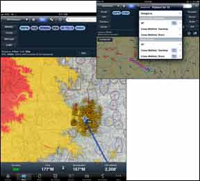
ForeFlight’s new Hazard Advisor is a terrain and obstacle awareness system that highlights hazardous terrain and obstacles, based on the aircraft’s GPS altitude. We tested the terrain feature using position acquired from the Bad Elf Pro remote GPS receiver and noted accurate terrain painting. The obstacle warning is dynamic, meaning terrain and obstacle features seamlessly appear on screen as they become threats, in real time.

The terrain function uses familiar terrain alerting colors—with terrain and obstacles within 100 feet presented in red—while hazards within 1000 feet are colored yellow.

VOID-FREE TERRAIN
ForeFlight notes that not all terrain data is created equally, and it’s the terrain data sourcing that makes the difference. For example, free data sets used by some applications have voids that miss important features— like mountain peaks, for example.

But ForeFlight’s terrain database is void filled, which adds a higher level of terrain contour accuracy. Appareo Systems—the makers of the portable Stratus ADS-B receiver—provides the terrain data for the ForeFlight Mobile 5. Appareo corrects the terrain data void to ensure that the missing terrain is actually represented in the terrain data set.

Appareo’s worldwide, three-arc- per-second terrain database was produced by NASA during its Shuttle Radar Topography Mission. The end result is a terrain data specification that’s of higher resolution than the data used in most Terrain Awareness and Warning Systems.

Traffic Pattern Advisor
Need some help maneuvering into the airport traffic pattern? The app’s extended runway centerline feature—which helps visualize runway layouts when approaching—can help.

This smart function helps you select runways based on wind data, and then helps select the appropriate runway entry pattern. Pattern entry options include straight in, 45 to the downwind, crossing midfield with a teardrop entry, and crossing midfield with a direct entry for both standard and right-hand traffic patterns. The default pattern direction for a given airport is also displayed.

The runway winds feature graphically shows the headwind and tailwind components, so you can better select the correct runway when your favorite control tower closes.

Foreflight added options for map orientation, offering the choice to select track up or north up. In fact, there are two track up modes: track center and track forward. In track center mode, the aircraft is positioned in the center of the screen, while track forward positions it lower on the screen. When you approach a terminal area, the Auto-Taxi system is armed. When the aircraft’s speed drops below 40 knots, the airport diagram is automatically loaded and displayed in the apps Plates view.

ForeFlight Mobile subscriptions start at $74.99 per year, downloaded from iTunes. There’s also a 30-day free trial. Visit Foreflight.com.

Editor in Chief Larry Anglisano has been a staple at Aviation Consumer since 1995. An active land, sea and glider pilot, Larry has over 30 years’ experience as an avionics repairman and flight test pilot. He’s the editorial director overseeing sister publications Aviation Safety magazine, IFR magazine and is a regular contributor to KITPLANES magazine with his Avionics Bootcamp column.