Garmins 295

Vivid color, intelligent operating logic and an improved GPS engine make this one a winner. But dont plan to run it long on batteries.

Is there anybody alive who doesnt have a portable GPS moving map yet? Okay, so maybe youre a Ralph Kramden fan and youre waiting for the 3D model with accompanying decoder ring.

Garmin hasnt announced that model yet but we sometimes get the impression theyre about to. In the meantime, the company is finally shipping something that comes close: A portable moving map GPS with color that rivals Garmins GNS 430 panel mount.

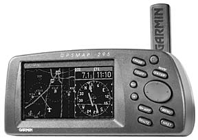
At a glance, the GPSMAP 295 looks like an inflated version of the GPS III Pilot, another popular Garmin product. Like the Pilot, the 295s screen orientation is horizontal or landscape, the buttons are on the right and the antenna pokes up from the backside.

But apart from operating logic, thats the extent of the similarity. In our view, even if the 295 had no color, it would represent a step-up from Pilot and Garmins previous top seller, the 195. The 295 is easier to operate, has a faster processor and a land database capable of finding every flyspeck on the planet.

Wow, Color
Screen size is critical to how a moving map reads, and the 295s is generous. The screen is larger than the Pilot model and about the same size as the 195. The landscape or horizontal mode allows for better presentation and less clutter at low zoom scales, thus the screen is more map like. The color screen itself-eight colors-can be adjusted through the power button. Pressing the button once brings up a brightness and contrast menu, which you can adjust with the rocker keypad.

Another press enables night mode, which switches the basemap color from yellow to black. Another press circles back to day mode. This return-to-start control logic is followed throughout the GPS 295 and we found it worked well. And how about the color? Its vivid and crisp and bright enough for normal viewing, but it tends to wash flat in direct sunlight, although it remains viewable. Although the 295 doesnt seem noticeably dimmer than its big brother, the GNS 430, the 430s additional screen brightness blasts right through direct sunlight. Not so the 295. Even the 195 does better in sunlight but, on average, the 295s map details are easier to see.

But really, isnt the color just another gimmick? Not really. Highways are in red, water blue, the background in yellow, making the map decidedly more readable than the 195 and delineating detail nicely. As you zoom in, more detail emerges, including airport runways with numbers in proper orientation, plus more information on ground detail, such as highways and the like.

Too much clutter? Press the enter key once to lose the highways and minor land detail, again to dump airspace depictions and minor geographic detail. A third press strips the map to just route waypoints and general geographic information, while the fourth press brings everything back.

Power Up
One nice feature of the 295 is the switch from external to battery power. While we like the fail-safe mode of the 195 when external power is lost, weve trashed the batteries more than once after having turned off the master but not the GPS while running on ships power.

The 295 fixes this shortcoming. When external power is lost, a message asks the user to punch any key to continue on battery power. If you dont respond within 30 seconds, the unit shuts down automatically. And trust us, you will be using ships power. On battery alone, the screen automatically dims to conserve power and in daylight, you need all the brightness that you can get. The manual says six AAs will last about 2.5 hours. Our test model did better than that-about four hours.

Still, youll go through a sack of batteries in a day of flying if you dont use aircraft volts. A big improvement over the 195 is the integrated battery compartment, which is easily accessible under a cover with a quarter-turn fastener.

Another improvement: The cigarette lighter adapter is now separate from the yoke mount, so no more surgery on the mount to remove it. Garmin also ships a data/PC cable for database and software upgrades standard with the 295 and as we went to press, version 2.01 of the software was already available on Garmins Web site.

During our week of trials with the 295, we didnt have an external antenna-the 195 external antenna cant be used-but had no problems using only the on-board stick antenna. The standard remote antenna is a patch-type active design, which sits on the glareshield or could be mounted externally, if desired.

Odd Little Piker
The 295 is smaller than the 195 in both length and width but not in depth. The 295s overall size and feel is a bit awkward, actually. It has a CG problem. Forget propping it on the co-pilots seat or on the glareshield. Even with a Velcrod bean bag, it wants to roll over on its back like a dead bug. You need heavy duty Velcro and a folded, wedged chart to make it work.

The yoke mount is standard and will be needed in most aircraft, we predict. Because of screen brightness limitations, viewing angle is somewhat limited and the yoke mount should help with that, too. Overall operability has been improved in the 295 and the 195 was no slouch to begin with. Theres a pair of zoom in/out buttons for map scale changes in place of the 195s single button, an improvement we applaud. The 195s go-to button has been replaced by the more useful route button. Pressing it brings up stored routes, which is friendlier than having to step through a menu.

In general, buttons are arranged in a more logical fashion than they are on the 195, with easier finger movements based on what you typically need to do. Once powered up and past the death-and-destruction liability page, the navigator finds itself, and we mean quickly. Thanks to a faster processing chip, its ready to play in less than a minute.

Pages
The 295 displays these pages: Sat Stat, Data, Map, HSI and Active Route, with the map page doing the heavy lifting. We typically use a mileage zoom of 12 to 20 miles on the 195 when threading the thicket around New York. But selecting the 5-mile scale on the 295 shows the equivalent detail and look ahead capability. Map refresh speed is quite fast, again due to the improved processor.

A noticeable improvement over the 195 is the use of small informational messages that tell exactly what you need to know about airspace alerts and so on, without having to toggle to another page.

Without a special data card, the minimum scale is 5 miles on the 295 versus 20 miles on the 195. Selecting a scale less than 5 miles results in the word overzoom under the mileage scale. Overzoom means that youve selected a scale that will yield less detail than the units database can supply.

Garmin has a solution for that, too. Using the experience gained in designing the Street Pilot for the SUV crowd, Garmin has integrated land and aviation data. The 295 has a land mode on the system set-up menu, thus you can establish criteria for the 295 that applies when driving versus when flying. For example, map criteria for airspace can be disabled in land mode. Conversely, you might decide to disable certain land data when flying. The two modes provide their own stored settings so you dont have to constantly change back to something you found useful when flying but not when driving.

The demo unit we flew had the optional MapSource land data for the New York Northeast and Southwest quadrants. This is an optional database that slips into the back of the unit on a 16MB flashcard and is the fruition of a big investment Garmin has made in its own cartography department.

MapSource comes on CD and is uploaded from your PC into the 295 using the supplied data/PC cable; no data card burner required. The coverage area appears as an orange box when viewed on the map page at the appropriate mileage scale. Cost for MapSources Metro Guide for the U.S. is $250, to include the CD and an 16MB card. ($50 less buys an 8MB card.) Other land data options are also available.

Not only is the resolution fantastic, particularly when coupled with color, but you can look up various points of interest (POI) such as food and drink, gas stations, ATMs and the like. Enter a street address as a waypoint -useful when trying to find and then circle your friends house-or enter a crossroad if youre not sure of the exact address. Thus is born situational awareness for your car and the end of having to bug gas station attendants for directions.

A to Z No More
Waypoint access has also advanced from a simple airport look-up. The 295 has an intelligent search function. With the 195, each press of the rocker keypad selected the next/previous letter or number in logical fashion. While it may have been logical it wasnt fast. Why sift through the alphabet when the Jeppesen database already knows that only nine legal combinations remain for airports beginning with KCD? This feature makes selection of airport IDs and waypoints simpler and faster.

One nit we have is the address waypoint selection. Here, the intelligent selection feature is cumbersome, because the unit creates possible waypoint lists while you press each keypad button. We would prefer that the software consider the rate at which the user is pressing the button and dispense with list creation until the keypad button is no longer being pressed. You can select from information that includes airports, runways, frequencies, approaches, user waypoints (up to 500 can be stored), cities and exits (yes, exits, as in highway exits). With MapSource loaded, you can further select POI, address and crossroad waypoints. As a test, we drove to several waypoints involving both small roads and major highways. The accuracy was flawless, although at the lower mileage scales (around 800 feet) the track dots didnt quite line up on the road. Gilding the lily in typical Garmin fashion, you can customize this thing galore, losing yourself in personalized screens. All menus are context-sensitive based on the page youre viewing when the menu button is pressed.

If youre on the map page, pressing the menu key pulls up a customization menu for the map page. You can select a variety of data fields with or without an HSI, which can then be displayed on the map page where you want them.

The customization menus are configured as tabs or property sheets (for the computer literate). On many of the customization tabs, youll find a mini-map that depicts the waypoint or map feature you may be changing. This lets you see the change youve made while still within the menu system, which the 195 couldnt do. Again, use of color makes this feature useful.

The HSI page is similar to the 195s. By default, eight data fields are displayed next to the HSI, but these can be customized to suit. One thing missing in the 295 is a separate trip and planning function, which the 195 has. This function can be simulated in the 295 by entering a route and setting a fuel flow. Once you enter a route, you can activate and fly it and/or select an approach in flight.

As with panel mounts, the 295 allows specifying vectors to final, which prevents it from auto sequencing to the next waypoint or approach fix until youre on final. In other words, this thing works a lot like a TSOd panel mount approach box.

The 295, like the 195, allows panning of the display, meaning you can push the cursor out ahead of the airplane to see whats ahead. And the 295 will identify just about anything out there, including roads, rivers, lakes, ponds, airspace limits and so on. You can obtain more information about these features by just pressing the enter key.

A minor wart: Its almost impossible to view airspace limits if theres anything but water beneath the cursor. The 295 will display what youre pointing at to a drill-down level bordering on the absurd. For example, point at JFKs southern airspace and youll likely get an Ocean Parkway tag.

Some Piece of Work
Lots of companies talk a good game but Garmin seems to consistently execute on their designs, producing GPS equipment thats a cut above the competition. In our view, theyve outdone themselves on the 295.

Its not the first color GPS moving map, but it very well might be the best. Oddly, its not the color that makes it exceptional, in our estimation. The 295s predecessor, the 195, became a best-seller for a reason: A combination of strong features, not the least of which was good operating software.

We suspected some improvement was possible but the 295 advances operability across all fronts in ways that show the engineers really thought this one through.

The color is nice, yes, and well integrated into the design. But in our opinion, the 295 would nearly be worth its $1449 asking price even without the color. When the 195 debuted, it sold for about $1200. Given the 295s color display, performance and improved features, the extra $249 over that price is a more than fair value.

Recall that the 195 supported extra map detail via cartridges, a feature that never really panned out. But the 295s MapSource database and data card are intriguing and the flexibility of loading regional information may very well turn this navigator into the multipurpose GPS Garmin envisions.

Bottom line: This thing is a winner and well worth the asking price. We have no reservations in recommending it.

Contact-Garmin International, Inc.; 1200 E. 151st Street, Olathe, KS 66062; 913-397-8200 or 800-800-1020; www.garmin.com.


Also With This Article
Click here to view the Garmin 295 Checklist.
Click here to view the Portable GPS Comparison.
Click here to view “A Color Map: How’d They Do That?”

-by Ben Rosenberg

Ben Rosenberg contributes frequently to Aviation Consumer. He is a software mogul and owns a Mooney Ovation.