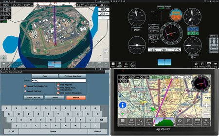
From upper left: A screenshot of the iFly RealView imaging feature displaying a satellite view of Hartford Brainard Airport in Connecticut. The course line shows navigation to the center of field. This utility makes it easy to find an unfamiliar airfield, in our view. Basic round-gauge instruments, including HSI, groundspeed and GPS altitude are highly configurable. Pitch and roll data can be displayed on a round-gauge horizon display with an appropriate AHRS input. The square to the left of the groundspeed indicator is a traffic alert box, for displaying ADS-B traffic data. Chubby fingers will get along we’ll with the onscreen keyboard. It is used for entering flight plan data and for searching waypoints. The iFly GPS app shares the same feature set and graphics as the iFly GPS 720, and the improved iFly 740 dedicated tablet navigators.