by Frank Bowlin
Although were a long way from a computer in every cockpit, tablet PCs and PDAs-personal digital assistants-are finding plenty to do in the world of light aircraft GA. When they first appeared more than a decade ago-remember Apples ill-starred Newton?-PDAs werent even called PDAs and the market was limited to the pocket protector crowd.
Not anymore. PDAs have become ever more capable and the number of aviation-specific PDA applications has exploded. Significantly, the worlds dominant avionics manufacturer, Garmin, has a Palm-based PDA and it recently introduced the first aviation-specific model, the iQue 3600a, to compete with products from Control Vision, AirGator and other plying the palmtop subgenre.In the February 2005 issue, we examined the more capable flight calc, planning and E6B-type applications for PDAs. In this article, we’ll look at navigation and moving map programs for palmtops and, in subsequent articles, we’ll keep track of future developments.
First, a disclaimer: Our coverage doesnt include every piece of hardware or software application available. Frankly, there are too many of them to evaluate and we consider market interest in these devices to be limited. For a more complete listing and summary, see www.palmflying.com, an excellent resource with useful detail on both Palm and PPC applications.
Two Platforms
As we explained in our earlier report, the PDA world is dotted with a cottage industry of software providers. Some of the software is free, some of its cheap and some of it rivals both the price and capability of applications written for desktops. In case you cant read between the lines, we’ll fill in: software providers may come and go, so keep that in mind when selecting a platform or an application. The major providers such as Control Vision and AirGator appear to be long-term players.
If youre new to PDAs, bear in mind that just as in desktop computers, there are two incompatible platforms. The Palm operating system from 3Com, now the spun-off palmOne, was the first to thrive with what was originally called the Palm Pilot, now commonly called Palms. Many manufacturers, including Garmin, sell Palm-type hardware.
Microsoft jumped into the PDA market with Windows CE, now called Windows Mobile. The iPAQ from Compaq, now absorbed into HP, was the first popular Windows CE device. These devices are usually called PocketPCs or simply PPCs. In general, the more ambitious programs are designed for PPCs but there are exceptions to that. We recommend that you make a platform choice based on the available software for your own needs, bearing in mind that you’ll use the PDA for non-aviation tasks, too.
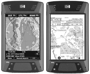
To trial Palm software, we used an earlier model iQue from Garmin, a PDA with a built-in GPS and city mapping software thats useful when driving.Except as noted, for the PPC software, we used a cutting-edge HP iPAQ hx4705, a fast-processor PPC with four times better display resolution than older devices thats just now finding its way into the market.
Anywhere Map/PPC
Control Vision is the big kahuna in moving maps, as much for their marketing as for their products. They offer a complete suite of products including Anywhere Map, Anywhere Wx, Pocket Plates and Anywhere AI, a solid-state gyro presentation. Since all these products hinge around the central Anywhere Map, thats what weve reviewed here.
First, Control Vision, like AirGator, offers complete systems and has custom-built cables and bracketry to minimize the cable spider web and mounting problems, a real plus. We tested Anywhere Map using an HP iPAQ h5555, a capable PPC, but one that lacks the faster processor and higher resolution of the hx4705. Performance was a bit slower but should be excellent with the faster processor. The display was quite adequate for this version (V1.6), but Control Vision is working on an upgrade that will take advantage of the high-resolution screen.
Although you can go directly to the map display, its useful for any moving map to have a flight plan which Anywhere Map makes relatively easy with a waypoint lookup device called Universal Finder. It generates a list of recently accessed waypoints or the nearest waypoints. If the desired waypoint is one of the few shown, just select it. If not, start typing and there’s an auto-complete that finds waypoints beginning with the letters youve already entered.
Its seldom necessary to enter more than a couple of letters to find what you want. Input is done with a stylus via a pop-up keyboard along the bottom of the screen which is actually two halves of a single large keyboard that requires you to switch back and forth to use all the characters. You can also add a waypoint to your flight plan by double-tapping it on the map. Of course, flightplans can be saved or retrieved.
The map includes everything you might want, including some geographic data and most aeronautical data, including airspace depictions. The standard view places your aircraft in the center of a compass rose with the desired flight plan course line drawn. The typical data-speed, distance, altitude-is also displayed and there’s even an automatic flight timer. You can optionally display an HSI with user-settable OBS, instead of the OBS being slaved to the next waypoint. Map quality is good and will improve as the maps are optimized for the higher resolution of the newer PPCs. The level of displayed topographic detail falls short of MountainScope, but is quite good. An important feature is the ability to color-code terrain based on relative altitude, showing potential terrain conflicts and simulating a TAWS set-up but at a fraction of the cost.
As you would expect in a program of this caliber, there’s a full database behind it. This one is more complete than most, including information such as car rental, hotels, restaurants and so on, all easily accessed with a double-tap on the map or from the Universal Finder.
There are a plethora of additional useful functions, such as emergency mode, auto-zoom, VNAV and E6B functions. One more feature deserves mention: the Virtual ILS. Anywhere Map will provide navigation via a pseudo-ILS to any runway. Using GPS altitude and position data, its simple to calculate a constant slope and course to a specific point. Simply select the end of a runway, set it up and youre on your way. We would never use this in IMC for anything other than an emergency, but its an interesting feature that will allow you to amuse your friends by flying a simulated GPS precision approach we’ll in advance of the availability of the real thing.
Anywhere Wx integrates nicely with Anywhere Map. The weather information is available via either WxWorx/XM Radio or Globalstar. Although we like the idea of a general purpose bi-directional device like the Globalstar satellite phone, the market has overwhelmingly chosen the XM option for its speed and robustness. Using AnywhereWx, you can view NEXRAD and lightning superimposed on the map; text METARs and TAFs are also available.
Like most capable moving maps, Anywhere Map is not a program you can turn on and use without documentation. We know because we tried. Operation isn’t difficult, but neither is it completely obvious until youve used it. Control Vision has assembled a capable, well-thought-out set of products integrated for practicality in the cockpit. As shown in the chart, these products arent inexpensive, but in our view, they represent excellent functionality for the money.
FlightMaster/Palm
FlightMaster is a companion program to CoPilot, which we reviewed in the February issue. You use CoPilot to enter the basic flight plan, then FlightMaster uses that for the moving map. The HSI page in FlightMaster provides interesting additional information, including a bar whose size and orientation-up or down-indicates vertical speed. Turn rate information is displayed by colored arrowheads pointing in the direction of the turn, one green arrowhead for 0.5 degrees per second, two for 3 degrees per second and so forth. This adds up to an impressive HSI display, in our view.
FlightMaster provides a basic moving map with the features youd expect.You have a full flight plan from CoPilot, nearest information, waypoint data and HSI and moving map. The map is rudimentary in that there’s no land or civil data, just aviation data such as airports, navaids and intersections, so its not for sightseers. But its useful to help you get where youre going. Unlike many of the other programs, the HSI page is separate from the map; there’s no superimposed compass rose on the map, only your flight plan course line and current track line.
FlightMaster also includes what it calls an attitude approximator, which simulates an attitude indicator using only GPS data. Garmin popularized this function with its GPS 196 handheld and it works we’ll enough to furnish meaningful back-up when all else fails. As with the Garmin, we recommend that you practice with any GPS-derived attitude device with a safety pilot aboard before subjecting yourself to a flight where you might have to rely on it to save your bacon.
GPS Pilot/Palm
This is a basic, no-frills program. Although the Web site doesnt mention it, we were pleasantly surprised to find support for the Garmin iQue. To use it, you first enter aircraft performance data, wind and your route. GPS Pilot calculates your headings, times, fuel and other parameters, just like any leg planner. You can then view a GPS-driven moving map with your course line to track your progress, the essence of required functionality for this kind of program.
The maps are raster-scanned images, thus they arent crisp at zoom levels closer than the original. By contrast, maps on a typical handheld or panel mount and the other programs reviewed here, are generated by the computer from raw data. Consequently, when you zoom in for more detail, symbols and text remain crisp and of the same relative size. Scanned images are readily available, however, and can be useful if you select your zoom level carefully. You can, for example, follow your progress directly on an image of a WAC chart. At only $69.95, GPS Pilot does a lot for little money.
MountainScope/PPC
Stunning. Thats the first word that comes to mind when looking at MountainScopes maps. The finely detailed topographic shading makes the maps look more like satellite photos. The higher resolution VGA screen on the iPAQ hx4705 produces truly startling map clarity and detail, even zooming down to a 4-mile scale. The jaggies from pixilation arent a problem until the 2-mile scale is selected. The map is so good that when we zoomed in that close, we were a bit disappointed not to see buildings, as you would in a real photograph. Its that good.
While the moving map is MountainScopes strong point, navigation and flight planning are not. Its easy to enter a flight plan, but there’s no distinction between what youre flying and your flight plan, hence, there’s no concept of direct-to.
MountainScope displays a compass rose and course lines on the map, so when comparing against your present position, its simple to see where you need to go. The display also has colored bugs around the compass rose to show the way to various points, such as next waypoint, nearest airport or navaid.
MountainScope also supports external gyro input from the pcFlight Systems e-Gyro and weather via WxWorx, but we didnt test these. (See January, 2004 Aviation Consumer for more on the e-Gyro.) An interesting feature of the gyro pack is that it enables a synthetic vision display showing a look-ahead view of the terrain, just as if you were looking out the window. This feature is currently available only on the PC version, but MoutainScope plans to add it to the PPC when the operating system support matures.
Although lacking in navigation flexibility in the current version, we would expect MountainScope to evolve into a powerful, useful package.
NAVAir/PPC
NAVAir, from AirGator, has evolved into a full-capability product line offering an impressive moving map and now, weather via WxWorx and, just recently, approaches. AirGator is one of the few vendors to offer full packages of hardware and software, plus custom cables that combine both power and data to reduce the cable mess.
All of the vendors use the same WxWorx receiver, the differences are in how that receiver is connected to the PPC. AirGator allowed us to preview a prototype unit that looks externally like the standard WxWorx receiver.However, inside AirGator has grafted a Bluetooth wireless communications module. On the surface, that would seem like good news and it is.Unfortunately, the iPAQ hx4705 only supported one Bluetooth connection at a time when we reviewed it, so it wasnt possible to use both a Bluetooth GPS and the Bluetooth WxWorx receiver. By press time, AirGator told us they had solved this problem so its now possible to use your PPC wirelessly, with a remotely located GPS and the remote WxWorx receiver.
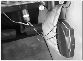
We should note, however, that power is still a consideration for all PDAs. Battery life for PPC is a concern and the GPS and WxWorx receiver still require ships power, plus a remote antenna. No matter what, you cant escape the wiring hassle entirely.
NAVAirs documentation is the most complete and detailed of any weve seen; you can preview it on-line to get a feel for it. NavAirs map is typical of a quality moving map, depicting geographic features such as water and political boundaries, plus speed, distance, altitude, aviation waypoints and other detail. Its unique in that it uses the entire screen to display the map. Anything that pops up and superimposes on the map is transparent, including command buttons and waypoint data. Nice feature. Further, in addition to the standard compass rose, you can display a horizontal heading tape instead.
You can set standard map de-clutter options based on zoom range and even map themes that allow you to ignore geographical data, as you would on an IFR chart. The maps also depict airways, a detail not all moving maps have.
As youd expect, flight plans can be easily created, stored or recalled and flown with course lines on the map. One nice feature of flight plan entry is the ability to quickly enter a flight plan simply by entering the waypoints in a single line, just as you would on an FAA flight plan form.Finding waypoints for a flight plan or other purpose uses an auto-look-up feature. You type the first few letters and NAVAir attempts to find what youre seeking, a feature similar to but not quite as powerful as Anywhere Maps Universal Finder.
Tapping on a waypoint pops up a small data block about that waypoint with minimal information; detailed information is available by tapping that data block. There’s no specific area of the screen for the data blocks; they pop up close to the waypoint. This enables another nice feature: Each waypoint you tap pops up its data block independently of the others and you can have as many blocks open at once as you can stand. You can erase the blocks on command or wait 30 seconds for them to disappear on their own. Since the blocks are transparent, the map is never completely obscured.
NAVAir offers all the normal text and superimposed graphical weather functions and this completes a capable moving map navigator. Finally, AirGator recently added NAVAir Approaches, a feature we didnt test.
PocketFMS/PPC
Were mentioning PocketFMS, however, we didnt conduct a full review for several reasons. One, we were interested only in standalone programs and although PocketFMS does operate on the PPC independently of the full PC version, it requires the PC version to acquire its data. Second, although capable, PocketFMS was the most difficult to learn to operate, partially because of its distinctly international focus. The good news is that PocketFMS is available to try without cost or restriction. If youre willing to explore unfamiliar territory and deal with a powerful but challenging-to-learn program, by all means give it a try.
Recommendations
Much of the software mentioned here is available for trial download. If you think you might like to use one, download the trial version and give it a go. If you don’t like it, delete it and try the next one. If you like it, buy it.
Most of this software costs less than a couple of tanks of gas, so there’s not much risk in buying one that you later outgrow. As for platforms, we favor the PPC over the Palm because, in our view, the PPC offers more functionality than the Palm, beyond aviation applications.
For pure map software and display pizzazz, we were most impressed with MountainScope, simply for the map quality. It truly has to be seen to be believed. Were betting on MountainScopes ability to enhance the product with more functionality, specifically flight planning and navigation. Given its high price, MountainScope is at a disadvantage without extensive flight planning and better navigation features.
If these are top requirements for you, the Anywhere products from Control Vision and NAVAir products from Airgator offer more complete and better integrated packages. Wed give a slight edge to NAVAir because we liked some of its mapping features a bit better than Control Visions and the user interface was easier to decipher. On the other hand, Control Vision offers easier-to-understand hardware bundles, a slick Web site and excellent technical support.
We think most users would be happy with either vendor, provided the general limitations of PDAs-screen size, wiring hassles, sunlight readability-are accepted.
Also With This Article
“PDA Software Compared”
“The Bluetooth Cockpit”
-Frank Bowlin worked in the computer industry before becoming a pilot for a regional airline. He lives in California.