Paperless Cockpit Redux: iPad a Best Bet For Now

No, the iPad doesnt do it all and isnt for everyone. But for the fat middle of the user bell curve, it delivers the most utility and best experience.

Before the fan-boy and anti-fan emails start pouring in, lets get one thing clear: Were pegging the iPad as the best bet for most pilots for replacing paper charts and approach plates in the cockpit. This is not a surprise with a device designed for reading stuff comfortably.

Weve said before and were saying again: If you want advanced functions-GPS

288

navigation, TAWS, on-board weather, or even some kinds of interactive documents-then the iPad may let you down. Most importantly, it may let you down unexpectedly, as with the iPads GPS that works great, except when it doesnt. There are at least two external GPS units for to the iPad, but we havent tested them.

If your needs extend to those other functions, there are other more robust and versatile options. There are also cheaper options if your budget cant justify an iPad. And even using the iPad, there are several options for view charts that offer different capabilities and cost.
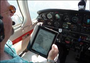
iPad Sweet Spot

What the iPad does well it does phenomenally well. The physical device is simple to use: A button to turn on, a tap to launch your chart reader, and a suite of taps, flicks and pinches to select, scroll and zoom. Weve watched pilots who we know struggle with navigating even a Garmin GPSMAP 496 whip through the iPad with ease.

The screen is also super-sharp and color. Anyone with enough vision to fly can read an approach plate when it fills the screen. Most eyes can even read it at half that size, as happens in the split-screen mode some apps offer. With the 9.5 by 7.5-inch iPad in a grippy sleeve on our lap or in one of several kneeboard and mounting solutions, its easy enough to use in the cockpit.

The screen has a significant glare in the daytime and can be too bright at night (although switching to an inverse view helps). If we could wave a magic wand, wed want an iPad that was just a bit smaller. The touchscreen is also limited when it comes to jotting down information. Freehand writing with your finger is possible, but neither comfortable nor clean. Dont count on the battery life; weve found 24-volt to USB power adaptors for under $5.

While you can pay to play at $499 for a 16GB unit, we think you want to go at least to the $629 16G/3G model to get the internal GPS (or look at one of the external GPSs that connect). Even the mediocre internal GPS will almost always place you on a chart close enough to get you in the right part of the sectional chart or the airport diagram. The GPS also makes preflight planning much easier, as the radar or METARs youre reviewing on the ground are relative to your location. In our testing of the iPad, its utility for flight planning in the FBO, particularly for weather, was a huge plus. There are cool tricks these apps can play, too. Enter your clearance with airways “ENE V3 CON …” and the app decodes it into waypoints to put into the GPS. The other great plus about the iPad is that download management is built in through WiFi. Tell the app to update your charts

288

before you go to bed and it does the rest-no datacards, no website downloads.

How much you want to lean on the iPad GPS in flight will probably influence your app choice. We still think the two contenders worth trying are ForeFlight and WingX, at least for North American flying (try Air Navigation Pro for some European charts). No other apps but none have the utility and reliability of these two, as we see it.

Our testing supports ForeFlight being easier to use than WingX, and it clearly excels on preflight weather (including international weather), integrating this weather over a map, but not the scanned charts. ForeFlight offers sectional and en route charts, with your route and position shown. You can easily pinch to zoom and scroll. ForeFlight just improved their system to allow rubberbanding and editing of routes right on the screen, as well as a much-needed direct-to function.

WingX is designed more like a portable aviation GPS, with a data-derived moving map capable of showing terrain and customizable to show only the items you want. It just added scanned charts and pinch to zoom. It also has a clever split-screen setup to show an airport diagram or approach and a chart simultaneously (ForeFlight lacks a quick toggle between these views). WingX is better at getting information off the map for points not in your flight plan. It can also give you detailed information on items like airspace directly rather than zooming in to read it off the chart. The split screen showing your position on the map and the approach plate simultaneously is a plus.

We tended to prefer ForeFlight in the FBO, but WingX in the air, particularly in aircraft that have no other GPS. (Even a so-so GPS is better than none at all.) That said, the apps are constantly being improved. ForeFlight has a three-month trial plan for $24.99 or a year for $74.99; WingX requires you try the full year at $99.95. We know several pilots who pay for both, to get the best of each. Both systems offer bonus data, such as AOPA airport information, current fuel prices and more. WingX offers georeferenced approach charts (the aircrafts position on the approach), but thats an extra $199/year.

These arent the only two options. Beacon by Zivosity has promise (and has sectional and en route charts), FlightPrep has iCharts (approach, sectional, en route and TAC, but no GPS support) and Garmins terrific PilotMyCast will be released for the iPad and will have approach charts. If you have a Jeppesen digital chart subscription, you can download a free iPad reader for your Jepp plates on your iPad. But thats all it does: display approach and airport charts.

Cheaper Readers

You can can shave some cash by still using the iPad but rolling your own charts. PDFPlates.com offers whole sections of the country in PDF format for donation. PDFs of sectionals or en route charts can be had from SkySectionals.com as one-time purchases or by subscription. But we think the management of these solutions is penny-wise, pound-foolish given the ease and value of something like ForeFlight.

288

Weve looked Sony and Kindle solutions in the past (see March 2009, August 2009 and March 2010). PDFPlates offers files (free or for donation) that work on KindleDX and Kindle2 as well as the Sony digital readers. Readerplates.com offers files for the Sony readers and KindleDX for $9.99/month. Airbrief.com costs $9.99/month for the KindleDX and Kindle.

While these readers have the advantage of running for days between charges, we cant recommend investing. In less than 12 months weve gone from searching for the right kind of plate reader to something that only does approach charts not being worth the trouble, unless you already own the hardware.

If you already own an iPhone or Android, you might consider WingX or ForeFlight on the smaller screen. Its harder to read, but you get most of the iPad features without the hardware investment.

Tablet Solutions

There are Window-based computers that can fold up such that they are a tablet you can hold in your lap or in a mount, which we reviewed in our April 2010 issue. Our top picks were Flight Preps Chart Case and the Voyager Skypad2. AnywhereMaps Duo is also a contender.

Tablets are similar to the iPad in that they have touch-sensitive screens, but they often also offer a stylus for better writing. They connect via Bluetooth or cable to an external-and reliable-GPS, as well an optional XM receiver or even Zaon traffic sensor. The result is more like a portable MFD than a simple chart reader. As its a full-up computer with a fold-away keyboard, it can also be used for e-mail, document management and anything else you might need on the road.

We found the tablet solutions have more powerful viewing options. For example, you can customize split screen views more completely than on iPad apps.

If you want approach plates and sectional/en route charts but also want datalink weather and powerful flight planning tools, then these devices might be a better bet. They will cost you more than the iPad, however, running $895-1796 for the devices plus $299-350/year for the data subscriptions, or more with XM weather. These things are also heavier than an iPad, and consist of several pieces with power cables or batteries to recharge.

Jeppesen Users

The tablet computer is also the hardware end of Jeppesens paperless solution for GA: FliteDeck. Wed give Jeppesens FliteDeck software a seven on a scale of one to 10 for overall usability. Its a powerful moving map and display system. It shows all the Jeppesen approach charts your subscription covers, as well as en route maps that are similar too, but not exactly the same as Jeppesen low or high charts. It also has a VFR view that is similar to a sectional and the Jepp textual information youd get with an paper subscription.

The learning curve is a bit steep for the software, and you still have the cockpit clutter of a separate GPS and power supply, but the system does work as

288

described. XM weather is available if go get the receiver. Jeppesen doesnt offer the hardware, so youre on your own to put that together as well. Jeppesen, and several other vendors for that matter, also offer higher-end EFBs aimed at corporate and commercial aviation.

If you just need Jeppesen approach charts, try the SOLIDFX FX8. The reader is similar to the Sony or Kindle in screen technology and battery life, but the similarities stop there. The software to organize and display the plates is exceptional. The FX8 requires a stylus (no touch sensitivity) but that lets you write down notes with near pen accuracy and fill out forms.

Jeff McDonald of SOLIDFX says some of their clients use the FX8 for document management more than as a chart reader. The FX8 is also the perfect size, in our view, at 7.6 by 5.9 inches. There is a bigger FX10 version. The FX8 is $1195, plus whatever subscription you choose for the Jeppesen approach charts.

Looking at the FX8 on our chart to the left, it clearly lacks extras that other solutions offer. We think thats mostly a limitation of the iRex reader SOLIDFX uses. Wed like to see SOLID FX offer an iPad solution themselves that took their clever organization to a more versatile platform.

Aviation GPSs

If our top-pick iPad is the chart reader that makes a pass at being a GPS, then we have to look at real aviation GPS units that also show charts. We think three rate: the Garmin GPSMAP 696 (October 2010), the Honeywell AV8OR Ace (October 2009) and the Anywhere-Map Quadra (June 2010).

The least capable as a chart reader is the GPSMAP 696, showing only approach charts (soon to be georeferenced) and an en-route-chart-style moving map. Both the AV8OR Ace and the Quadra show georeferenced approach, sectional and en route charts. The Ace is bigger (seven-inch screen) and can show the whole chart at once. The Quadra is smaller (4.3-inch screen) and requires scrolling, but the screen is quite sharp. The Quadra also has WiFi data download.

The Garmin is a pricey $2999 plus $700/year for full data. The Ace is less at $1799/year, plus $399/year for U.S. data and $799 for European data. (You read that right. European charts and approach diagrams.) The Quadra is a bargain $595, plus $260/year for the data subscriptions.

iPad Fan Club?

It somewhat pains us to feel were joining the iPad brigade, but when the mission is viewing digital versions of what we used to lug along as paper, the iPad simply does it best. WiFi/3G and the (mediocre) GPS take it a step beyond paper into a real preflight and cockpit tool.

The next generation iPad or Android tablet might have the horsepower to drive a real GPS and datalink weather (XM or ADS-B). Until then, we think most pilots wont regret for a moment buying an iPad and tossing the paper in the recycle bin.