Ryan Goes Graphic

Teamed up with Argus, Ryans TCAD can now display traffic on a moving map, giving Goodrichs Skywatch worthy competition.

As pilots, we all want to decrease risks. In some cases, that can be done by buying sophisticated equipment, such as a sferics device, radar or improved seatbelts.

Until very recently, gadgets to reduce the risk of a midair collision have been out of reach for most aircraft owners, primarily due to cost. The typical airline TCAS (Traffic Collision Avoidance System) costs from $50,000 up to more than three times that, making it a top-heavy investment for light aircraft owners.

The low-cost alternative-the Ryan TCAD-helps. But until recently, it lacked one very critical bit of information: azimuth. With a TCAD, you can tell when traffic is out there and how high it is relative to your own altitude, but you cant see where it is, electronically speaking.

Recently, Ryan has teamed up with Eventide, maker of the popular Argus moving map products, to build a collision avoidance device that graphically displays traffic threats.

The new Ryan 9900B/Argus competes directly with BFGoodrichs Sky Watch system, which projects traffic threats on a WX-1000 Stormscope display. Lets examine how the systems compare. But first, lets put the bottom line at the top. Goodrichs Skywatch system will cost about $19,800 for just the hardware, assuming you already have a WX-1000+ Stormscope. (Prices vary; depending on the shops discount, that total could also include installation or figure on about $2000 for installation.)

If you dont have the Stormscope, installing both the weather mapping and Skywatch functions of this system will total about $32,000. If you want just the traffic function, not weather mapping, the cost will be about $24,000. By comparison, the basic Ryan 9900B-which alerts to traffic and displays a simple arrow on the panel-mounted box to show azimuth-costs about $15,000 for the hardware, plus installation.

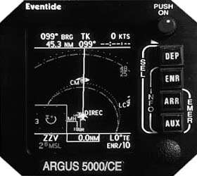
If you already own an Argus moving map (5000 or 7000 series, color or late-generation monochrome), you can couple the display to the 9900B to graphically display traffic for the cost of a $500 software package, plus minor wiring costs.

If youre starting from scratch and considering the Argus route, there are quite a few options. Start with $15,000 for the 9900B, to include the antennas. From there, youll have to decide on color or mono. For a mono Argus, the 5000 monochrome model, the price is $4995; the larger 7000 mono model is $6995. If you opt for color, the Argus 5000/CE is $7000, the larger 7000 C/E is $9000.

Dont put away your checkbook yet. The Argus maps now interface with BFGoodrichs remote Stormscope sensor, the WX-500, which sells for $5995. Adding it all up, if you dont have the Argus map already, the cheapest Ryan/Argus system will cost about $20,000, to display navigation info and traffic only, no weather.

Go for color and youll pay $22,000 to $24,000. Add in the weather option and the total for the Ryan/Argus system comes to $28,000 to $30,000, putting this equipment in the general range of the Goodrich gear.

The Argus color maps will do two things the Goodrich systems wont: Theyll display detailed navigation information and show it all in color symbology.

Where Is It?
I have flown about four years with an earlier panel-mounted Ryan TCAD 8000. Ive been generally pleased with its capability to see and alert to nearby airplanes equipped with transponders and to provide pilot-based separation from Mode-C equipped aircraft based upon altitude and from Mode-A traffic based on distance.

The glaring weakness is lack of azimuth information. If a threat aircraft remains above or below by 500 feet or stays several miles away, this isnt such a big deal. However, when altitudes are converging and distance is diminishing, the search for traffic can become frantic.

Where are you to look? The usual solution is to ask ATC to point out the traffic, if you have time to ask and the controller has time to answer. I find I can sometimes pry further information from a controller by offering the threat aircrafts transponder code, which the TCAD will display. I had complained to Ryan about this and I was told to be patient, they would get to it. Well, I was and they have.

The 9900B TCAD introduced about a year ago, has a small arrow on the panel display that points in eight possible directions to help locate traffic. Better than no azimuth, perhaps, but it still has shortcomings. It only displays information about one aircraft at a time and accessing information about a second or third nearby aircraft requires the pilot to depress and hold a button. This isnt easy if the TCAD is installed across the cockpit in the copilots stack nor is it something Im happy doing while navigating busy airspace while IFR in VMC.

I was also displeased with the coarse 45-degree azimuth resolution. Practically, that limits traffic direction information to perhaps five possible directions as seen from the pilots seat; not a lot of information. So when Ryan offered the azimuth needle upgrade, I didnt buy it.

Last June, Ryan announced that the new 9900B TCAD would display up to six aircraft simultaneously on an Argus moving map (I have the 7000/CE color model) and with greater directional precision. I accepted the offer of a beta unit and have been flying the device long enough to be confident that it performs as advertised.

An Early Glitch
The TCAD 9900B system has two rather large antennas, a remote processor box, a control/display panel and a coupler box for each transponder in the airplane. One antenna is installed on the roof and another on the belly. The TCAD has to be electronically interfaced with transponder(s), the audio panel and optionally the Argus. With that much wiring required, expect a time and money-intensive installation totaling about $2000.

When I first tried the TCAD 9900B, Ryan hadnt finished the software for the Argus display so I flew the unit with just the azimuth arrow. The TCAD displayed lots of traffic, however neither I nor my pilot passenger could locate much of it. Not until I was on the ground at Toms River, New Jersey did I find out why. Watching an airplane in the traffic pattern, I realized the TCAD was pointing the wrong way. As the aircraft passed from right to left, the display arrow moved from left to right. Turned out the antenna jumpers were reversed-something which occasionally happens during Stormscope installations. Ryan has since rewritten the installation manual to clarify antenna wiring.

Operating Logic
As I was already familiar with Ryan TCAD 8000 operation, I found the TCAD 9900B easy to operate. Azimuth information requires no more facility with the control buttons. The TCAD initializes and self-tests as soon as power is applied and then automatically enters ground mode. This filters traffic on the airport surface, showing only traffic 200 feet or more above your elevation. The altimeter barosetting is entered into the TCAD so it can display the actual altitude of nearby traffic. Even if the setting is omitted or is in error, altitude separation remains correct. Ascending into the flight levels, the TCAD automatically sets the altimeter to 29.92 inches, but on the way down it requires manual entry of the local altimeter, or it will revert to the previous setting.

In flight, the TCAD offers three shield sizes labeled terminal, standard and enroute. These probably should be labeled small, medium and large, as theyre not restricted to particular regimes of flight. You can adjust the size of these three shields; attitude above and below to 2000 feet and distance out to a maximum of 6 miles. While the shield sizes can be varied by tenths of a mile, I initially set the distances at 1, 3 and 6 miles, as the range rings displayed on the Argus are rounded to integer miles according to TCAD shield size.

Ryans Bill Brodegard suggested shield sizes of 1, 2, and 3 miles and the unlimited mode while enroute. That mode searches out to 6 miles and 10,000 feet. When close traffic is acquired, the TCAS automatically reverts to enroute mode, which I now have customized to the 3-mile and 2000 feet setting. Unlimited mode then has to be reset as the traffic departs the enroute shield limits. In my view, this reversion should be automatic.

TCAD distance is derived from transponder signal strength, so the further the aircraft, the weaker the signal. The TCAD displays indicated nautical miles (iNM) because the power output of transponders varies. As TCAD distance is calibrated to the power of a standard general aviation transponder, this assumption favors attention to larger, faster aircraft that typically have transponders with higher power outputs. They are judged to be closer than they really are. Given the relative speeds, this works in the pilots favor. Other than to occasionally prime the unlimited mode at cruise altitude and insert the baro setting as necessary, the TCAD doesnt require further attention until traffic is detected.

When traffic appears within the chosen shield limits, theres an audio warning-the TCAD says traffic in a female voice. The audio signal when traffic is within 500 feet and 1 mile is a chime and traffic. As the traffic approaches within 300 feet and 0.7 mile there are paired chimes and traffic. Acquiring traffic visually is more a function of azimuth than relative altitude or distance. Altitude separation is the next most important factor in identifying a target. For example, given the information that traffic is at 2 oclock, 500 feet below and 5 miles, that airplane is most easily spotted simply by knowing the direction and then looking below the horizon. Whether the aircraft is 3 or 8 miles distant is unlikely to matter much. Departure and arrival TCAD modes respectively expand or contract the shields vertical size in response to host aircraft climb and descent. These modes eliminate displaying aircraft on the ground. The shields also expand ahead of rapid climbs or descents. None require specific pilot actions except to set the field elevation. While the TCAD has an integral altitude alerter, aircraft that are candidates for avionics in this price range probably already have that function as part of their autopilot or have a free standing unit, such as the AirSport or the Icarus AltAlert. (See Aviation Consumer August 1998.)

Nor have I found the TCAD density altitude function useful. It requires manual insertion of both temperature and barosetting. As density altitude is incorporated in POH charts and graphs, and is a function in most GPS receivers, its superfluous in the TCAD. In addition to altitude separation, distance and azimuth, the TCAD displays the actual altitude of nearby aircraft, their N-number if theyre Mode-S equipped and the squawk code.

Aircraft equipped with only Mode-A are still depicted on the TCAD and Argus, but without the altitude information provided by Mode-C. Even the best TCAS is limited to displaying only aircraft with transponders and can discern altitude information only from Mode-C equipped airplanes. If a pilot turns off his transponder, his airplane becomes invisible to both TCAD and TCAS.

Map Functions
What makes the new TCAD so useful is the pictorial display on the Argus. This requires special software that I easily installed myself. I simply downloaded the new software and with the help of a five-minute phone call, I configured the Argus to receive TCAD information.

The Argus was already appropriately hard wired to the TCAD. When the Argus with TCAD software is run in demo mode, a static sample TCAD display is projected. This checked out correctly and I was pleased to see a live TCAD displayed without further ado. Everything should be so simple.

TCAD information is displayed in a postage stamp size square in the lower left of the Argus screen when in departure and enroute modes. (Its not shown in arrival mode, as the Argus is then in a north up display.) When traffic is acquired, the TCAD can be expanded to a full-screen display using the Argus INFOrmation switch. The TCAD makes good use of Argus color. The range rings are green and traffic is displayed in yellow, unless its an imminent threat (less than 500 feet vertical separation). Then the icon and tag turn red. The icons are intuitive, but a legend page is included on the Argus.

Two triangles displayed point-to-point mean converging traffic; two triangles with bases together mean the aircraft is diverging in altitude. A square signals traffic at the same altitude. A circle is traffic without altitude information (no Mode-C). A plus symbol means above, a minus below and no sign the same altitude.

When the TCAD is expanded to full screen, the actual separation is indicated in hundreds of feet. Using the Argus SELect function, each target can be tagged with its actual altitude (corrected to the barometric pressure entered in the TCAD) and the aircrafts tail number (if Mode-S equipped) or squawk number.

Thats a lot of data. But having yet more wouldnt be a bad idea. For Mode-S equipped airplanes, it would be neat to convert the N- number to aircraft type so youd know both where to look and what to look for. An active interrogatory function would be useful, too, addressing the TCADs underlying weakness of being a passive system only.

Invoking the credo of bigger, faster and higher, Id like to see the TCAD range extended. As minimum IFR separation is 5 miles in Center airspace and when more than 40 miles from the antenna in terminal airspace, you dont see much traffic while en route with TCADs 6-mile Mode-S and a 5-mile Mode A/C ranges. Whether increasing range would add to performance is debatable but it would be nice to know the location of more distant traffic.

The system has some limitations. When the aircraft is in a bank, it may shadow the TCAD antennas and a target can temporarily drop off the screen. The same may be true of a target in a large bank angle that shadows its own transponder antenna. Sometimes targets seem to dance about before they settle down to a stable azimuth and distance, most often when near the 6-mile maximum range. The closer traffic gets, the more stable the depiction. Ryan is working to improve this.

Conclusion
Does this system work? It must, I havent a midair collision since I installed it and it flagged one close call after I departed Raleigh-Durham VFR. A jet passed overhead climbing through my altitude. I heard ATC point me out to him but I missed hearing the TCAD traffic warning.

The screen icon was yellow as the aircraft passed directly overhead, meaning it was no closer than 500 feet. Even though separation wasnt compromised, without the Argus map display, I wouldnt have acquired the jet visually as soon as I did.

The number of airplanes that TCAD sees and points out is truly astonishing. Most arent threats but you wont find many of them without TCADs help, even when flying under IFR or with radar advisories. TCAD allows you to assess how seriously you need to consider a threat, as the trend of closure or divergence is clearly indicated in a way seldom supplied by ATC. It wont display all threats, of course, but no system does that yet.

Unfortunately, given its price, collision avoidance equipment is a luxury. But theres no doubt that it contributes to safety. The question is, is it worth the investment? To put risks in perspective, youre probably 10 times more likely to run out of fuel than be in a midair. Then again, dry tanks seem positively benign compared to a midair.

So my list of nice-to-have avionics in a well-equipped IFR aircraft, after GPS, autopilot and basic nav gear, includes a fuel-management system, then a storm avoidance device and a collision avoidance system, in that order. A good argument can be made that an aircraft flown exclusively VFR should have collision avoidance system rather than storm gear but VFR-only airplanes tend to be inexpensive cruisers in which investing $20,000 on a single avionics system would be an extravagance.

Unfortunately, theres no easy solution here. If you want electronic collision avoidance help, its expensive. But in my view, the TCAD 9900B coupled with the Argus makes an effective system slightly more affordable and is a worthy competitor to BFGoodrichs Skywatch.

-by Ian Blair Fries

Ian Blair Fries is an Aviation Consumer contributing editor and owner of a Malibu Mirage.


Also With This Article
Click here to view the Ryan Checklist.
Click here to view the Ryan/Argus-Skywatch Comparison.
Click here to view “Skywatch vs Ryan: A Year’s Worth of Impressions.”