Stratus Insight: EFB Nouveau

Appareo takes a decent stab at the competitive EFB market with good mapping and an audio interface that decodes ATC transmissions.

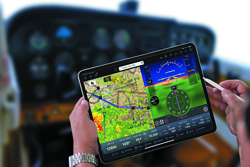
Enjoying huge success with the Stratus portable ADS-B receivers, Appareo joins the crowded app market with Insight EFB for Apple iOS. While Insight provides a lot of the flight management functionality pilots expect from a modern EFB, it adds some unique features, including real-time radio encryption. 

I spent some time with Insight working through its feature set and prepared this field report.

QUICK TOUR

Like all EFB applications, Insight’s center feature is its map. A multitude of layer options allow for a base view showing VFR sectional charts, IFR high or low enroute charts, terrain, street maps and a satellite view. Overlays enhance the base maps with ADS-B traffic, various weather products including weather radar, ground obstruction and terrain warnings, a vector aviation map and fuel prices.

Other than the VFR, IFR and aviation vector base charts, all the other charting requires an active Wi-Fi connection. Insight’s approach to managing map overlays consists of a lengthy list of all the options, and a shorter list you have marked as favorites. Overlays are selectable from either list, although selecting a proper set of favorites can eliminate the need to scroll to find them.

Some overlays have features that may be useful to change while underway, without having to dive deep into a buried settings menu. Whenever any of those overlays are active, a large, familiar-looking gear-shaped settings icon appears at the top of the map. Pressing the gear exposes a settings window that grows and shrinks, depending on the selected overlays, and allows for selecting options like map objects, weather observation values and fuel types. 

A playback control animates the last 30 minutes of radar data, while you can also play back the previous three hours of METAR data on that layer, making it easy to watch trending conditions—either in a good direction or bad—as a flight progresses.

Maps are the first item on Insight’s main menu at the bottom of the screen. To the immediate right of the Map icon is one that launches a full-page view of Transcriptions— Appareo’s real-time audio-to-text transcribing function. See the sidebar on page 22 for a summary.

Insight also includes synthetic vision. Activating the feature splits the map page on an iPad or takes over the entire screen on an iPhone. Full screen on the iPad is a choice, too. Using the terrain database, the airport database, GPS data and AHRS data, the screen presents a typical MFD view with attitude information at the top and HSI data at the bottom. Airspeed and altitude tapes round out the display. Upcoming terrain should render below the horizon line and airport runways should appear substantially as they do outside the cockpit windows. Appareo said that a significant rework of the syn vis function is underway for an expected release in early 2021.

Next on the menu is Airports. Entering an identifier, with or without the leading “K,” brings up a page on an iPad with a summary of field details and frequencies at the top, and the most current METAR observation in the bottom two-thirds of the screen. A slider scrolls through the previous three hours of weather observations and scrolling down shows observations for nearby fields. Other weather products available on the page include TAF, a text TAF discussion, the Global Forecast System (GFS) Model Output Statistics (MOS) forecast, the North American Model (NAM) MOS forecast and a local graphical forecast similar to the basic weather display available on most phones and tablets. The lack of an internet connection does limit inflight weather to the products available from the ADS-B FIS-B data stream. The Airport pages are necessarily more compressed on an iPhone screen. Insight implements the concept of favorites across many of its features, and airports are no different. A heart icon consistently indicates the favorite option and selecting it on the airport page adds the field to a favorites list accessible at the very top of the page. Buttons at the top of the Airports page bring up the nearest airports, the list of fields marked as favorites and a browsing list organized first by state, and then by city name. Other tabs on the Airport page access frequencies, runways, procedures, NOTAMs, and FBO info for the selected field.

The Notepad button on the main menu opens a page that is just that: a notepad for scrawling anything requiring a record. Notes are graphical only and a finger, a tablet stylus pen or the Apple Pencil—on the models that support it—create whatever shapes or letters make sense. Notes collapse and remain on the page until you explicitly remove them.

PROCEDURES, CHECKLISTS

Insight organizes all the FAA U.S. Terminal Procedures via the Procedures tab on each airport’s page. However, a dedicated Plates page button on the main menu serves up quick access to selected procedures. Much like airports, procedures have the heart-shaped favorite icon. Plates you select as favorites will appear in a list on the Plates page. Other lists on the page hold selected plates for the current flight and show recently used plates.

Georeferencing (the ability to see the flight progress on top of the procedure plate) is a standard. Choosing a plate overlays it on top of the current map, in the proper location and orientation, with the aircraft icon positioned where it is relative to the procedure. 

Automating checklists is a common feature on most EFB apps. Insight includes a text-to-speech capability where it reads the checklist item to you, assuming you have a means of routing your device’s audio to your headset. A large check mark button acknowledges the item and moves on to the next.

The default list of available checklists is short (two). A procedure for loading ones you create through the Stratus website seems simple, but during my evaluation in mid-summer it didn’t work as expected. Appareo is looking into it.

A Logbook button brings up a pilot’s log with all the expected fields and features. The front page shows your currency status, a list of recent flight tracks and a graph of flight hours over time. A list of options changes the graph to show total flight hours or hours within a category like instrument or multi-engine time. A graphic map on the page shows all your logged flight routes or just the visited airports. You can exchange log data with other logging programs, but I did not test those features.

RADIO TRANSCRIPTION AND PLAYBACK

That’s the Transcriptions page screen grab

Insight’s voice feature extends well beyond reading checklists. While on the ground it announces an approach to a runway. While in flight the software will warn of obstacles, altitude deviations, nearby ADS-B traffic, terrain and depressurization—if your craft is so equipped. A configurable pre-landing brief reads out destination airport details like elevation, runways, frequencies and other details a set number of minutes before arrival. Descent and climb altitude callouts are another voice option. Appareo’s artificial intelligence division created a nifty speech recognition utility that’s still a work in progress.

An ADS-B FIS-B overlay

Paired with Appareo’s audio cable (plug the headset phone plug into the $49.95 adapter, and the adapter into the iPad/iPhone), the ATC Radio Transcription feature works like visual voicemail. ATC comm is converted to text and is displayed above the audio playback line on the Transcription page. It’s not perfect given the challenges of noisy signals, but we think it’s a good start. Appareo used what it calls natural language processing to interpret the radio transmissions in a familiar way.

For example, when ATC called our tail number “November three one three three quebec,” it correctly transcribed it as N3133Q. Same with “Cleared to land runway two zero,” transcribed as Runway 20. On a busy, shotgun-like frequency it chopped some calls, but for the most part it worked, especially with ATIS.  

Got an Apple Watch? Insight offers a companion application. Six pages of data on the watch track the current flight and provide quick access to a list of the closest airports.

FLIGHT PLANNING

I think creating a flight in Insight will be intuitive for much of the pilot population. Press the flight plan button at the top of the map page, search for or point to the departure airport, search for or point to the destination airport, add any waypoints along the way and the plan is ready to fly. Calculating the details of a flight plan is not possible without aircraft performance data. Adding an aircraft definition to Insight is relatively simple. It starts with entry of the tail number and the ICAO type designator. ICAO does offer a web lookup for type designators that Insight links to, but the site is a bit confusing to use on a mobile device. It is best to know before adding the aircraft that your Piper Archer is a P28A. 

Insight finds the rest of the performance data by using the type designator to search some other database in the sky. A button lights up showing how many profiles in that database match the type. Simply choose the most appropriate one from the list behind that button and save the aircraft profile. With a route and an aircraft profile, Insight calculates all of the flight details. Buttons on the flight plan panel allow for adding other details necessary for filing a flight plan with the FAA, allow for downloading all the data and charts necessary for the trip and allow for briefing and final filing.

Speaking of briefing, if the device has a network connection Insight connects to Leidos without any additional logon requirements and retrieves the standard briefing text. An email containing the full briefing is also sent to the email address associated with your Stratus account, making it easy to reference it before and during the flight. Another planning feature allows selecting the procedures you expect to need for the flight. Those then appear in a “bundle” on the Plates page. While in flight, it should be faster to select a plate out of the bundle than it is to navigate through the full list of procedures for an airport.

Several other details automatically insert into the flight plan when called for. A route longer than the range of the airplane will add a reminder to make a fuel stop. For IFR flights, the planner also applies the 1-2-3 rule to the destination airport weather and, if required, adds a reminder to select an alternate if you have not already done so. A selection tool helps make a choice that meets the alternate criteria and is within remaining fuel and reserves range.

FLYING WITH IT

To check out Insight in the cockpit, I planned a short cross-country flight with an intermediate waypoint on the way out. A few minutes into the flight, the base sectional map became blurry and did not appear to be updating as we progressed along the magenta line. A bit of troubleshooting found that I had failed to select the offline VFR base map prior to takeoff. Changing the setting cleared the issue. Appareo indicated that the next release will remove the requirement to manually select an offline option. Insight will automatically select the most appropriate map for the situation.

A final approach for the local commercial airport crosses a downwind departure from my home airport’s Runway 16. It was not long before Insight’s voice began calling out traffic that was laterally close, but thousands of feet above us. There do not appear to be any settings to adjust that specific sensitivity. A bar holding a wide variety of instrument values like groundspeed, ETD and GPS track pops up from the bottom of the map page. One of the instruments is barometric altitude and this was the first opportunity I had to fly with an iPad that included a baro sensor. After entering the current altimeter setting, the instrument was remarkable close to the aircraft’s altimeter, varying only by a foot or two. The default configuration has all the instruments enabled. Access to more than the six that fit on a 10-inch iPad screen is by scrolling the entire bar left and right. Settings do allow for shortening the bar by disabling ones you are not interested in.

A flight recorder keeps a log of the actual track over the ground and other flight details. It starts and stops automatically based on GPS speed and will transfer most of the flight details to Insight’s logbook if, of course, you are using it. 

Insight’s altitude departure voice alerts operated as expected. The software detects level flight and reports a deviation of about 100 feet above or below the level altitude. The feature’s sensitivity seemed to be about right and did not create excessive alerts. The pre-landing brief played at the appointed time before reaching the destination field. The default briefing is quite lengthy but is editable in the settings. Going forward I will opt for a more concise script. I was disappointed that destination weather observations cannot be part of the briefing.

The synthetic vision feature worked as expected, although some of the tags and labels appearing on the horizon used a ridiculously small, unreadable font. Other than that, I live in an area with only minor variations in terrain level, so it was difficult to give it much of a test. As I noted before, a major rework of the feature is underway.

Selecting a waypoint off the flight plan panel and selecting the Info button opens a summary window for the airport. Sometimes, but not all the time, the panel appeared behind the flight plan bar, requiring a collapse of the flight plan bar to see all the airport details and access other data like procedures and the weather.

GOOD VALUE

At $9.99 per month, that’s a good way to describe the app. It implements an extensive feature set, with reasonable access to elements without drilling down through layers of menus. And, at least right now, Insight is the only option with real-time audio transcription. According to Appareo’s Kris Garberg, a vision for the software is to continuously improve its automated analysis features and to make the voice aspects a core part of the experience. Voice alerts and transcription are a focus, and we should expect more features like them in the future. Visit www.appareo.com.


Freelancer Randy Dufault splits his flying time between a Cirrus and a Cherokee in Minnesota.