by Jonathan Spencer
Cell phones are rapidly becoming the universal communications device-you can use your phone to make calls, take and send photographs, access the Web and send text messages. So why not use it to get aviation weather? A number of sources offer just this service for enabled phones.
But are they all practical? We tried several weather-by-phone services to see how we’ll they deliver aviation weather. We did some of the testing during Hurricane/Tropical Storm/Tropical Depression Charleys passage up the east coast, so we had numerous opportunities to test NEXRAD capabilities of the services. We also did much of our testing near a desktop computer with a broadband connection and that served as our basis of comparison.
Limited View
The biggest limitation of this cell weather concept is the phone itself, some of which don’t provide Web access at all. If you have one of these, you’ll have to decide if getting aviation weather on your phone is worth the cost and hassle to upgrade your phone. Among those phones that do provide Web access, there’s some variation in capabilities, especially when it comes to screen resolution.
We use a Nokia 3595 that provides Web access but has a low-resolution screen (96 by 65 pixels, 4096 colors). Text METARs and TAFs were readable but required a lot of scrolling to view longer reports. The NEXRAD information on a phone like this is primitive at best. You can only see a portion of the image and considerable scrolling is required to see the complete image.
Another annoyance: the 3595 doesnt have horizontal scroll buttons and the NEXRAD image we did get we judged to be not very useful. It was obvious when there were no echoes, of course and it was equally obvious when we had enough convective weather that flying was simply not an option. But we wouldnt use this image to devise a weather avoidance strategy. To make matters worse, those areas that should have been blue (light rain echoes) were black on the 3595, making the image that much more difficult to interpret.
Available Services
Given the inherent limitations of the phone screen, the only three areas the various cell phone aviation weather services can compete in are what weather products they provide, what mechanism they use to deliver it (Web, messaging, or e-mail) and price. Heres a rundown on the different services available:Accuweather-Although not specifically for aviation, it does include animated NEXRAD for some phones and services. Includes the usual variety of (non-aviation) weather information but supplemental aviation data. (www.accuweather.com/iwxpage/adc/mobile/index.htm)
EMETAR-eMETAR provides two services. The first is a METAR-on demand e-mail service. Give them an airport identifier and an e-mail address and theyll send you the current METAR for that airport. The second is a weather watch-and-notify service. Give them an airport identifier and a set of weather conditions and when the weather at that airport exceeds those conditions, theyll send an e-mail to your phone. They also provide a weather alarm service to provide METAR for a specific airport at the same time every day.Requires registration for some of the services, but its free. (www.emetar.com)
Hz.com-The website is, well, weird. Nonetheless, if you work your way through the rather odd Flash menus or use the alternative HTML menus, which we recommend, you’ll find a free e-mail service that, among other things, e-mails you METARs and TAFs on request. What other things? The address corresponding to a phone number, an area code/city match-up, the joke of the day, stock quotes and non-aviation weather by city. Registration is required but its free. (www.hz.com)
METARTAF Aviation Weather- Want to get your local airport weather every morning on your phone at the same time every day? This is the service for you. You can specify the airport, when you want a METAR/TAF and for how many days, weeks or months. You can get every report issued, one report a day, or almost anything in between. Registration is required but its free. (www.metartaf.com)
Pilot My-Cast-My-Cast is a weather service that claims to be generating better forecasts than NWS. They say theyre updating their forecasts twice as often and use a finer grid. Most of the forecasts are delivered via the Web to desktop computers, but theyre now offering some mobile services, including Pilot My-Cast.
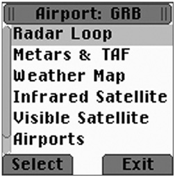
They provide NEXRAD loops, satellite images, METARs, TAFs, and weather maps. The weather maps are a multi-image derivation of the METAR maps you can get from the Aviation Digital Data Service (ADDS) site, showing, sequentially, flight conditions, wind barbs, weather, cloud cover, temperatures, dew points, ceiling, altimeter, visibility, and observation time. You can also pan back and forth beyond the area youve selected and you can zoom in and out. One neat feature is the option to specify a route by a series of airports. You can then go through the airports on that route looking at the weather along the route.
While My-Cast is missing some useful aviation information like PIREPs, it was an easy application to navigate and use. It requires downloading an application to your phone and you need a high-end phone. Cost is $9.95 set-up plus $9.95/month or $99.95/year. (https://secure.my-cast.com/pilot.jsp)
Smsavantaj- The name of the service isn’t the only thing thats odd about it. They provide a Web-based service that claims to provide METAR, TAF, weather charts and airport information for airports worldwide.Unfortunately, their website is written in broken English, their billing system doesnt accept MasterCard and the billing page notes that they are in Turkey, which raises questions about customer support. Their geography is a bit rusty also-they list KBED, our home field near Boston, as being in Connecticut. The price is low, however: $2.95/month. (www.Smsavantaj.com)
Sportys Flight Planner- This service uses data from the DUATS server, so the weather you get qualifies as an FAA weather briefing. Because of this, you have to have a DUATS username and password to use it. This is the only system we reviewed that provides FAA weather briefings.
Because it uses DUATS, you get access to data that the other services cant provide, such as PIREPs and TFRs. Unfortunately, this is raw TFR data in the usual all-caps text, which, we suspect could be even more difficult to read on a phone screen than it is on a full-sized computer screen.
The DUATS connection means this is the only system that allows you to file and close flight plans. One interesting feature is the option to remind you to close your flight plan a half-hour after your planned arrival time on a VFR flight.
Unfortunately, this service doesnt work with many of the popular cell phones. If you have a phone that uses the BREW runtime environment (these phones are currently offered by U.S. Cellular, Alltel, and Midwest Wireless and a couple of other small carriers) you can use this feature. Everyone else uses phones with J2ME and cant use it.
There’s a detailed Flash demonstration of the entire system on the Website. While the flight planning is a nice feature, the limitations of a phone keypad make entering the details of a flight plan tedious even to watch in a demo. A big shortcoming is that Sportys doesnt provide, and doesnt plan to provide, any weather images including NEXRAD. As of this writing, Sportys Flight Planner is not available on Verizon systems but should be by the time you read this.
The Sportys Flight Planner requires downloading an application and only works with high-end phones like the Motorola V400. $5.99/month. (www.sportys.com/flightplanner)
Wx2me-Strictly a text messaging service. You send them a text message with the format M KBOS for a METAR report, T KBOS for a TAF report. In a few minutes you receive the information back as a text message. $5/month or $55/year, but note that there are free services that do pretty much the same thing. (www.wx2me.com)
WxServer-WxServer is trying to be the 800-pound gorilla in this business. They have a smooth operation and are adding services rapidly. Their Website is a little disjointed, but if you go to the site map page, you can find almost anything. One measure of their confidence: One page of their Website is devoted to the competition, including links to their competitors sites.In addition to the usual weather information, they provide lookups for ASOS and ATIS numbers as we’ll as the FSS local numbers and (for most phones) the numbers are links allowing one-click dialing.
Recent additions include airport information such as car-rental and taxi phone numbers, also with quick-dial links and an airport search database that allows you to enter the name of a town or city to get a list of the associated airports.
Unlike some other services, WxServer is totally Web-based and doesnt require downloading an application. The downside is that its more affected by Internet slowdowns since everything must be downloaded rather than retrieved from a local application. While the service works with any phone that has Web access, the NEXRAD images arent very useful on phones with low-resolution screens. $6.95/month or $59.95/year. (www.avwx.net)
Conclusion
Its clear that these are supplemental services, at best. Between the limited screen size and the limitations of a cell phone keypad, phone-based weather can hardly be called the most convenient way to obtain weather. And because of limitations on use of a cell phone in the air -both legal and practical-its also not a source of in-flight weather information.