by Larry Anglisano
The MX20 MFD, introduced in 1999 by the then UPSAT for use in Alaska-bound UPS cargo jets, started a major integration trend that other manufacturers, mainly Avidyne, would attempt to outdo. Advanced for its time, the early MX20 won an Aviation Consumer product of the year award and proved a hit with buyers, who raved about its display and versatile operating logic.
In MX20, UPSAT and later Garmin came close to perfecting the true purpose of an MFD in overlaying traffic, terrain, multiple aeronautical maps, Stormscope, plus ships radar and datalink weather. But seven years is a long time in the world of avionics development and with competition from Bendix/King and Avidyne, the MX20 has been looking dated.
So now comes the MX20s replacement, the Garmin GMX200, which is offered in several versions. The $8995 GMX200 standard MFD, the $10,995 GMX200 I/O Traffic, which plays a variety of traffic products and the $14,995 GMX200 I/O Radar/Traffic, overlaying ships radar, traffic and TAWS-B terrain.
Although the MX20 appeared under the L-3 nameplate as the i-Link system, L-3 says it has no plans for doing the same with the GMX200, which now appears to be a Garmin-exclusive product.
Speed, interface versatility and bright color are the hallmarks of modern MFDs; buyers want it all and they want it now. Clearly, the MX20 needed a boost that yet another software upgrade just couldnt provide. In the installation shop, techs wanted a more mature MX20, having tired of dealing with roundabout interface protocol during installations. While it was a great match when married to the Garmin line, the MX20 didnt always play nice with others.
Based on specifications alone, the GMX200 promises to address these shortcomings. The original MX20 wasnt quite up to Garmin standards in terms of rugged installation hardware, but the MX200 is, with cooling and serviceability fine-tuned based on installer feedback.
Mods RequiredWhile the physical size of the mounting rack remains similar, the rack design is different, so existing MX20 interfaces will need mods to work correctly. When making the switch from the MX20 to the GMX200, shops will need to make minor changes to the wiring once the rack and backplate are changed.
A required configuration module stores interface parameters pertinent to the remote sensors that might be in the airplane. While this consumes shop time, it reduces grief if a given GMX200 is ever replaced with a different serial number. To us, the extra cost is worth it.
Another cost-escalating hassle with MX20 installations is gone in the GMX200: the pressure altitude input. For terrain warning functionality, the MX20 needs an altitude input from a high-resolution serial converter and digitizer, an expensive addition. The GMX200 makes it easier, automatically accepting GPS-derived altitude when communicating with GPS navigators, a welcome feature for installers. To be sure, if a GNS430 is interfaced with a GMX200, its input alone is sufficient to provide altitude input, eliminating extra wiring and additional hardware. This could save $500 during installation.
Another other improvement is the addition of more data interface potential. The GMX200 now has potential for five RS232 ports compared to three on the MX20. On the GMX200 I/O Traffic and Radar versions, there are also ARINC input ports for sending radar and TAS/TIS traffic data in. While more RS232 ports might simplify wiring and allow more interfacing, we still wish that all avionics interfaced with an ARINC digital data bus. It just simplifies things.
Dedicated RS232 ports get eaten quickly if you load up the interface. For example, count the must-have GPS input thusly: One, a WX-500 Stormscope; two, a GDL69 XM Radio interface; three and four, traffic input and five, ADS-B.
The GMX200 handles nav data input a bit differently. Built into the units side chassis is a slot that houses the main operating software stored on a compact flash. The navigation data, including Jeppesen Chartview, is loaded on what Garmin calls a SecureDigital card thats inserted through a slot on the units front lower bezel.
We think this is a great improvement over the MX20, where operating software could easily become corrupt, leading to the aviation version of the Blue Screen of Death. Also, the operating software is hidden in the side of the chassis, eliminating the bone-head mistake of yanking the card from the reader while the unit is powered up in flight.
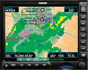
One complaint about the MX20 is display size. The MX200 addresses that with a 6.5-inch (diagonal) display measuring 5.2 inches wide by 3.9 inches high. The MX20 measures 6 inches on the diagonal. The GMX200 is brighter, too, with an enhanced viewing angle catering to larger cockpits. The high-resolution AMLCD display with a 640 by 480 pixel count has improved backlighting for an even brighter glow. But the huge screen comes at a space and weight premium. The GMX200 standard weighs roughly five pounds and measures 5 inches high by 6.27 inches wide by 9.82 inches deep. This is a big unit and it will quickly chow down a lot of panel real estate.
Blazing SpeedBut the real news is the speed of the GMX200 processor, which runs at a lightning fast 650 MHz compared to 266 MHz for the MX20. This makes for speedy map redraws, quicker scaling and quick loading of approach charts.
On the topic of scaling, the MX20 has limited scaling extending out 250 nautical miles. But that limitation is gone with the GMX200, which scales from 1/4 mile all the way to 2500 miles, controlled via rotary knob rather than rocker key. The quicker speed and increased memory (256MB compared to 32MB in the MX20) supports a feature that everyone wants and thats animated NEXRAD weather graphics.
If the GMX200 has a weakness, that would be its somewhat limited radar model overlay capability. There are many older radar models still in service and many owners are sinking big dollars into repairing them, hoping to upgrade to a newer display. The question? Will the GMX200 play my old radar? In many cases, the answer is no. And were not sure this is going to change, even as the MX200 matures.
Older singles and light twins often have Bendix RDR-series black-and-white or earlier vintage ships radar and if the GMX200 could play these, it would seal many a deal. Garmin needed a dedicated display for their recently introduced retrofit ships radar and the GMX200 I/O Radar version (less radar, of course) does just that. It plays the 6000-watt Garmin GWX68 ships radar returns in four colors and controls range and tilt through a dedicated radar command page. There’s stiff competition for Garmin to contend with in this department, mainly the Avidyne EX500 and Honeywell KMD850 displays that also overlay onboard radar. But the GMX200 I/O Radar has one up on the competition already, playing the GWX68 radar. The EX500 and KMD540 overlay radar, but not the GWX68, which, at this point, is showing signs of jump-starting a fading market. The GMX200 I/O Radar version plays the competitions radars, including the Honeywell RDR2000/2100 and RS181. Omitted is the Bendix RDR series and KWX56, of which there are many still in field. These will be sales lost to Avidyne, in our estimation.
The EX500 still wins the radar overlay contest, being capable of showing radar returns from an impressive variety of radars. Just when we thought onboard radar was gone, owners of light twins and big singles are showing more interest than ever in playing sferics, satellite weather and ships weather radar.
Datalink WeatherFor those who can or must do without onboard radar, the GMX200 has been refined to present impressive datalink weather in animated motion. Thanks to the memory upgrade, putting the weather in motion is possible, as is the ability to fetch maps and other data without having to wait for a slow processor to catch up with your commands.
The new rotary knob in the lower right corner of the bezel plays an important part in examining the weather and moving the map. Crank it around and you could see 2500 nautical miles of NEXRAD-the weather picture for virtually the entire country. The ability to overlay the weather graphic on useful maps rather than just a base map, as with the MX20, is a huge improvement.
Unlike the limited weather abilities of the Avidyne EX500, the GMX200 covers most of the weather product bases that users want, including animated NEXRAD, METARs, TAFs, TFRs, winds aloft, echo tops, AIRMETS, SIGMETS, surface precip, lightning strikes and storm cell data.
An XM Radio entertainment tuning page remains in the GMX200, a carry-over from the MX20. Other brands tune the tunes with a Bluetooth remote for passing around the cabin, which we think is slicker but takes control away from the crew. For modern old-fashioned lightning detection, the GMX200 will accept the RS232 stream of a WX-500 Stormscope.
Traffic, Charts, TerrainSplit-screen charting with vertical profile terrain monitoring was perhaps the best feature of the MX20 and it remains so in the GMX200. Color-coded advisory terrain and obstruction data fetched from the terrain database is enough to keep you out of trouble, while the ability to play TAWS-B, through the L-3 Landmark TAWS-B sensors, will keep even the largest of jets TAWS-B compliant.
Flying along an electronic airway chart, especially if the flight plan is loaded into a GNS480, is a nifty example of the GMX200s charting abilities. It also has Chartview, Jeppesens approach procedures, with geo-referenced flight plan and aircraft movement overlaid.
Automatic surface chart depiction on departure and arrival is a feature owners seem to like. We wish the GMX200 had a remote device on the lines of the Garmin Ready Pad, which is used to control the G1000 glass in some models of Columbia airplanes. If it did, we think the automation would be brought to a higher level, making chart loading easier while flying with a handful of airplane on an approach. Remote devices for programming the box have been common in big airplanes for a while and were surprised to see side-stick programming absent for smaller ones.
With the GMX200 I/O Traffic version, traffic can be interfaced from the GTX series of Mode-S TIS transponders, as can active TAS systems including Skywatch and Skywatch HP, Honeywell TAS, the Ryan TCAD data stream (now Avidyne TAS600 series) and some TCAS I processors. TIS-B, from the GDL90 ADS-B processor, is also an option.
Raw Nav data from Garmin-AT SL30 or GNS480 can be inputted to the GMX200, as in the previous MX20 interface, highlighting the raw nav source in magenta on the map.
ConclusionThe GMX200 addresses most of the MX20s shortcomings and then some. After years of working with the configuration process of these systems, we have to say it couldnt get more straightforward. Most of the guesswork has been taken out of initial configuration and setup. The software was designed with the installer in mind and it works well.
And thats the overall theme of GMX200, retaining what works and improving the features that owners and technicians said they wanted. While we wish that the GMX200 I/O Radar offered more interface potential, we suspect Garmin will get to that. Meanwhile, the screen clarity, processor speed and interface richness of the GMX200 easily make it worth the asking price. We expect to see stiff competition between the GMX200 I/O Radar and the Avidyne EX500 radar MFD and that can only be a plus for buyers. Of course, complicating any MFD purchase now is Garmins introduction of the G600 PFD/MFD, as shown at right. It may turn out to be a game changer.
-Larry Anglisano is Aviation Consumers avionics guru. He works at Exxel Avionics in Hartford, Connecticut.