For-Pay Flight Planners: It Depends on Your Style

Voyager 4 leads if you mind meld with its novel presentation. For more traditional thinkers, FlightPreps Golden Eagle Plus gets the nod.

With so many free resources on the web, any fee-based solution must offer serious added value. And thats exactly the rub with a critical review of the different options: One pilots added value is another pilots useless frill.

All of these products do everything you need, but one might fit your style better than the others. To help you find your match, we looked closely where flight planning can really shine:

288

optimizing a route for winds and fuel stops, accessing the most current airport information and printing a wad of information to toss into your flight bag.
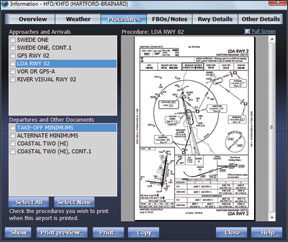
Golden Eagle Plus

Flight Prep Golden Eagle Plus wins our prize for all hitting all the important items without any frills. Its also relatively intuitive to use. Golden Eagle Plus is an enhanced version of the free Golden Eagle software. The upgrade adds scanned charts, approach plates and airport information from NavInfo.com and Flight Guide, by subscription of course.

The window layout is utilitarian, as is much of the data presentation. For example, METARs are displayed on the map with color coding for a quick view of whats going on but the pop-up details are on a single line of text. While were on the topic, automation of weather was a weak point for Golden Eagle Plus. TAFs cant be shown on the map. NEXRAD can be displayed, but its not downloaded automatically. You must get the data by connecting with DUATS. Theres no display of weather over time as with Enflight, Flightsoft or Voyager.

But manual control isnt all bad. Select the Compare Altitudes function and youll see a simple table with altitudes and total times for your route. Pick the one you like best and the nav log, chart and profile view update. There are also hidden powers that take some manual reading, but work well. The “plain language router” is probably misnamed; a command “KHIO NOONS *V-7000 KRBL” isnt exactly vernacular, but it will plan a flight from Hills-boro to Red Bluff via the NOONS intersection then airways but no higher than 7000 feet. The same can be accomplished more intuitively by other software, but not so quickly.

The approach plate viewer for Golden Eagle Plus is simple but effective. Departure procedures appear with approaches, something thats overlooked on many planners. Golden Eagle Plus can export the nav log, plates and charts (scanned or its own maps) to a PDF trip kit. This ets you take as a file or print

288

whatever information you might want. You cant, however, export the FlightGuide data to the trip kit, although you can print it separately.

Golden Eagle Plus wasnt as safety conscious as some other packages. It let us choose an altitude that took us right through a mountain without warning. In fairness, the path through the mountain was available on the profile view.

The online version of Flight Preps planner is similar to Golden Eagle plus but not identical. Most noticeable is the ability to split screen and show a scanned chart beside the standard map-a surprisingly handy feature.

The tripkit function also lets you add weather charts to the kit, which is not an option in the desktop version. The route wizard lets you view current weather charts before you start your planning. On the down side, the online version only lets you build routes-theres no easy way to just look up one airport within the planner. Ironically, you can easily do it from the FlightPrep home page, which is just a click away.

Jeppesen FliteStar

Jeppesens NavSuite is a combination of their FliteStar flight planner and the JeppView software for viewing Jeppesen plates. If you want integrated Jepp approach plates and Jepp-style en route charts, then NavSuite is the only game in town.

Its not a bad game, either. Flite-Star is arguably the least intuitive to operate of the flight planners, but its powerful in what it can display. Strengths are the integration of the Jepp approach plates and getting information off the map. FliteStar handles multiple objects of your click better than anyone else, asking you what you want if its unsure.

Weather is displayed on the map once youve downloaded it via a DUATs session or by connection with an optional Jeppesen weather service (for an additional fee). Alternate planning, optimizing altitudes and building a trip kit with plates and charts is all there.

The main drawback to FliteStar is the price. The subscription for IFR navigation data is $139-$429 depending on frequency, but adding approach plates is a whole nuther program and subscription. One thing that makes the combo worthwile to some: Jeppesen can be worldwide with charts and plates.

RMS Flightsoft

Flightsoft has been around for quite a while and doesnt look as flashy as some other packages. It is old school in design-you even get a real, printed manual-but, in our opinion, it lacks some of the power of other packages.

The main map is quick to configure and shows downloaded weather as color-coded icons. Click a station to see the details, or use the time slider at the bottom of the window to see conditions in the future based on the TAFs. If you have a flight planned, youll see an airplane icon showing your probable position along the route at that time.

288

Flightsoft is strong in its simplicity. Choose the Winds/Efficiency tool to select an altitude and pick “Best Time” or “Best Fuel.” Simple. Right-click an airport on the map or in the navlog and you get all the critical info in a tabbed popup window. The result is less jumping between windows than Golden Eagle or FliteStar. There are a couple special features like road maps or putting the program on a flash key to take with you that might be just the thing for some.

In other areas, we think Flightsoft is less integrated. Scanned charts open in a separate window, which can be cumbersome. You can print charts, approaches and airport data, but not in a single step.

Voyager 4

The free version of Seattle Avionics Voyager 4 was one of our top picks in free flight planners because it offered so much capability for no cost. The full version of Voyager arguably offers more capability than any of the competition. Its also the most non-traditional in design-and thats why we could alternately put it at the top or the bottom of our ranking.

First the tops: We think Voyager 4 offers more flight planning capability and a better system for viewing weather than any other program out there. The flight planner lets you put in the route directly, put in key restrictions and let Voyager do the rest or just get guided step-by-step through the process. Were not usually a fan of software “wizards,” but Voyager does it surprisingly well, and-more importantly-lets you customize to only show the steps you want.

Great features of the planner include links to all an airports information during the flight planning process and an alternates selector that shows a list of alternates with icons for the weather at the time of your proposed arrival. Routing can be by best time or efficiency, take fuel prices into account and will warn of potential hazards. Almost any parameter is customizable. Its the smartest smart router out there.

Weather is displayed with color coding on each reporting point. NEXRAD, cloudtops and winds are automatically downloaded and can be shown on the map. Clever bits here include showing the wind speed with an actual number rather than the old-school weather barbs, or showing the altitude limits of TFRs.

The signature feature (partially copied by Flitesoft) is a pair of sliders for time and altitude to see how weather and winds change over time, as well as where your aircraft would be at that moment. Click an airport and all the data for it-weather, approaches, AOPA info, whatever-is accessed from one window.

There are more slick tricks, such as toggling a scanned chart

288

on and off at any time and integrated Airnav and Flightguide info. You can print specific pieces of information or procedures, or get a trip book (on paper or PDF) with all the information you could ever need.

But all this capability comes at a cost aside from dollars. Voyager 4 will take out a lesser computer at the knees. (The company still supports the older version of Voyager but it isnt as full-featured.) We also had some issues with Voyager under Vista. They were worked out, but it was the most persnickety of all the software packages we tried.

We did have a few complaints, such as finding it difficult to get the information we wanted with overlapping map information, such as an airport under the airspace of a larger airport or figuring out how to get the airports we wanted on the SmartPlate view. But these we could usually puzzle out. The takeaway is that if you dont want to spend some time learning the program and customizing it to your needs, this probably isnt the package for you.

Enflight

The web-based Enflight is the new kid on the block among these packages and is still growing and adding features. But some of what it offers now is unique enough to get it in this roundup. In terms of basic flight planning, the critical items are there. You can create aircraft profiles and plan routes via direct, VOR-to-VOR, airways, etc. Enflight lacks advanced features such as taking terrain or winds into account. These are planned for the future.

What Enflight does well today is display data. In its flight planning view, it shows your route over simple airways or sectionals. This can appear split screen with your nav log. TFRs, automatically-updating NEXRAD, airspace and other features can be overlaid on this chart. Some of the map items show details on roll over, but not all.

METARs and TAFs are displayed on the chart in a unique, color-coded spiral. The spiral corresponds to time. Click the spiral at some point and youll get the weather for that time. The color coding comes from users settings where you can set minimum ceilings or maximum winds. At a glance you can see where weather is now an issue or will be in the future. Pretty neat.

You get the same color coding on your weather briefing, which makes wading through the text briefing much easier. NOTAMs are also color coded by a different scheme in terms of their likely impact on your flight. Enflight has the ability to print sectionals, charts and airport information, but its not entirely integrated as with other planning software. We do like that it not only shows the charts, but also departure and alternate information if it applies. This is often overlooked in IFR flight planning.

Enflight also offers a mobile flight planner, but for the price, its not quite on par with programs like ForeFlight, WingX or PilotMyCast.

More Online Options

We cant talk about online options without hitting on AOPAs Internet Flight Planner and Aeroplanner, free to AOPA and EAA members respectively. Both offer good access to airport information. AOPAs program is easy to use for flight planning-the best of any online system for editing a route on the map-and has some good weather overlays. Aeroplanner has many charts available and many options for printing it.

Neither site has the strong weather integration to make them contenders. But if youre already paying for the membership, they are effectively free and worth checking out.

More to Come

One complicating factor in this review is that all four PC-based flight planners can be used in flight as well. If youre taking the flight planner with you, a whole new set of factors come in and those impact the utility and ranking of each product.

Were out of space and time here to dive into that abyss. Look for a continuation of this review in an upcoming issue. Until then, take advantage of trial versions of any of the programs that intrigued you to see if one of them jibes with your style of flight planning.