Tablet-Based EFBs: ChartCase Wins by a Nose

What constitutes best really depends on how you plan to use the EFB. Power users will prefer the Voyager Skypad, but we like simplicity in the cockpit.

We get a steady stream of requests for reviews of electronic flight bags (EFBs). In theory, they make sense: all your charts and approach plates in one place and geo-referenced so you can see your exact position, up-to-date airport information at your fingertips and a pre-flight planning tool that becomes the in-flight resource without reentering information.

In practice, were in a Dickensian “best of times, worst of times” state where the technology is marginally up to the task

288

and no one has quite nailed the software. All three of the solutions we tested for this article get the job done-approach charts, sectionals, airport information, XM weather, a moving map GPS-its all there. All have touch-sensitive screens (that work with gloves on). All are available as ready-to-fly solutions and meet the FAAs requirements as Class 1 or 2 EFBs.

Where they differ is in execution, and thats why no one solution is the right one for everybody. In all three cases, theres a flight planning program and weve already reviewed those in our January 2010 issue. The three contenders here come from the same companies-Flight Prep, RMS Flitesoft and Seattle Avionics-but now were focusing only on the in-flight modules. Were also looking specifically at the ready-to-fly packages offered by each company. You could roll your own EFB using any of these programs with your computer.

There are a couple of global things we can say about all three devices we tested. All have excellent battery life, performing fine on a three-hour flight, but youll want to plug them in to ships power for best performance. Direct connections to 12V systems run around $50 and 24V systems are over $100 (using a 24V-to-120V inverter is a cheaper solution). All systems update automatically from the internet. These things all weigh between two and three pounds, which gets heavy in your hand. Yoke and suction mounts can be had for about $60. All three companies have been around for a while with solid user bases and good histories of customer support.

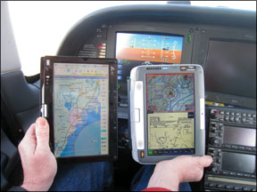
FlightPrep ChartBook

We felt immediately at home with the ChartBook running in its inflight mode. Buttons were big and clearly labeled. The screen is divided into two major sections (upper and lower or right and left depending on portrait or landscape view). One combination might be your flight plan and a sectional chart. The chart would show your aircraft with the option of showing airspeed, altitude and heading as flight tapes or as boxes in the corners. Another combination might be an approach plate and a terrain-awareness page. Either section can be expanded to fill the whole screen with a touch and its only two taps to navigate to a different screens.

The ChartBook plots the aircrafts position on computer-generated moving maps or sectional, low, high or TAC charts of your choosing. These are actual scanned charts that zoom and scroll smoothly. One feature we grew to appreciate was a dedicated “chart” button that flipped us to the chart of our choice no matter what screen we had been viewing a moment

288

before. There is a similar “IP” button to return to the last loaded approach plate. Its another tap to see a list of recently-viewed approach plates. Ease of navigation is a big plus in the cockpit, and these quick switches let us effectively use lesser features, like the checklist page, because critical information was one sure tap away.

Not everything was intuitive or clear, however. We had a lot of trouble getting our brains around the interplay between the nearest, direct and find functions on the ChartBook. Nearest is simple enough and shows current bearing and distance, as well as if an instrument approach is available. Selecting an airport and hitting direct will insert that airport as your next waypoint and navigate you in that direction (perfect for emergencies or diversions). Or you could tap the IP button to see approaches for that airport.

But whichever you choose, getting the other action to then happen (direct or viewing the plate) confounds the new user until you get at the logic of ChartCases find function, which stores recent finds to access them later. You can also see approaches for airports within the range you have set on the map-powerful once you get it because you can pan and zoom to narrow the list quickly, but not intuitive.

Once waypoints are in your flight plan, getting at any information is quick, but editing is one waypoint at a time. There is also no easy way to load the waypoints of an instrument approach into your flight plan, and theres no vertical navigation.

ChartCases simplicity leads to some other limitations. Digging down to get airport frequencies or weather details-particularly for an airport not on your flight plan-is a more tap-intensive affair than other systems.

288

ChartCase has, in our opinion, the best 3D representation with terrain warnings, and it works quite well with the airspeed/altitude/heading tapes. Weather display on the dedicated weather page is extensive, but its limited on the basic navigation pages. They have new options for layering data in views for upcoming releases.

The hardware used for the ChartBook is a CTL 2Go NL1 Tablet PC. The beast was designed for children (which makes it a good choice for the abuse its likely to get in the cockpit). ChartBook comes with either Windows XP or Windows 7. The touchscreen flips around so you can use a built-in keyboard for flight planning or checking your email in the FBO.

The ChartBook package starts at $1795.99, which makes it the most expensive solution. XM weather and Zaon traffic with Bluetooth connectivity can be added for $719.99 and $1589.99, respectively.

FlightPrep offers a terrifically granular system for purchasing updates. Want to buy the latest version of just one sectional chart? Fine, thats $5 please. The full CONUS VFR and IFR charts (and approach plates) package is $357/year. Data for the computer (vector) charts is free. The popular FlightGuide can be integrated into the airport info for ChartBook for an extra $89/year.

Voyager SkyPad

Seattle Avionics Voyager was our top pick for both free and advanced flight planning on the desktop. But the cockpit environment is radically different. Voyagers flexibility and power that is an asset in the comfort of our den, we found to be a hindrance while we were also busy flying the airplane.

288

Running Voyager on the Skypad is more like running a full-featured FMS than a source for charts and a moving map for situational awareness. That means lots of options and power, but a steeper learning and retention curve.

Were convinced that what Skypad does well, it does better than anyone else. Chief among these is access to data. On any of the systems, you can tap an airport on the vector map to get airport information. On the SkyPad, you can tap an airport on the sectional and get a pop-up. All the information is easily accessed through tabs-weather, frequencies, approach plates, whatever-as well as options to go direct or insert it in your flight plan. On a trip from Maryland to Maine where we had the ChartBook and the SkyPad side-by-side performing the same tasks, there was no contest when it came to getting data and weather for an airport and working it into our flight plan. The SkyPad was easier and faster.

Sectional and IFR en route charts are stitched together so that you fly off one chart and onto another without noticing the border. You can layer weather, obstacles, terrain and much more on most of the charts. Rather than having separate windows for sectional or vector charts, you can simply toggle the sectional on and off. In fact, this is the basic design of Voyager: You toggle data on and off as you want and can store presets of views you like as layouts. These can be full screen or split-screen. The split can be even sections or a custom division. You can also navigate by tabs for different views within a screen.

Voyager offers an interesting alternative to datalink weather. You can download weather via the internet before departing and have Voyager paint the weather as forecast for the current time as you fly. That wont help if weather doesnt develop as forecast, however.

The program offers FlightGuide data like ChartCase, but also offers fuel prices from 100LL.com and AOPA airport data (if youre a member). This can make a difference if you have an unexpected fuel stop.

Other features include a scratchpad on its own tab for jotting

288

down a quick clearance (functional, but we still prefer paper for this) and a quick zoom to any scale. If Skypad sees you on the ground at an airport, it automatically shows an airport diagram. Obstacle warnings include bearing and relative altitude-a nice plus. There are also several hidden features. For example, tapping just the right spot on an approach plate pops up a list of all the other plates for that airport. Slick, if you remember where to tap.

We found SkyPad weakly optimized for fat fingers and we reverted to the stylus several times. The text size might also be a problem for older eyes. The ability to tap and get info on a scanned chart (like a sectional) makes panning across that same chart tricky. It takes some practice to get it right.

Getting the most out of several Voyager features takes practice. The direct-to function can be used like any direct to, but it also has power options for specifying a course or going direct to the nearest point on a specific airway. If you use these features regularly, they may make the SkyPad the best choice for you. But we think many users wont ever touch them. Another example of this might be the ability to add not only the final approach fix and glidepath to the runway to your flight plan, but actually add guidance into the downwind, base and final for a specific runway. Its a cute feature, but we think having your position marked on a moving map should be enough to get you in position for the appropriate downwind.

Voyager is processor-intensive and taxes the Tablet to its limit. Startup is slow, in our view, and there can be a noticeable

288

delay rendering some charts-sometimes so long we thought the computer had crashed. We learned to be patient.

The SkyPad lists for $1095. Its an extra $349 to get it with a solid state hard drive. This is essential if you fly over 10,000 feet. If you want XM weather with a SkyPad, its a bit more than the others at $695 for Bluetooth. If you already have an XM receiver, there will be a $199 fee for XM integration on the SkyPad. Data for the EFB (data, charts, approaches,) is $299/year or $829 for a lifetime subscription. You can also get smaller packages, such as just VFR data for $99/year or $297/lifetime. Flight Guide is an extra $49/year.

RMS Vista EFB

As with our review of Flight Planners, the EFB from RMS Flitesoft took the bronze medal, but the gap between it and the leaders wasnt so large this time.

The in-flight program is called Vista and it gets good marks for simplicity. Buttons across the top switch between scanned

288

sectionals, en route charts, selecting an approach plate and the VFR and IFR vector charts. Want an approach? Tap the approach button and you can choose from a list of specific approaches for many nearby airports. We liked the clear course line on the airplane icon, and the fact that terrain and obstacle status appear regardless of what page youre viewing.

Vista works a bit differently for tapping on the map as it matters which tool you have selected. While not a real problem, youll sometimes will tap in vain until you realize you have the wrong tool selected. Vista is also the least optimized for control via fingers. You can still do everything, but some scroll boxes and such were hard for us to manipulate. Some functions require calling the windows menus which takes an exact touch or the stylus.

Vista has a unique trick called the Flight Panel. This window shows a terrain map, profile view and relative bearing to several key waypoints. It proved handy when calling for flight following or watching for terrain on the missed approach. Similar is the one-click emergency window for a simple moving map showing the location of the nearest runway (complete with runway number) and critical data for that airport.

We also liked the simplicity and utility of the nearest function which displays nearest airport, VOR, intersection and NDB first and then lets you tap to see more of any of those items, including bearing and distance. Like Skypad, it automatically shows an airport at startup or after landing. Vista can display multiple maps and screens at once in separate windows, for an equivalent to the split screens on other platforms.

In the negatives column, subtle but important things are lacking in comparison to other units, such as nearest airports being highlighted on the moving map as you explore them in the nearest list (as ChartCase does) or seamless integration of weather or flight plan editing (as Voyager does). You also cant easily view the flight plan directly in Vista. You must switch to Flitesoft, which is not optimized for the touchscreen. You can, however, create a new route in Vista from the moving map or the direct-to button.There were also some oddities such as an obstacle warning we got while dead center on a glidepath GPS approach.

288

The Flitesoft EFB uses the Asus T91 Tablet for its hardware. This unit is lighter than the 2Go, but it was noticeably slower in switching views. The screen also has significant glare in bright sunlight. The EFB is $1200 for Flitesoft Pro (piston, low-altitude) and $1500 for Flitesoft Commercial (turbine, high-altitude). A USB GPS is included. Its an extra $50 for Bluetooth. XM weather is $595 via Bluetooth. Data updates are $238/year and $338/year, respectively.

More to Choose From

Another contender in this showdown should be the AnywhereMap Duo, but the company could not get us one for testing by our deadline. Well try and look at it in an upcoming issue. Well also take a look at the Jeppesen EFB in a future article. The rumored adding of sectional charts to AV8OR Ace makes it a contender, and the advent of the Apple iPad and similar Android-based tablets are sure to shake up this market as well.

Our takeaway from this all is that if your back is already sore from hauling around three cubic feet of approach plates and charts, one of these solutions may be just the ticket for you. However, if your current chart and GPS solutions are functional, however, we think future offerings from these companies and others will be the ones that finally deliver on the EFB promise that has so far proven so elusive.