by Larry Anglisano
Just when we thought the aviation portable GPS arena couldnt get any more crowded, along comes another player vying for a piece of the market. Even though the field only has two players now-Garmin and Lowrance-new models seem to appear several times a year. In a nutshell, Lowrances AirMap 2000C picks up where the AirMap 1000 left off, offering yet more tricks, this time in living color and at a bargain price point. (For a review of the AirMap 1000, see the March 2004 issue of Aviation Consumer.)
Many of the features found in the AirMap 1000 are carried over into the 2000C, so we’ll touch upon major tricks and overall capabilities and performance in this review. In our view, most pilots would be hard pressed to use a fraction of the features found in the 2000C and this is not uncommon with any piece of new avionics, whether portable or panel mounted.
Lots of Standards
As we opened the shipping container, the first thing we noticed in bold, black and white print was a Made in Mexico label on the side of the box. Is it possible that this has something to do with the 2000Cs price point of $999, a bargain for a flagship product like this? Perhaps. The price includes almost everything youd want for most operations, including a RAM yoke mount, remote amplifying GPS antenna, cigar plug power adapter, MMC data card reader/writer, suction mount bracket for automotive use, four AA batteries for back-up power, Map Create mapping software, a protective carry bag and a protective display cover.
We think the carry bag and display cover is the smartest touch to date, as any portable unit we use endures punishing manhandling.
As weve noted in previous Lowrance reviews, the users manual is very good, assuming as it does that every user is a technological idiot. Just the same, we think any pilot can work the unit in its basic form without consulting the manual. For advanced operations under high workload, however, get out your reading glasses and hit the book.
The 2000C is a hardy unit, weighing in at 1.45 pounds and measuring 6-1/4 by 4-7/8 X 2-1/2 inches. The screen size is 5 inches and it shines bright and sharp in 256 colors with a 320 vertical by 240 horizontal pixel count for a total pixel density of 153,600. The specs call the display a 1/4 VGA color, transflective TFT. We call it bright and crisp.
But the price to pay for this sharpness is power consumption; standard AA alkaline batteries wont last longer than a couple of hours and even so, the screen wont shine nearly as brightly under alkaline power as it will on ships power, since the screen dims automatically to conserve power while on batteries. For full-time power, you’ll need to plug the unit into ships power. The standard cigar lighter power adapter provides 6 volts DC. These days, most airplanes have an accessory socket, so consider the AA batteries that load into the rear case for emergency back-up only. If there were an interruption in external power, the AAs will keep the unit running for a couple of hours. An optional rechargeable gel cell is available, if ship power isn’t an option.
Flight Trials
We flew the 2000C in a Cessna 182 and in a Piper and the RAM yoke mount worked we’ll in both, although the unit has a big, in-your-face presence. Its almost too much compared to other newer portable models we tried recently, such as the Garmin GPS296 and GPS96 series. In our view, these are the perfect size for yoke mounting. The challenge with any portable is to find a spot to hang your approach plates when the unit is front and center on the yoke.
To test the unit in road mode, we brought it along on a snowboarding road trip in our Nissan Xterra, but couldnt get the suction cup mount to stick for very long on the windshield. The 2000C seems too heavy for it and it dropped hard on the floor.
We suggest getting creative with one of the many RAM mounts available for automotive use. And if you do use it regularly in the car, the 2000C will accept higher-detail MapCreate data transferred onto optional memory cards for point-of-interest search guidance. This card is inserted into the MMC slot in the back of the unit. Standard aeronautical mapping detail includes an Americas database with airports, VORs, NDBs, intersections and airspace data plus ground obstructions measured in either AGL or MSL heights.
The Jeppesen and Lowrance aeronautical database is stored on a 32MB storage card that lives in the rear of the unit. The navigator has a base map of the world, with low-detail maps of rivers, major lakes and political boundaries. Medium detailed maps of U.S. cities, interstates, state highways, large and medium-sized lakes are also contained as part of the background map.
The amplified remote antenna is durable and often not necessary, as the 2000Cs built-in antenna does a fine job of keeping the WAAS-enabled 12-channel GPS engine locked on. The GPS receiver is so tight, it actually locked on when we powered it up indoors, catching signal from a nearby window. For added confidence, especially in a high-wing airplane, we suggest using the remote antenna.
Input ports forged and molded into the back case for plugging in the remote antenna and power cable are well-designed and seem rugged enough for repeated connects and disconnects. Be careful with the remote antenna cable, however; its spaghetti thin.
Controls
The rubber command buttons are the same as found on the AirMap 1000 and they have a durable, positive feel. And this is the overall tone for the 2000C design, a durable and hefty chassis, if not border-line too-heavy for a portable. The PWR/LIGHT button turns the unit on and off and activates the screen backlighting while the PAGES button steps the unit between the three operating pages: Satellite (signal status), Navigation and Map. More specifics on these pages to follow. MENU calls up the menu for a given page and allows selection of specific functions and options for the page in drop-down format. Rocker pad arrow keys up, down, left and right move through menus, pages and provide function to the on-screen cursor when active. ENT/SAVE executes menu commands.
A weird function that baffled us in previous Lowrance product reviews occurs at system start-up. A couple of messages appear on the screen, mainly a disclaimer about not using the unit for primary guidance and such, and we had a tendency to naturally bang on the ENT key in hope of acknowledging the darned message. But you need to press EXIT, not ENT. We never did get used to this and fell into the trap on every start-up.
ZOUT and ZIN keys are for zooming the map in and out, between .02 and 4000 miles for a total of 39 map display range settings. The keys also initiate a nearest airport search in panic mode. The FIND button performs double duty, initiating the search menus (waypoints and such) and commanding direct-to a waypoint. Overall, we find these buttons reasonably easy to navigate and the 2000C operating software often offers several means of accomplishing the same task, just as the manual promises.
Overlays, Glass Cockpit
While the aviation mode of the 2000C is simplified with just three major pages, don’t let this fool you-the user still has many options for configuring the data on the pages and the overall navigation data, including a glass-cockpit-like presentation. You can tell that there’s airline pilot influence in the design of the more recent Lowrance navigators, as the ability to mix and match different maps and nav data is bountiful.
Its clear that the 2000C can suit many different pilot preferences, from down-and-dirty, get-me-there data presentations to multi-maps, with flight instrument data overlay. In fact, the MAP page has five options in which the user can select map panel-a combination of GPS-derived flight instruments and moving map-full map page, compass overlay, two maps on one page and an aviation map.
You have the choice of many combinations to customize on these map pages, depending on your mission and flying habits. We found that overlaying the compass function over the map provides the best in no-nonsense situational awareness.
Each of the three main pages has a submenu, accessed by pressing the MENU key, which pops up options for customizing the data for each page. Once you get the unit set to your liking, there should be little flip-flopping between pages to hunt for critical nav data. For example, the navigation page has a compass display in one window with a map display in another window, almost like a picture-in-picture presentation.
There are also data fields that can be customized to display lots of common flight data, such as groundspeed, distance, track and altitude. We were amazed at the amount of data we could display on this single page. Having said that, its a good thing that the 2000Cs screen is as sharp as it is or it might otherwise become too busy to interpret.
As proven with the advent of primary flight displays (PFDs), lots of data overlaid on one screen doesnt necessarily make flying the airplane any easier. And speaking of PFDs, the 2000C mimics one with its glass cockpit panel display. While this doesnt show you everything you need to precisely maneuver the airplane in the clouds, it can be a big help in partial-panel control, with the added benefit of highly detailed navigation data.
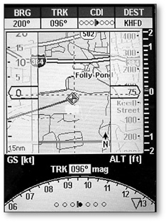
With another set of eyes looking outside, we tracked inbound on a GPS approach-including flying the step-down fixes-using the 2000Cs pseudo glass cockpit panel. On the right of the display, there’s a GPS altitude window with vertical speed data on the far right, on the left is a groundspeed window and in the middle of it all, the 2000C has a colorful, detailed map.
The bottom of the page has a compass overlay for directional magnetic track data-not to be confused with true heading. If youre navigating to a waypoint, there’s CDI guidance in the center of the compass rose. The VSI presentation takes a little getting used to, as you’ll need to interpret small and larger tick marks that represent hundreds and thousands of feet per minute worth of climb or descent. In our view, you shouldnt buy the 2000C thinking youre getting a $900 glass cockpit. But what you will get is a detailed summary of the flight path in the horizontal and vertical along with a sharp mapping picture. Put it all together and the view is darned impressive for a portable unit.
An HSI presentation with a cross track error box, bearing pointer and CDI needle can be displayed between the altitude and groundspeed trend columns instead of the map display. And as with other Lowrance models, the OBS hold function allows for maneuvering the airplane temporarily off of course to avoid weather, fly radar vectors, avoid airspace restrictions and so on.
In keeping with the tradition of other Lowrance portables, the 2000C has an excellent airspace alerting feature that tells you everything you need to know about airspace that you might wander through-or have already wandered into. Pressing MENU, ENT runs the airspace command and up pops an airspace box showing ceiling, floor, distance and time remaining for a given airspace penetration. For shame on users who violate airspace when using the AirMap products.
If the busy glass cockpit presentation confuses you while youre trying to navigate, you can always run on the compass overlay page. Essentially, this page is a map display with a portion of the compass rose displayed in the upper area of the screen. A bearing icon points toward your destination waypoint on the map and a CDI under the airplane icon shows you on or off of your course. Even on this page, you configure for 28 different types of information.
Landing
Two maps are sometimes better than one and the 2000C can show split maps on one page. Whats helpful here is that the upper map can show your current position while the lower map can be zoomed down for detailed information on the destination airport, including runway layout. The bottom of the page also shows data fields that can be customized. Lowrance says that the split page map is intended for navigation to a landing.
And theyre right. The lower map always shows the picture based on your current position. For instance, if youre approaching the field from north to south, the runway layout will be shown that way. No more sweaty palms when approaching an unfamiliar field. There’s also a resize command that allows custom adjustment of the window size, accomplished with the rocker pad arrow keys.
The runway approach guidance feature uses localizer-like runway extension markings. When you select runway guidance, the unit automatically sets the HSI and CDI displays for tracking the runway course inbound, right down the runways centerline. Runway guidance doesnt end with extended centerline data, as you can also see runway-specific data such as length, width, lighting and surface information. Like the airspace status feature, if you don’t know specifics about the runway youre landing on while using this feature, its no ones fault but your own. These capabilities take situational awareness to the extreme and we like it.
Still, there’s more. A new feature in the AirMap products is airport surface diagrams and taxiway data. Details for maneuvering around the surface of many major airports are found in the unit and this is perhaps one of the neatest features weve seen in a portable to date. Intersection and hold short lines are included in this taxi data and the picture is wonderful. We landed at Bradley International in Connecticut and followed the diagrams right to GA parking, bravely declining an offer of progressive help from the ground controller.
Conclusion
As we suspected, the new Lowrance AirMap 2000C improved upon the AirMap 1000 and then some. Interestingly enough, our testing of the 2000C found us in the same weather we endured when testing the Airmap 1000 a year ago, in the coldest temperatures New England has to offer. This latest color display seemed to do a better job than the monochrome 1000 did in the bitter cold, particularly after a cold soaking overnight in the airplane.
We found the color display to be unaffected by bright sun, never washing out even when viewed from through polarized Ray Bans. With the standard airport diagrams, bright color display, airspace and runway guidance and more customizable map presentations than any pilot can possibly want, the 2000C fits in nicely with other Lowrance AirMap products, offering enormous utility in a portable navigator. Given all the accessories and capability in one package, its a terrific value for $1000.
Contact – Lowrance Electronics, Inc., 1-800-324-1356, www.lowrance.com.
Also With This Article
“Checklist”
“AirMap2000C Controls”
-Larry Anglisano is Aviation Consumers avionics editor. He works at Exxel Avionics in Hartford, Connecticut.