Avidyne FlightMax

An eye-popping display and boundless capability. But high price and intense competition make it iffy as a pure moving map.

Which way is this thing gonna go?

Will the world of general aviation avionics tilt in favor of Alpha boxes with color maps and comms or will the mega map displays soon take over?

Neither. It now seems at least somewhat clear that large area displays such as the Avidyne FSD well review here will likely co-exist with the likes of the Garmin 430 and more as-yet-to-be-announced self-contained navigators.

Whats most curious about this emerging market is that despite fundamental differences in basic product philosophy, they all do more or less the same thing. The large format multi-function displays depend on external discrete boxes for navigation, traffic and weather data while the self-contained units navigate for themselves but look to same external boxes for additional data.

So whats the difference? Price, for one, although not all that much when you add up all the potential features for equivalent capability. Size for another. The MFDs have larger screens than self-contained navigators, although Garmins GNS 530 is not much smaller than the largest MFD.

So why buy one-especially the Avidyne-instead of a self-contained box? Here are the pros and cons and good, hard look at the Avidyne FSD.

Product History
The Avidyne product line made its first major debut at Oshkosh in 1995, along with a couple of other cockpit PC systems that were then just beyond the breadboard stage. Even four years ago, the Avidyne looked production ready and in our 1995 Oshkosh report, we noted that Avidyne promised moving map, digitized visual charts, TCAD, storm and radar data plus eventually datalinked weather information. At the time, the delivery schedule was open ended but by early 1999, Avidyne had essentially delivered on its promises.

Avidynes first product, the $9500 Flight Situation Display, was an la carte product; you bought the basic box and operating system but goodies such as radar and storm detection interfaces were add-on extras, bringing the total bottom line to some $18,000 for the works.

True to the high-tech paradigm of offering the same or more for less money in advancing iterations, Avidyne announced earlier this year two new products, the FlightMax 440 and 740, which build on the original products, offering more features, a faster processor and a bundled pricing scheme that includes a basic set of software for a range of functions, rather than requiring the buyer to purchase each function piecemeal.

The model breakdown is thus: The 740 (retail $14,995) is intended for radar-equipped aircraft and will replace the display tube in most Bendix/King radars, with more radar models planned for the future. In addition, the 740 can accept and display lightning data from a WX-500 remote Stormscope and traffic data from either a Ryan TCAD (active or passive versions) or a BFGoodrichs Skywatch.

As presently configured, these displays are discrete: In other words, when youre looking at the radar display, thats all you see. You have to manually toggle between that display and, say, any of the moving map displays. In future software releases planned for this year, aircraft equipped with both lightning sensors and radar can combine these displays-along with traffic information-on any of the moving maps.

The FlightMax 440, at $9995 retail, sounds like an entry-level product. But not really. Like the higher-priced version, it includes all the basic moving map software and other features but lacks the radar interface. (In an airplane without radar, this offers the option of not buying what you dont need.)

From the outset, the Avidyne computer-in-the-panel concept has pushed the idea that all of these units can be upgraded at any time to top-of-the-line status. Avidynes Tom Harper tells us that any Avidyne display-from serial number 1 forward-can be readily (if not cheaply) upgraded to state-of-the-art status.
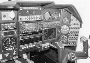
Big Box
As avionics go, the Avidyne is big. It is, after all, a full-blown, Windows-based computer. The overall size is the standard 6.25 inch rack width but 12 inches deep and 4 inches high. Surprisingly, the install is relatively easy, thanks to good support from Avidyne and well-thought out instructions. (Weight is 8 pounds.)

In addition to the box itself, theres an optional CD-ROM drive which is used for updating nav data and software and, for those so inclined, playing music CDs. This drive-retail cost $1495-can be installed permanently on the panel or elsewhere in the cabin or used periodically on a temporary basis to update the navigation data, which resides on the hard drive. Rather than install the CD-ROM permanently, we placed it in the baggage compartment and connected it via cable to the display unit.

For our trials in the Mooney, the FlightMax 440 was installed on the far right side and fit without undue gnashing of teeth. However, that wont be the case in some cockpits and any owner considering this unit will be well advised to pop the glareshield and have a careful look at whats back there. If wholesale remodeling of the panel is necessary, the cost of installation may escalate.

The first Avidynes were based on Intel 486 chips but the latest iterations have 166 Mhz MMX processors which seems plenty of horsepower for the task at hand. The display is an active matrix LCD which Avidyne claims is fully sunlight readable. We found this to be the case, even in direct sunlight on the ground, with the door open. Its also infinitely dimmable with the power knob, saving the nuisance of stepping through menus to set the brightness or relying on a sensor to set the brightness correctly.

Like the previous models, the FlightMax units use Windows NT as an operating system. Before you cross your fingers and gag, however, worth pointing out is that this is a highly customized and apparently stable version of NT, not remotely related to the bug-invested consumer versions of Windows 95/98.

Although we have in the past expressed serious reservations about having anything from Microsoft near an airplane, the Avidyne proved stable and relatively trouble free. (Other owners have told us as much.) Shortly after it was installed, our FlightMax test unit failed to boot. It was returned to the factory and repaired the following day. The problem appeared to be a dirty shutdown that corrupted the hard drive.

Although it was repaired right away, this does highlight one beef we have with this system: It runs like a computer, meaning the boot-up process is tedious and you cant merely switch it off. You have to follow a specific safe shutdown procedure or risk crumping the drive or file structure. If we had our druthers, it would be like any other box in the panel in terms of shutdown and start up.

Mega Map
Although the rest of the world is poised to catch up very shortly, the Avidyne has, in our view, the undisputed best moving map technology we have seen to date. It aces the Garmin 430/530 because its larger than the former and has the flexibility of displaying visual and paper chart detail that the 530 lacks.

Stored on the FlightMax hard drive are digitized versions of WAC and NOS low- and high-altitude IFR charts. With a few seconds of load time, these can be called up and the map projects the airplane right on the chart; instant position awareness.

Ah, but it isnt perfect. Those charts are raster scanned, not vector graphics. That means at scales much larger than about 10 miles, the details go to pieces, rendering them of limited utility. If you want to see your course line 200 miles down the road, cities and towns degrade to unrecognizable yellow blobs and surface detail is illegible.

Still, these charts have a nice wow factor and are useful close in to the airport. Just dont plan on reading an intersection name 50 miles away.The Avidynes strongest map feature is what it calls Navigator or NAV, an IFR-type map, projected on a black background with key features-airways, VORs, airports, special use airspace but no terrain-projected and decluttered by user settable scale. In our trials, this turned out to be a terrific feature, with detail sufficient for navigating the airspace hurdles of the New York area.

Making this an essentially set-and-forget feature is the fact that the Avidyne talks to the GPS-in our case, a Garmin 430-and projects a direct-to, full route or even an approach course as a magenta line on the NAV map display. Punch up direct New York to Miami and crank the scale out and you can see the course line painted on a map that includes the eastern U.S. Crank the scale back in and detail begins to selectively reappear.

Watch it, however. Occasionally, the Garmin and Avidyne dont speak exactly the same language. On a DME arc, for example, the Garmin draws in the arc all nice and tidy, while the Avidyne shortcuts it from the IAF to the turn in point, ignoring the arcs protected area with abandon.

Not a big deal but worth noting as just another rut on the road to the automated cockpit. In the not-too-distant past, we imagine some lone programmer trapped in his office cubicle had a revelation: Why are we putting all this junk into the code? Somehow, that idea has caught on and theres a minor move afoot to limit features to things that are genuinely usable.

Accordingly, the Avidyne has three numeric overlays for the map: A mega-detailed version, an everyday version and The Readers Digest large print version that will prove ideal for the presbyopic middle-aged geezers who can afford this box for their Barons.

The numeric displays-which have the usual suspects such as bearing/track, ETE/ETA, CDI, groundspeed and so on-are easily accessible via the single large concentric knob. (Scaling is reserved for the inner knob.) Theyre also customizable, as per the typical handheld GPS map.

We found the standard items were just fine when the mid-range numeric page was displayed. A fourth numeric page-the trip page-gives running ETE/ETAs and other tabular data and would be valuable for any pilot flying serious non-radar IFR and who needed to make periodic position reports.

The underlying map itself can be decluttered by scale using a clever grid set-up thats much easier to grasp than the scale values that Garmin uses. Again, once set-up, we found that the typical trip proceeds with little need to fuss with the Avidyne, save the occasional scale change. In terms of basic buttonology, Avidyne could give the rest of the industry lessons. Again, kudos to the programmers for resisting larding this thing up with the ridiculous options and preferences found in the typical Windows computer. (Were sure certification requirements had a hand, but lets give credit where its due.) A single key labeled menu calls up a series of submenus which appear over the map display. Thence, its merely a matter of following the various labels to set-up the desired function. Each of five keys along the right edge of the box has a soft function which changes according to menu.

We punched these things in random order trying to lock the thing up but never could, leading us to believe the Blue Screen of Death may never appear in an airplane. (We know, never is a long time, but the software really does seem robust.)

If radar, Stormscope, traffic or other externals are available, those very same keys are used to quickly toggle through the displays, as desired. With each function change, the concentric knobs automatically take on a different function, such as range adjustment for the Stormscope or tilt management for the radar. In our case, selecting the music CD function reverts the knobs and keys to volume and track select functions.

Although Avidyne doesnt push the music CD feature, noting that unlike car units, the player isnt vibration isolated, we found that it worked quite well, with good fidelity and no skipping, even when flown through light chop with the drive merely plopped on the backseat.

Radar, Lightning, Traffic
What Avidyne does, push, of course, is external sensors. At present, the FlightMax 740 will function as a color display for most Bendix/King color or mono radars. More interfaces are planned for this year, including hook-ups for the Collins line. No word yet if the popular Narco KWX-56 will also be included but our guess is that it probably will.

Traffic inputs include the BFGoodrich Skywatch system, TCAS 1 and Ryans TCAD, both the passive 9900B and the new 9900BX active system. The hooks and software already exist for this capability; you buy the hardware and youre good to go. Its hardly cheap, however.

The Skywatch option will add $20,000 to the invoice and the Ryan 9900BX is $19,200. The Ryan 9900B retails for about $14,000. For lightning, the BFGoodrich WX-500 is the only external sensor currently approved.

WX-1000 and 950s-not to mention Insights Strike Finder-dont talk to the Avidyne because they lack external output. If you want lightning dots, youll have to cough up $6000 for the WX-500.

If you already have a functioning Stormscope or Strike Finder, that may not be such a good deal. Other than adding the cell/strike mode feature the WX-500/950 has, the Avidyne doesnt bring much to the party in this regard. True, it does color contour the strikes but were not sure this worth the additional investment unless you need to open up an instrument hole or you dont already have a Stormcope. Even at that, its an expensive solution.

Costing It Out
Speaking of which, the Advidynes leading weakness, in our view, is its relatively high cost measured against delivered capability. When it came out of the blocks three years ago, it was close to being the only contender. Not anymore.

Bendix/King, Garmin and Apollo are all offering similar capability at competitive or lower prices, not to mention two other contenders, Arnav and Archangel. However, Avidyne leads the league in radar display replacement and its here and now, which is more than can be said for some of the other entries.

Lets look at the bottom line: At the low end, consider the FlightMax 440, with an installed price-including CD-ROM-in the $13,000 range. Add Stormscope and the total is about $19,000; add top-of-the-line traffic hardware such as the Skywatch or active TCAD and youll be shelling out close to $40,000, if you already have an IFR GPS. If not, add another $5000 to $10,000.

Frankly, these numbers begin to make little sense in an airplane costing less than $100,000 and will be marginal for some cabin class twins, unless the owner has money to burn.

More and more, then, the Avidyne is looking like an upmarket box best suited for late-model, expensive singles and newer cabin class twins and turboprops.

We think it deserves consideration in any airplane that already has radar but an aging display. The FlightMax 740 is pricey but offers unlimited future upgradeability and capability. We would sooner dump money into a multi-purpose color display than a tapped out radar indicator that only does one thing and not very well at that.

Final Impressions
We have, in the past, expressed serious reservations about any cockpit device running Windows. Although we still dont much like waiting for boot-up cycles, we concede that worries about software instability are misplaced. Thus far, the Avidyne seems to have a robust hardware and software combination which nets no complaints from us.

So, what do we have here? The most impressive, easy-to-use moving map technology weve tried; well-thought-out operating logic and virtually unlimited flexibility and upgradeability but a high installed cost compared to delivered capability and what the competition is currently pitching.

Other than high price, we have no significant reservations but we think any buyer should shop the other boxes-Bendix/King KMD 150, Apollo MX-20 and Garmin GNS 430/530, at least-before committing. And well be doing the same when these units are available for trial.

In the meantime, the market hardly lacks for choice in multi-function displays.

– by Paul Bertorelli


Also With This Article
Click here to view the Avidyne Checklist.
Click here to view MFD Comparisons.
Click here to view “The Burden of It All.”