Cockpit Apps for Droid? Try AviationMaps

None of the Android aviation apps match the top players on the iPad, but two small shops are closing the gap and the big iPad players are moving in soon.

The iPad cockpit revolution is a bit of a nightmare for us as we try to keep pace with the dizzying array of new and updated apps vying for space on your lap, and subscription money from your wallet. Now that Android-based tablets are on the market in force, the choice spectrum has widened further. Dizziness has turned into utter vertigo.

288

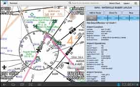
We’re diving in nonetheless because Droid opens up many possibilities for tablet size, integration of other hardware and lower price.

Naviator
Naviator covers all the critical bases: it offers a moving map with a background layer of VFR sectionals, TACs, or IFR en route charts. Approach plates are included, with an option to have them georeferenced (your aircraft position appears in the plan view) for an additional fee.

Basic weather and TFRs download automatically. METARs, TFRs and AIRMETs/SIGMETs appear on the map. TAFs appear only in the detailed airport information, which is basically the same data you’d get from the A/FD. That’s it for weather, so you’ll still need another app to get NEXRAD, NOTAMs and the like.

The moving map view shows your speed, track, distance to next, and ETE to next at the screen corners akin to the Garmin 496 family of GPS navigators. You have the option for layering on runway extensions, a compass rose and a predictor line showing where you’ll be in a user-determined number of minutes. (We like a three-minute line ourselves.) Naviator’s map will pinch zoom, but we found performance was inconsistent. The on-screen buttons worked better.

Charts are not stitched together, so you need to tell Naviator which chart you want to see, and which side if it’s a two-sided sectional. This can be cumbersome when crossing from chart to chart. It does, however, mean you can read the chart borders for information like MOA altitudes and effective times.

In a smart feature for tablets, there’s a button to toggle on and off a two-thirds/one-third split screen. This is a great feature for keeping the map in view while calling up airport information or viewing an approach plate simultaneously with the map. Naviator is smart about its screen taps: a short tap on an airport calls up quick info or lets you make a fast direct-to, with an option to show detailed info in that split screen. You can also add to your route this way.

288

That said, we think calling Naviator’s flight planning tools weak would be an understatement. Entering a long route is easy enough, although it doesn’t decode airways for you. But editing—particularly inserting a waypoint—is so cumbersome that it’s easier to just reenter the whole thing. There is an option for editing directly on the map, but it’s only a slight improvement.

Getting an approach plate in view is also a multi-tap process that could be streamlined. We do like Naviator’s quick expand for approach charts that lets you fill the screen at tap and then drop back to split-screen view. 

Naviator is a good value at $5/month or $50/year. Georeferencing is through a separate subscription from Seattle Avionics at $75/year. The app can be installed on two devices for one subscription price and there’s a free 30-day trial.

AviationMaps
Avilution’s AviationMaps is our top pick for an aviation app on Android, because it’s the most capable overall and the easiest to use, in our opinion.

AviationMaps has the FAA chart of your choosing base map that’s standard for these apps, with your aircraft and route superimposed. The app also lets you layer NEXRAD, METARs and winds aloft at various altitudes on the map. The NEXRAD looks great, but METARs are shown with cute suns or clouds rather than a graphically easy color code for VFR/MVFR/IFR/LIFR that’s become the industry standard. This makes reading weather at a glance a chore.

Toggling between map types is done through an easy pull-down menu, Charts are seamless, which makes panning easy, but Avilution has yet to add back in all the information from the margins back into airport information pop-ups.

Tapping an airport offers the same smart response you get from Naviator. A short tap reveals critical data with a second tap opening up the airport information page with all the details. A long tap offers route editing, but AviationMaps is smart enough to offer inserting, appending or direct-to for the waypoint. This makes route editing a snap.

AviationMaps has a 50/50 split screen option it uses well, allowing you to expand or collapse either half of the screen at a tap. Also available at a tap are screen lock, night mode and a search that can double as a nearest.

Flight planning is a mixed bag. There’s no way to enter your entire route with airways at once. You can, however, enter a couple of waypoints to get on an airway and then load the airway to an exit point. The problem is that Avilution doesn’t scroll to your position of entry so you’re scrolling through a lot of waypoints if it’s a long airway before you find your exit. There’s also no option to skip unnecessary intermediate waypoints.

288

One item we really like is that retrieving the weather for an airport (via the internet) pulls up a real trove of data including radar summaries, METARs, TAFs, the area forecast, NOTAMs, freezing levels, and TFRs. PIREPs are notably missing though.

Approach charts are accessed via the airport information and can appear in the split or full screen, but there’s no option to have them georeferenced yet. One slick feature is that approach charts you recently viewed get added to the list of charts you can select in the upper left of the map view. This makes for quick toggling to and from an approach chart as needed.

Two other novel features of AviationMaps are the runway-find function and the flight pad. Runway find gives you a top-down picture of your current approach angle to the destination runway—that’s runway, not just airport. The flight pad is sort of a digital kneeboard where you can record the ATIS information for departure and destination. It would take some practice to use it at the real speed an ATIS is read, but it offers quick access to relevant departure and arrival procedures. We’ll call it a not-quite-there feature that’s got potential.

Just like Naviator, AviationMaps is a great deal at $5/month. It’s not available on Google’s Android market as of this writing due to a conflict with Google. But you can get it directly from the developer’s website—a work-around you couldn’t do on a iPad without jailbreaking it.

It’s Not Pilot MyCast
Garmin’s new Android app doesn’t have a name yet, but it’s clearly an evolution of Pilot MyCast. We reviewed the early alpha build, and it’s definitely striving to be an equal to the quite-capable MyCast for iPad. (For those outside the computer cognoscenti, an alpha means it’s a work in progress.)

MyCast grew out of a flight-planning app into a moving map tool, so it’s no surprise this app’s weather and flight planning abilities excel. Enter your route as airport to airport or with airways and it does the rest. Filing the flight plan can be done right from the app—something no other app we tested could do. There’s a split screen, but it’s strictly for briefing data, with widgets for METARs, winds and other items. Scroll a time slider on the screen and the appropriate item for that point in your flight shows up.

288

The basemap includes the charts you’d expect plus WACs (handy when VFR and looking at large areas) and a plain background with state borders, which is good for weather analysis. You can layer PIREPs, NEXRAD and many other weather features on any chart, but only one layer at a time. In the air, the app shows your position, route and data in eight, user-configurable fields.

One big miss in the version we looked at is you can’t tap a map item, such as an airport, off your route and quickly get airport information. There is a nearest option for the direct-to function, but it would be nice to just quickly look up airport info before deciding to head that way. Pilot MyCast iPad version also lacks this valuable feature.

The app will include approach procedures, but they weren’t integrated yet so we can’t say how easy it will be to flip between an approach and the moving map. MyCast for iPad doesn’t handle this gracefully, in our view, so it’s unlikely to be a strong point. The Android app also lacks the more general weather maps and advanced flight planning of iPad MyCast, but these may be added to the final Android app.

Whatever its name will be, it will have Garmin’s relatively Cadillac pricing of $10/month or $100/year. Approach charts will be $50 extra, but they’ll be georeferenced. Garmin’s georeferenced Safe Taxi diagrams will cost an extra $30. The new app will be available about the time of Sun ‘n Fun. The current, simpler MyCast for Android will be pulled from the market, but those subscribers will get an upgrade that honors the single lifetime fee they paid. Approach charts or Safe Taxi will still cost extra.

Because we only saw the developmental alpha, we can’t pass final judgment on MyCast. But it’s absolutely a contender worth watching.

OpenFlightGPS
If you just need to see your position on an FAA chart and don’t care about instrument approaches, OpenFlightGPS might be for you. For a one-time fee of $30, you get WACs, sectionals, terminal area charts, low en route charts and even VFR flyways. Your aircraft position shows on all but the flyways.

These are not stitched-together charts, so the margins are there for the reading. You have to change charts manually as you fly from one to the other, but the app makes it simple with a one-tap way loading of the adjacent chart.

288

There are no frills here. You won’t get any more information about a waypoint than what you can read right off the chart. Flight planning? Uh, no. You can create a route by tapping points on the virtual paper and OpenFlightGPS connects the dots. Put the dots close to the waypoints you want.

Selecting charts for download is cumbersome in that it tries to immediately download each chart you want, rather than letting you select a set of states and download at once like other apps. Another lurking problem with OpenFlightGPS is that when Aeronav starts charging for charts, the company will need to switch to some subscription system or stop updating its charts. It’s worth remembering that the uncertain future of Aeronav data costs will affect the yearly cost of all these apps, iPad and Android alike.

Other Players
WingX has an app for Android, but it currently lacks a moving map, so it doesn’t make our cut for this review. They will build out to match or even exceed the capability of the formidable WingX for iPad. We’ll review it when those features are ready. Jeppesen has a Droid version of their app in the works, but won’t commit to a timeline or feature set.

What of app industry leader ForeFlight? “ForeFlight is not planning to port ForeFlight Mobile for iPad to Android tablets. A small team like ours can only tackle so much and keep quality high across all products,” says ForeFlight president Tyson Weihs.

Given that all these app makers save Garmin are small shops, competition plus the Damoclean sword of Aeronav pricing clouds the future of Droid apps. But for Droid tab owners looking for a cockpit companion today, there are good options.

Click Here