Shortly after the Boeing 777 appeared 10 years ago, we were given a courtesy tour of one of the sims intended to train pilots on the new airplane. Long before Avidyne or Garmin had wowed the GA world with primary flight displays, the Triple Seven was the real deal, with glass everything.
It was even supposed to have an electronic flight library for approach plates. But the airlines balked at the cost and the substitute was a 25-cent Office Max clip to tack an approach plate over the blank metal panel where the electronic display was to have been.
Surprisingly, a decade later, not much has changed. You can now buy a full-blown electronic chart library for your airplane via Garmin, Avidyne and Jeppesen but we havent heard a single buyer of these systems argue that theyre a substitute for lugging around a bag full of paper charts.
Supplemental only, one new buyer of an Avidyne C-Max system told us. To that, we would add this description of the human-machine interface: Nice, but needs work.
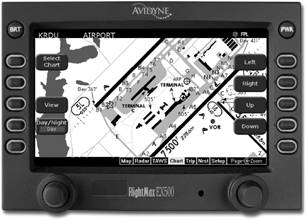
For this evaluation, we flew with the two leading panel-mount systems, Chart View running on a Garmin MX20 MFD and the Avidyne CMax system. We flew the CMax in a new Cirrus SR22 G2, in which it had just been installed.However, owners of Avidynes popular EX500 MFD can buy the system as a standalone, as some are now doing. The freestanding version of JeppView has recently been overhauled-to user kudos, we might add-and will run on laptops and tablets. we’ll look at those platforms in a future article. For now, we’ll focus on panel systems.
Two Products
With minor variations, both of these products do the same thing-display approach plates from a database. In our view, both are functionally hobbled in that they don’t really do what we hoped they would: Organize reams of approach plates into a seamless database that leaves us wowed by their intuitive ease of use. Instead, theyre more like your handy home reference library; there if you need it, but not always your first choice go-to.
First, the hardware. The MX20 has been on the market for five years and has established itself as a leading multi-function display. In our head-to-head shootouts, we have recommended it as a top MFD choice and since acquiring the product line from UPSAT in 2003, Garmin has kept it front and center.
In case you havent checked lately, the MX20 leads the league in external sensor capability, as shown in the chart on page 10. The Chart View function is just one of the bit players in a long and growing list of capability.
At $7225 for the basic box, the MX20 has always been and remains an excellent value, in our view. That sum buys an MFD with a crisp, color moving map, a terrain database and basic IFR enroute charts. Prices go up with capability and if you bought all the MX20 has to offer, youd be we’ll north of $25,000. The Chart View option is a $1995 add-on from Garmin, plus the cost of yearly revisions from Jeppesen, variable with coverage area.
Revisions are $965 a year for full U.S. coverage and smaller coverage areas are available, such as east or west of the Mississippi. The service also includes Jeppesen paper enroute charts plus JeppView software for printing out approach plates. Revisions are sent every 14 days, via mailed CD-ROM. The system includes a flash card reader/burner so youre on your own to remove the MX20 card, burn it with new data and reinstall it.
Avidynes chart player-called CMax-runs on both the FlightMax EX500 aftermarket multi-function display and the EX5000-type display used in the Entegra PFD systems. The EX500 is marketed much like the MX20 is, with a basic version selling for $8995 retail and more capable versions available at higher prices, as shown in the MFD comparison chart. For the EX500, the CMax chart option is a $2495 add-on, to include the hardware necessary to load with pricing and coverage of the revisions identical to the offerings for the Garmin product.
Avidyne has established itself as the market leader in MFDs that replace aging airborne radar indicators with state-of-the-art displays. As shown in the chart, versions of the EX500 support Collins, AlliedSignal and Bendix/King radars. For aircraft equipped with these radars, the EX500 may be the only practical choice due to space considerations in a tight panel.
In Flight
We used the Avidyne version of this software in a Cirrus SR22, displayed on the Entegra PFD. Functionally, for charts, it works the same as the EX500 version and, overall, we think the operating logic is simple and easy to master. The charts are accessed via the chart page on the MFDs main selection bar. From there, a series of soft keys appear commencing with a select-chart button which pulls up a list of available charts by name. Once the MFD has a valid GPS position, the system defaults to the airport diagram and depicts the airplanes position on the airport surface.
In our view, this is where the system shines. Jeppesen airport diagrams are clear, we’ll labeled and easy to read. With the geo-referenced airplane symbol, getting lost or missing a taxiway should be all but impossible, not to mention avoiding a runway incursion blunder. After landing, the system again defaults to the airport diagram once groundspeed drops below 50 knots.There’s a zoom button for scaling charts up or down and a view button which toggles from one segment of the chart to another, say from the minimums box to the plan view and so on. Map pages-the plan view, for example-are zoomable while information pages in headers are not. There are pan buttons to slew around the current view.
For actually flying an approach, the JeppView software is less impressive, in our estimation. Selecting the right chart is easy but-and we see this as the main failing of the system-the display/software combination is set up to accommodate the look and feel of Jeppesen paper products. Because of the displays aspect, you cant view the entire plate in readable format so, using the view key, the software steps you through various segments of the plate, beginning with the header or briefing strip, the plan view, the minimums box and so on. The header, profile and mins view also include a thumbnail plan view, geo-referenced with the courses magenta line.
This all sounds logical enough but heres the problem: When you visually scan a paper approach plate, even though you review it in a disciplined way, you still parse the data somewhat randomly. With paper, you merely scan the sheet, move on, and re-scan later, as needed. But Jepp-View demands the distraction of a keystroke-or more-to step through the pages until you see the data you want. In short, the display mimics the look of paper but without the advantages of paper. This is progress?
Well, yes, we suppose so. Position awareness directly on the plate is terrific, as is knowing where you are on the airport surface with confidence.But frankly, we were hoping for more, in the form of a system that wouldnt force the user to conform to the machines foibles. One Cirrus pilot told us he got around this by writing critical information on Post-Its stuck to the panel, a practical solution that seems vaguely ridiculous to use with a $2500 digital library.
MX20
Even before Garmin bought UPSAT, the MX20 had Chart View, a version of JeppView customized for this MFD. Its operation is quite similar to the Avidyne version in principle but it varies in detail. Once the software is loaded-it comes aboard via a flashcard-the charts are accessed via labeled softkeys.
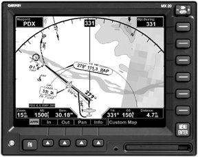
Unlike the Avidyne unit, the MX20s base map includes IFR enroute charts as a display option; selecting VFR mode displays sectional-like information, albeit not as detailed. Weve found the enroute charts to be marginally useful but in no way do they replace paper enroute charts. The display view is simply too limited, in our experience.
As with the Avidyne, the MX20 has a select airport/select chart function to point the pilot at the desired procedure. In Garmin-speak, the plates can be viewed dynamically or statically. If the former, the plate geo-references aircraft position, as long as the correct approach has been selected and activated in the GPS navigator feeding the MX20. If the plate is viewed statically, the display looks just like the paper approach plate it mimics but, again, you cant view the entire thing at once at readable scale. You have to select the chart, then use panning keys to slew around the display.Zooming keys permit zeroing in on details and in static mode, you can zoom the data boxes, which you cant do with the Avidyne version. In addition to splitting the screen, the MX20 can also split out portions of the plate-the mins box, header and so on-for closer examination.
We see plusses and minuses in this way of displaying plates. On the plus side, if you can get used to the Avidyne screen organization logic-and were not sure we could-the information is there in usable format. Minus: You have to stroke some keys to get at, often at a time when you cant afford the distraction. The MX20 suffers from a similar limitation thats further aggravated because in dynamic mode, you cant pan around the displayed plan view of the chart. However, pressing the info key allows viewing the plate header, profile and mins boxes, again by pushing more softkeys.
If all of this sounds like more work than scanning a paper chart, it is.Further, it can be frustrating finding what you want when you want it. In flying both of these systems, we were struck by the overwhelming urge to have the paper chart to find information we wanted in a hurry.
Paper Forevermore
To be charitable, we would characterize the process of keeping these flight libraries up to date as awkward and expensive. Jeppesen sends revisions on a 14-day cycle on CD-ROMs. To update the Avidyne CMax, you transfer the data to a USB Zip disc, then carry that to the airplane and plug it into the front of the unit, which is equipped with a USB port. Although we observed the Zip disc transfer, we did not actually update the unit. Cirrus demo pilot Justin Dillon, whom we flew with in the SR22, reported no problems with revisions.
Buyers of the MX20 get the software and a USB-based flash card writer. You can buy an extra card and swap them out or remove the card from the MFD, burn the new data, then replace the card.
So whats right and whats wrong with these systems? First, the plusses: The charts are bright and crisp. Its a definite plus to have them available in electronic format at the touch of several keystrokes, if not a single button. The hardware works as claimed.
Whats wrong, in our view, is that Jeppesen is maddeningly clinging to the notion of using sophisticated avionics as mere word processors to show facsimiles of paper plates on an electronic display ill-suited for the job by dint of aspect and size. Rather than simplifying the pilots life, this forces stepping through hoops to accommodate the machines limitations. In our view, it should be the other way around. Further, you’ll still want paper as a back-up so you must confront the dilemma of printing plates using JeppView-a nuisance-or buying a paper subscription, a nuisance and an expense.
If were ever to transition away from paper, whats needed is a new paradigm that places critical approach-related data on the MFD independent of how a paper chart is organized. In our view, paper charts have too much extraneous data and its time to rethink them to accommodate the capabilities of MFDs.
As for the systems reviewed here, were lukewarm on their value. The hardware is definitely up to snuff but we wish Jeppesen would rethink the software. In the interim, we agree with those owners who tell us electronic flight libraries simply arent ready to replace paper yet. So, for the moment, flight libraries may be nice to have, but because you still need the paper, our view is that their value isn’t yet commensurate with their cost.
Also With This Article
“Checklist”
“Wanted: A New Way of Viewing Charts”
“MFD Options Compared”
Contacts
Avidyne, 800-284-3963, www.avidyne.com
Garmin International, 800-800-1020, www.garmin.com
Jeppesen, 800-621-5377, www.jeppesen.com