by Paul Bertorelli
Some years ago, a bureaucrat in an airless warren at the FAAs Washington headquarters hatched a profoundly bad idea: he thought the FAA should write some rules to govern how portable GPS navigators were used in aircraft. Maybe some design standards for yoke mounts, flight testing of Velcro patches, that sort of thing. Fortunately, this loser never got beyond the interoffice memo stage but we have to think products like the new Garmin 296 give the FAAs deeper thinkers throat-searing heartburn.
The 296 is being rolled out as we go to press-at the relatively high retail price of $1795. The eye opener is that it has, in some form, some of teh features found in the top-end Garmin GNS530 IFR navigator and, get this, the terrain depiction and warning detail planned for the new G1000 primary flight display system. Its nothing like legal TAWs, of course…wait, what are we saying? Its a lot like TAWs, providing vaguely similarly functionality without the stratospheric price tag.
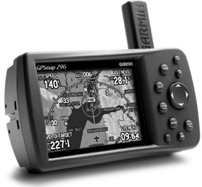
If youre familiar with Garmins recent top-of-the-line entry-the GPSMap 196, the 296 has the same capabilities plus some new features, including a sharp-as-a-razor color display and a faster processor.
If you buy the available ground navigation package-an additional $349-you get CDs containing detailed street maps for the entire U.S. and the navigator is not only capable of plotting shortest distance/least time routes, it will spew out turn directions aurally through a speaker in the accessory plug in any of 11 languages.
Evolutionary
Garmin has, by degree, pursued both a revolutionary and an evolutionary design philosophy in portable GPS. The diminutive GPS90 was an example of the former. Even though it evolved from a marine unit, when the 90 hit the aviation market, no one had seen anything quite like it. The same applies to the 195. But the 296 is more evolutionary, building on the 196 released two years ago which was itself a developmental offshoot of a marine unit.
What the 296 brings to the party is primarily a sharp color screen-TFT technology similar to the GNS530 with 256 colors-incrementally improved operating logic, a faster processor (200 MHz, according to the spec sheet) and an extensive terrain database that puts the color screen to good use. Although we honestly think the thing would look and work just fin with a monochrome screen, the color is a must in adding functionality to the terrain warnings.
Sizewise, the 296 is almost identical to the 196 but side-by-side, we noted that its 3/16-inch narrower and the screen area is 1/4-inch smaller in the vertical dimension. The control set is identical-slightly smaller buttons-so if youre comfortable with the 196, you wont have any trouble with the 296.
In the past, Garmin has approached marketing and price stratification from about every point of the compass. Some products-the GPS III Pilot, for instance-were sold la carte, with minimal accessories while others have been shipped with all the goodies.
At $1795, the GPSMap 296 ought to and does include almost everything. You get the yoke mount, a portable charger, ships power cord and a USB data cord. A case to carry it all is an $89 list price extra but as of press time, it appears that some retailers are throwing in the case for free so shop around.
The portable charger, by the way, is a must because the 296 is one of the few Garmin products that wont run on off-the-shelf batteries. Its primary power supply is an 8.3-volt lithium ion pack of the sort thats standard equipment in notebook computers and PDAs. Garmin says it will last between 5 and 15 hours of normal usage, depending on the backlight level. (We got six hours out of our first charge.)
You can buy a spare for $59 or running the navigator off ships power-12- or 24-volt-keeps it constantly charged. The display is 1/2 VGA or 320 by 480 pixels, compared to the quarter VGA (320 by 240 pixels) used on the GPSMap 196 and 160 by 305 used on the ColorMap 295, Garmins first color portable for aviation.
What a difference a few pixels make. The display has an almost three-dimensional appearance thats as sharp as any weve seen thus far. Garmin tells us its a transflective display, which means it requires less backlighting and thus less power than transmissive-type displays used on the 196 and 295.
Without backlighting, those displays appear black while a transflective design uses ambient light to help illuminate its detail, thus consuming less power.
Were told that Garmin used most of the 256 colors available with this display and it fell back on the considerable research on color selection done for the G1000 primary flight display. Side-by-side photos of the two screens look virtually identical in brightness, sharpness and detail. In bright light, we found the color subdued but even in sunlight, the detail remains readable.
In daylight, you might ask, hey, is that color? At night, its, hey, is that color? Speaking of night, the 296 automatically switches from night to day mode according to local sunset/sunrise time.
Thanks to Garmins improved GPS engine, the 296 is happy operating with its onboard stick antenna and this will work fine on the yoke in most aircraft. However, to avoid obstructing your view of the panel, the remote antenna-a puck type design-is recommended. As for the yoke mount itself, its the same provided with the 196 and, in our view, is Garmins best effort thus far. At 12 ounces with battery and with its rectangular form factor, the 296 is suitable for yoke mount, less so for the glareshield; its just a little too large and shaped wrong.
For the car, Garmin provides a swivel mount that attaches to the dashboard with either an adhesive pad or a bean bag weight. It has a quick release so the unit itself can be easily unsnapped and then snapped into the yoke mount in the airplane.
If you prefer to leave this stuff semi-permanently wired for both the car and airplane, you might need extra power cords for ships voltage and perhaps an extra antenna. Switching from ground to air mode-or to marine mode-is done via a quick menu step-through.
Buttonology, Database
Although the operating menus have been enhanced from the 196 to accommodate new functions, the 296 has the identical control set, including a page key to navigate the primary screens-there are five of these-a dedicated menu key, zoom in/out buttons, a nearest button and a dedicated direct-to button.
A centrally placed rocker is used for scrolling through pull down menu lists, for panning/pointing on the map pages and for alpha-numeric entry. With the additional processing load of color, we expected to see some screen refresh delays. But no, when scaling from one map range to another, the screen populates all the icons, terrain detail and map icons as fast or faster than does the 196. Put this thing side-by-side with a circa-1996 GPS 195 and the older unit is positively glacial.
As visible in the photos on page 10, the map shows detail comparable to Garmins new G1000 PFD, which is to say it puts the 430/530 units to shame. Were talking about sectional-like detail here, terrain in shades of green, yellow and red, according to elevation, rivers in dark blue, roads in black and special-use airspace in magenta or blue.
Being a child of TAWs thinking-terrain awareness and warning system-the 296 has a page devoted entirely to terrain depiction; think of it as radar for dirt and towers. In addition to the terrain database for the entire U.S., the 296 has the standard Jeppesen aviation database, including named approaches-final fix and runway waypoints only-runway extensions and runway end data, plus the usual aerodrome background noise such as runway length and frequencies. The runway extensions look like ILS feathers and are available whether the airport has an approach or not.
Flight Screen, Ground Nav
The GPS 196 pioneered the notion of a GPS-driven flight instrument page. The 296 has this page too, with capabilities identical to the 196, save for color and one small change. When configured for use in a glider, the digital altitude display becomes a digital vertical speed display. Not quite a variometer, but you get the idea.
As with the 196, all of the instruments-airspeed indicator, altimeter, HSI and VSI-are driven by GPS rate-of-change data. That means airspeed is really groundspeed, altitude is GPS altitude above the mathematical spheroid and heading is really ground track.
Interestingly, for those who worried that GPS altitude would someday run them into the dirt, Garmin has upped the ante a bit. Since it has no baro input, the 296 depends entirely on GPS altitude to issue warnings about terrain it knows is out there based solely on its position in space.
Our tests of the 196 flight page showed it to be good enough to fly in the clag without reference to iron gyros and we have no reason to believe the 296 isn’t just as good. If anything, its a little better by dint of the color display being sharper and easier to read. Not that were recommending using this thing for real-world IMC flights, but our tests showed it would be adequate for back-up.
The display lacks an attitude indicator so youre on your own to interpret that from rate of change in airspeed and altitude. There is a turn coordinator and its sensitive enough to maintain controllable if not perfect wings level flight.