Garmin GPSmap 696: Big Screen, Easy Logic

Garmins first large-screen GPS navigator has all of the 496s features, plus a chart and plate library. For a princely price, its a step up in ease of use and utility.

The new definition of the word futile is to ask if the world is really ready for a $3295 portable aviation GPS. Its futile to ask because Garmin will find no shortage of buyers for the new GPSmap 696 it introduced in early November. In addition to being a first-rate engineering company, Garmin also understands how customers are willing to spend their money, thus theyve put just enough gotta-have-it features into the 696 to make sure great droves of them will.

Still, the 696 is a curious product-definitely fowl, but with vestiges of fins to suggest fish, too. In other words, its nearly the size of an electronic flight bag, but it definitely isn’t one, even though it has some EFB capability. Buyers who might

Garmin's GPSmap 696

otherwise consider an EFB will want to consider the 696 before buying.

Impatient buyers whod caught whiff of the next big thing from Garmin and bought GPSmap 496s because they couldnt wait can only sigh and think about an early trade-in. Herewith is our analysis of whether a trade is worth it.

New Hardware

Although it marches forward in occasionally bold strokes and has enough developmental dollars to buy a small country, Garmin has traditionally leveraged its hardware platforms across several markets. Virtually all of its aviation portables have sprung from either marine or terrestrial hardware and if this has yielded compromises, we havent noticed. The 696 represents a departure, for it is purpose-built for the aviation market. In fact, if youve seen the G300 in the Cessna Skycatcher prototype, youve seen the 696, after a fashion. The G300 evolved from 696 development.

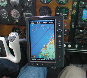
Garmin is launching two versions, the 696 ($3295) with XM datalink weather and the 695 ($2695) without weather. Right out of the box, the first impression is of robustness suitable for driving nails. At 2.2 pounds, the thing is heavier than it looks and at 7.7 by 5.7 inches, its the largest aviation portable Garmin has made.

In fact, its large enough that buyers will want to think carefully about how and where to mount it. The provided RAM mount is well-designed and stout, but the unit still takes up enough space to shade instruments or controls. We flew the 696 clamped to the center post of a Debonair and found it quite dominant, spacewise.

Garmin's GPSmap 696

The 696s processor is a Garmin proprietary development, not a chip from the computer commodity market. And thats what separates the 696 from the EFB world-it wont run the third-party programs that most EFBs will. What Garmin gives you is what you get.

The WVGA screen is the latest iteration of backlighted LCD technology at 480 by 800 pixels. Display area is 6 1/8 inches high by 3 3/4 inches wide, making it 23 square inches compared to 7 square inches for the GPSmap 396/496. That means details like navigation data, airport symbols and charting information are rendered in wider context, if not larger. Colors are vivid, but that comes at a price: the display runs on the warmish side and requires substantial power. About 13 ounces of the 696s weight is given over to a removable nickel-metal hydride battery than snaps into the back of the device. Garmin says this will run it for 8 hours with reduced backlighting or up to 2 hours if the remote XM receiver is plugged in. Clearly, this device is best operated on ships power. Either way, the display is dimmable almost down to nothing for night ops.

New Controls

In our view, the most welcome aspect of the 696 is the softkey/joystick control architecture. For all its innovative brilliance, Garmin has retained much of the basic operating logic it introduced going back to the GPSmap 90 in 1995. On the plus side, the logic is simple and transferable unit to unit-if you could operate a GPSmap 90, you could manage a 196, a 296 and so on.

On the other hand, this has also wedded Garmin to a now-clunky four-point rocker key data entry design thats tedious to use compared to the state-of-the-art touchscreens found in Garmins own terrestrial navigator line. Weve long thought it was time to move on and now Garmin has, with softkeys and a joystick on the 696. Anyone who has used the G1000 (or a 530) will be right at home with the 696s control set and anyone who hasnt will figure it out in about five minutes.

Arrayed along the bottom of the bezel are five softkeys that control map page selection-VFR, IFR with charts, topo and so forth. These are labeled with a context-sensitive menu right above each key.

From the map pages, you can scroll through four additional choices-waypoint, weather, XM audio, satellite status-by rotating the FMS joystick. This is like the small concentric knob on the 430/530. On the waypoint and weather pages, the softkeys transition to additional choices, each clearly labeled.

The joystick comes into its own when entering data. For entering a flightplan, for example, you rotate the knob to select characters and click the joystick sideways to advance the cursor. This is much faster than the rocker key and better than the dual-knob dance on the 430/530. Its all figure-outable without cracking the manual. Stuck? Holding the clear key down gets you back to the main map page, which 430/530 owners will do by instinct.

Along the right side of the bezel are six keys that havent changed in 100 years-enter, clear, menu, flightplan, direct-to and nearest. Rather than discrete scale-up or down buttons, the 696 has a single rocker for map scale changes.

Garmin has also thoughtfully maximized the advantages of the larger screen. For example, when you press the nearest key, half the screen is given over to a

Garmin's GPSmap 696

tabular list of airports, navaids and such, but the lower half depicts a detailed map and as you cursor through the choices in the tabular list, the map draws a line toward that selection. Added to the nearest function is nearest reported weather-handy if youre droning through the clag wondering just how bad it is down below. Beats fumbling for an AWOS freq, although thats presented, too by expanding the entries or clicking back to the waypoint page.

Garmin has retained the highly customizable function for the screen display. Using the menu key, you can select from six page layouts, to include an HSI with various, selectable detail in each data field. There’s more than enough flexibility for any user, in our view. The flight panel page-first offered in the 196-can be toggled on or off with a softkey or docked permanently using a menu stroke. The main menu-accessible by a second push of the menu key-calls up weight-and-balance functions, an E6B, a personal aircraft profile page and flight and track logs.

Charts and Plates

The big new addition here is the chart and plate function. Built into the database are low and high altitude airways, plus approach plates, departures and arrivals for U.S. airports. These are derived not from Jeppesen data, but from the FAAs NACO charting system, although the 696 does use Jeppesens navigation data. On screen, the plates look just like NACO plates, which they should, since theyre scanned from those products.

For enroute flying, both low- and high-altitude charts-or, more accurately-chart nav data are available. These appear as depicted lines, with airway labels in reverse boxes. Intersections are shown and cursoring over them reveals the name.

Using the joystick pan function, you can easily pan for hundreds of miles to follow an airway. Unfortunately, what you cannot do is build a flightplan using airway designations, a feature that earned Northstar a cult-like following more than a decade ago. This capability remains curiously absent from some of even the most sophisticated FMS equipment and were not quite sure why, as owners tell us they want it. Despite GPS-guided everything, clearances are still specified by airway.

As with previous Garmin products, approach procedures can be amended to flightplans, either by name or fractionally by waypoint.

Although the 696s screen is large, its not large enough to accommodate a full 5 by 8 standard NACO approach plate, so plates appear at about 70 percent full size. What this means is that the typical 40-something presbyope wont be able to extract the fine-print data from the plate without bumping up the scale with the range rocker.

You can then use the joystick to pan around the page to see the required detail, such as minima boxes or course data. Although this isn’t necessarily the ideal solution, in our view, its about as practical as these things are likely to be for the time being, until someone invents a new electronic-only chart format. Worth noting is that the plate function disables itself six months after the expiration date. So at minimum, you’ll need to do one update a year ($95) or buy a subscription for $395.

Garmin's GPSmap 696

We think the 696s iteration of paper charts is more than adequate to serve in lieu of carting around paper. One feature thats missing from the 696s approach plate function is geo-referencing for the plates, something Garmin says isn’t in the works . We think some buyers will want this, but we don’t see it as a significant shortcoming because the main navigation map depicts the aircraft relationship to the course line and fixes via standard magenta and white lines. Using the joystick, one click clockwise pulls up the plate, a click back goes to the nav map.

The 696 does geo-reference when the airplane is on the airport surface. Beginning with the GPSmap 496, Garmin has offered its SafeTaxi feature, which plots the aircraft position relative to taxiways, runways and airport surface features. SafeTaxi is an automatic background feature that can be turned on or off, but it applies only to airports that have a full-size airport diagram, not smaller airports where only a thumbnail diagram is provided. In addition to depicting taxiways, SafeTaxi also highlights so-called hot spots-areas likely to confuse pilots because of complex layouts or screwy turns.

Map refreshes for charting are quick-no waiting for the screen to paint, although a new chart takes about two seconds to initially load. Well mention that the 696 Garmin sent us experienced numerous uncommanded reboots. Garmin had us send an error log and at press time, they told us their analysis had discovered and fixed a software bug. Were mentioning this only in passing, since Garmin has established a long history of setting right any product shortcomings.

Conclusion

So, what do we have here? The GPSmap 696 is classic Garminesque, which is to say it represents substantial but incremental improvement over what went before it, buoyed along by the companys usual superb engineering. Depending on how you value the larger screen and the addition of a chart library, the 696 is to the 496 a larger leap than the 496 was to the 396. In our view, the 396 was the last big game-changer portable.

Compared to the 496, we think the 696 is a sober, well-considered application of Garmins best interface thinking, specifically the softkeys and the joystick. Taken together, these materially improve ease of operation. The chart library is a plus that will alone win over many buyers, while others will be blown away by the large screen. (don’t forget the trade-off-finding room for it may be a challenge.)

Whats missing? We think many buyers will want geo-referenced approach plates and, frankly, we were expecting to see touchscreen control on this device. Weve recently tested two of Garmins road navigators which are touchscreen controlled and these devices are miles ahead of softkeys and joysticks, even though the latter are an improvement on the old rocker key. But Garmin says it wanted to keep the 696 rooted to the familiar operating logic of its other aviation products.

We suspect that the 696 will find a number of niches, including the gadget guys who want anything as long as its new and buyers with an older but competent GPS-say a KLN89B-wishing for a sophisticated upgrade, but who arent willing to spend $10,000 to get it or even $4500 for a full-up EFB.

In that context, $3295 for a large-screen moving map doesnt look quite so expensive. Owners who already have datalink weather or those who just don’t want it may find value in the $2695 695 version of this product, but otherwise, we think the higher-priced version is the way to go.