by Paul Bertorelli
(article PDF here)
Whether by disposition, genetics or just plain ill temper, we admit to being complainers. When we review products, we always look for the warts the ad copy so carefully skirts and we often wish for features an otherwise perfect product just doesnt have. For instance, when we reviewed Garmins iQUE PDA a couple of months ago, we thought it a yawn because it didnt incorporate datalink weather. And no Bluetooth? How simply inadequate.Secretly, we thought no one would ever figure out a way to stuff datalink weather into a dedicated portable GPS.
We also admit to a certain cynical lack of faith, for in its new GPSmap 396, Garmin has definitely figured out the weather thing and, in the process, probably revolutionized the world of portable GPS. In our view, this product has such over-the-top, well-executed features that it qualifies as one of those once-a-decade products that phase shifts everything to the next level in terms of capability and value.
More significantly, we think the 396 opens the door to the next round of development that will see larger, lighter displays that consume less power, require fewer wires in the cockpit and provide all the external sensing you could want or need in a single lightweight package. Watch for that; the 396 is the precursor. But while were waiting, heres a detailed look at the GPSmap 396, one of the most remarkable products weve seen.
What It Does
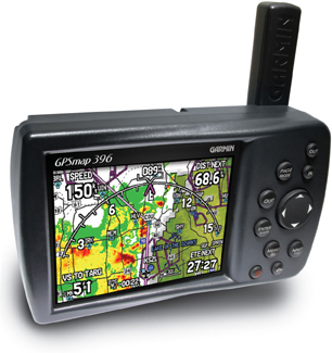
In a single $2695 package-$2495 discounted-the GPMmap 396 provides GPS navigation with approaches and vertical guidance, ground-based automotive navigation with turn-by-turn voice directions, marine mapping, WxWorx datalink weather through XM Radio, XM Radio audio entertainment, traffic display through a Garmin GTX330 Mode-S transponder and frequency channeling for the Garmin SL40 navcomm, TAWs-like terrain warning with voice alerts and a full-up flight panel page that weve found suitable as a back-up if the vacuum-driven gyros roll over.
The accessory package includes a yoke mount, power cabling, remote-mounted XM and GPS antennas, a charger and PC cabling. For its introduction-scheduled for EAA AirVenture at OSH-Garmin was also throwing in a car navigation kit, which consists of a beanbag dash mount and the City Select mapping software. (Sorry, youre on your own to buy the boat maps.)
If this sounds like a lot of money for a portable GPS, it certainly is and were sure some buyers will balk on price alone. But the 396s capability is so sophisticated that we think this product will be, by far, Garmins best seller ever. And therein lies a tightrope for Garmin. If the early buying frenzy spins out of control, Garmin will have to deliver a potentially enormous number of these things in fairly short order to keep the I-want-it-now crowd from blogging the thing senseless. (See page 2 of the September issue of Aviation Consumer for an example of how this can happen.)
Between its Taiwan and U.S. plants, Garmin has plenty of production capability, but for the 396, its depending on XM Radio to provide the radio chips. we’ll be curious to see if XM has a clue about the sort of eruptions in demand Garmin is famous for. (Presumably, a version of this product will go into marine and automotive markets, as well.) Supplies in quantity were expected sometime in September or October.
Speaking of XM, you’ll be writing them some checks. For the data side, WxWorx offers two tiers of coverage, one at $29.95 a month and a second at $49.95, plus a $75 activation fee. The lower-priced service includes NEXRAD and some basic services such as METARs and TAFs, while the higher-priced version has a wider range of products. (See the May and July 2005 issues of Aviation Consumer for a detailed analysis.) XM entertainment service costs $12.95 a month, but there are breaks for multi-year sign ups. In our view, you’ll want the tunes, so figure between $514 and $754 a year in data/entertainment charges. If you already own an automotive or home XM, you can also get family plan pricing for $6.95 for each additional radio. Not a bad deal.
The Hardware
For anyone whos flown it, datalink weather is terrific. But its not without its bugaboos. Panel-mount versions are expensively beyond reach of many owners and although portable versions have proven good performers, theyre also a pain in the butt to use, because the cockpit ends up festooned with wires, an XM receiver and a laptop or PDA. None of this stuff is ideally suited for the cockpit, so while we love our WxWorx running on a laptop, we loathe the chore of setting it up.
The 396 confronts this head on. In its simplest configuration, which is running on the internal rechargeable lithium-ion battery, the 396 requires only one external connection: the XM antenna/processor, which Garmin calls a GXM30 Smart Antenna. Its a disc 3 3/16 inches in diameter and 1 inch high which simply sits on the glareshield in view of the sky. Its powered by the receiver through a USB-type port and collects the signal for processing inside the receiver. The XM audio also comes in through the GXM30 and there are two XM chips, one for data, one for audio. Fortunately, you only need one XM ID number and that simplifies setting up the account.
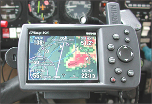
This design radically reduces the complexity of wiring the cockpit for XM datalink because youre confronted with fewer wires and gadgets strewn about the cockpit. During operation, the antenna gets detectably warm to the touch so its drawing some serious current. Garmin says the battery should last in this configuration for about four hours-we saw less than two hours from a fully charged battery-so we think running on ships power is a must. (Voltage range is 11- to 35-volts DC.)
If the 396 is placed in the yoke mount, which it really should be so the wiring can be tucked away, one additional cable is required to power it.Although the 396 has a remote GPS antenna, we found that it doesnt always need it. The GPS receiver is happy with the onboard flip-up post antenna.However, watch it here. In our Mooney, the glareshield occasionally shadowed the antenna enough to reduce GPS coverage to 2D only. In this state, the 396s terrain warning wont function and a red X will appear across the terrain page. You need 3D navigation, so in some airplanes, the GPS antenna may be necessary.
The 396 shares the identical form factor with its predecessor, the GPSmap 296. However, there are some internal changes and they are noticeable in performance. First, the display: Its a transflective design, like the 296, with 256 colors and 480 by 320 pixels. The size is 3 1/4 by 2 1/8 inches.
Garmin tells us the display is an improved version with more backlighting and less reflectivity. We found the display colors noticeably denser and brighter than the 296s.In direct sunlight, the 296 washed some and so does the 396, but far less so. We don’t think anyone will have trouble seeing the screen in any lighting, although with sunglasses on, expect some degradation.At night, the minimum dim setting is low enough to avoid the glowing orb phenomenon and as in the 296, the viewing angle is adequate but not wide.
To accommodate weather and other processing needs, the 396 has double the memory of the 296, 64MB versus 32MB. The internal battery is also improved, providing about 10 percent longer life. There’s no alkaline battery option, so if youre obsessive about back-up power, buy a spare battery or keep the thing fully charged at all times, which it should be if its running on airplane voltage. One additional hardware variation on the 396 is a standard audio jack under a weather wrap on the backside of the unit. This will accept a stereo headset with a standard plug or it can be interfaced into the airplane audio panel.
Overall, the hardware is we’ll designed, whether used with the yoke mount or not. When the yoke mount is in place, the wires can be routed out of way, vastly reducing the hassle factor. A couple of minor points: the USB jack for the Smart Antenna is nicely right-angled for minimal projection but its a tight fit and requires care to remove because of its juxtaposition in a notch in the units curved back. The same applies to the power/data cable. If either of these are forced, we could see them getting bent or broken.
The power data cable does double duty, powering the unit and providing a couple of wires so that TIS traffic output from a GTX330 transponder can be displayed. The same two wires provide the link for SL40 frequency channeling. Were not sure how many owners will actually use the traffic display since, presumably, if you bought a GTX330 in the first place, you can already display traffic on a GNS430 or 530. But if you want the capability, its there for the cost of your avionics shop doing a little wiring to the transponder. Garmin believes that the 396 interface may sweeten the deal enough to convince some owners to buy a GTX330. We didnt have time to wire the connection to our 330, so we cant comment on how we’ll the traffic function works.
Nav Functions
We covered these in detail in the GPSmap296 review in the May, 2004 issue of Aviation Consumer. Essentially, the 396 has the same capability and the same operating logic, which is to say straightforward and easy to use. Because of added functionality with no additional buttons-other than label changes-there are differences in menus and button sequence. But anyone familiar with a 296 will have no trouble with this product. We had to refer to the manual only once, to look up the means of switching from auto to aviation mode. (Hold down the menu key until a dialog box with the three choices appears.)
In aviation mode, there are four pages, one for navigation, one for terrain display, the flight instrument page, which depicts an HSI, an altimeter, a VSI, a turn coordinator and an airspeed indicator, an active route page and a numerical position summary page. The satellite status page is available through a separate menu. The nav page displays the usual stuff and can be customized to include overlaid numerical data whose fields can be further customized, to include new fields from weather and XM data. You can put the altimeter setting of your destination airport into a field, its dewpoint or winds, for instance. The main map page is an arc view, with data overlaid in the far corners, a basic mimic of the GNS530 arc-view page.
The navigation page displays the weather graphically and it can be easily toggled on or off by holding down the menu key or it can be turned off entirely through menu selection. The map can be easily decluttered-and at times, with the weather displayed, it needs it-by sequential stabs at enter key. There are three levels of declutter but the weather depiction remains after youve stripped away the nav symbology.
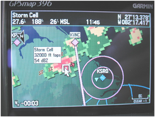
Like the 296, the 396 is WAAS-capable and its database contains the principle fixes for flying approaches. on the nav page, each airport runway has extended centerline feathers that appear at any settable map scale. These are helpful in finding and lining up on a runway end in hazy weather. With the added weather display, the 396 nicely shows how a storm cell relates to the final approach course and the airport itself.
Weather
Now, to the good stuff. The 396s weather display is based on the WxWorx product, but Garmin uses its own software. Anyone who has used WxWorx will be familiar with the basics, but Garmin does some things differently. For example, since it combines navigation and weather in a single small screen, the elements of the weather display can be toggled on or off or set to appear at certain scales and not others.
We preferred to have the NEXRAD display at all scales but the satellite mosaic-not especially useful most of the time-at 50 miles and greater.Similarly, lightning and storm cells can be set to appear at any desired scale. Again, you need this flexibility because the display is small and easily crowded.
In addition to NEXRAD imagery, the 396 will also display graphical METARs, surface winds and pressure, visibility, fronts and county weather warnings.These, too, can be set to appear at any desired scale from 20 feet to 800 miles. The scaling really needs to be used judiciously due to the screen size. If you work at it, you can clutter it to the point of uselessness.
To read a local textual METAR, slide the cursor over the graphical METAR symbol and the text pops up. Tapping the enter key brings up a domestic decoded version of the raw METAR. This information can also be accessed through a weather tab on the nearest/find page. That page also displays a list of graphical METARs and tells whether each airport is under IFR, MVFR or VFR.
We flew three short trips on active Florida thunderstorm days and found that the 396 retrieved the imagery we needed quickly and accurately. The XM lock-on is stable and solid. Once turned on, it takes about five minutes to get fresh NEXRAD imagery which is then updated on five-minute cycles. For deviating around cells of moderate size, the 8- to 12-mile scale was perfect.
For the larger view-say, deciding whether to go west or east of that convective line north of Jacksonville-a 30 to 50-mile scale works well. If the weather is beyond that range, you can use the rocker key to pan to any point in the U.S. youre interested in looking at. You can then zoom in to see the details.
WxWorx provides 2KM NEXRAD resolution so each blocky pixel on the 396 represents a square of that size. The smaller the map scale, the blockier the display looks. We would characterize the relationship of weather depiction to the available screen size as excellent. At no time did we have any difficulty interpreting the weather relative to our course line or map features. Nor did we have any beefs about looking at distant weather areas at larger map scales in order to make strategic decisions. Yes, the portable screen size is a compromise, but in our view, its not much of one, if the declutter feature is put to use.
Like most of these devices, the 396 can loop the weather, but because of limited memory, only for a few radar sweeps. But it cant loop and pan at the same time so you cant see the movement of a squall line 500 miles away.Thats not much a shortcoming, if you ask us. Looping functions are most useful in 30-minute or less bites and by that point, the weather might be in range of the home screen. We would rate the looping as so-so; it wont set Jim Cantore a titter but its worth having.
Another clever feature we liked is the ability to toggle quickly through all of the weather products at a touch of a key on the same dedicated weather-only screen: NEXRAD, satellite mosaic, echo tops, surface winds, lightning, storm cells, METARs/TAFs, AIRMETs/SIGMETs, TFRs and freezing level, that last item being one that even WxWorx doesnt yet offer. (you’ll need to buy the $49.95 WxWorx service level to see all of these products, however.)
In short, the 396 collects and spews out more weather information than most pilots will ever need. For us Florida residents, there’s even a hurricane tracking display. How thoughtful.
BTAWs Talk, Tunes
When it introduced the GPSmap 296 in early 2004, Garmin essentially stuffed many of the features found in the G1000 primary flight display suite into that portable, including sophisticated TAWs-like terrain alerting. The 396 has those features but also a new twist: it talks. The 396s terrain feature can be set up to alarm at various user-defined parameters, say at elevations below 5000 feet, looking ahead for two minutes.
If it sees obstacles or terrain ahead-based on its internal database-it projects a thumbnail map in the corner of the navigation page and issues aural alerts. We pointed the airplane at a tower farm east of Tampa and, accordingly, two minutes from impact, the fembot voice issued an unmistakable warning: Obstacle, obstacle! Pull-up, pull-up! Similarly, the 396 has an excess descent rate warning that squawks visually and aurally and it will alarm on sink rate and at 500 feet above the destination airport. (You did lower, the gear, right?) Warnings can be set to high or low sensitivity or turned off entirely.
Although the weather datalink is the serious killer app in the 396, the runner-up feature is XM Radio audio. We are, frankly, amazed that Garmin shoehorned this capability into the 396. Dedicated XM receivers such as Delphis SkyFi are nearly the size of the 396 and neither navigate nor fetch weather. We would rate the 396s XM performance and operability as excellent when compared to the Delphi we have in our car, a unit weve also used in the airplane.
You can route the music into the aircraft audio panel through a dedicated jack or listen directly through a headset. We have a miniature headset whose speakers fit into the earcups of a LightSPEED headset and this works well. In our estimation, the 396 has better audio punch and excess volume than the Delphi receiver does, although we noted distortion at the highest volume setting. To get the most out of XMs stereo service, you need a stereo audio panel with automuting, so all the seats can hear the entertainment. And by the way, the 396s aural terrain alerts or, on the ground, driving instructions, boom in clearly over the music.
XM users are familiar with so-called mutes when the receiver drops the signal due to local blocking. To address this, XM has about 800 terrestrial repeaters that amplify the signal locally but mutes are still quite common in some areas. We noticed that Garmins XM signal processing hangs onto the signal better than Delphis does. In car tests, when the Delphi muted, the Garmin more often retained the signal, although the audio quality was noticeably degraded.
The XM audio is tuned in the 396 through the main menu, which pops up five icons on the left of the screen. Rocker down to XM and a menu of more than 150 channels appears, each with a short description of program content, similar to other XM receivers. Once the channel is selected, you can return to any navigation or weather page and the music function runs in the background. You set the volume by tapping the power/backlight key once, then the rocker key for up or down volume. Its all easy, quick and seamless.
Operability, Logic
The 396 has far more capability than any GPS weve used, including the capable 296. But Garmin has obviously paid attention to designing its operating logic, because our sense is that it doesnt seem any more complicated to manipulate than any other GPS, Garmin or otherwise. Over the years, Garmin has retained some consistent operating fundamentals, such as activating the cursor/edit function with the enter key, navigating with a rocker key and menu structures that are abbreviated and direct. Were impressed with how effectively the 396 adds additional tricks without many additional menus or required keystrokes. The 396 has the same key set as the 296, only the labeling is different.
As we have with every other Garmin GPS has introduced during the past 10 years, we were able to turn on the 396 and make it play-literally-without referring to the manual, to include weather and XM audio. As noted, we did have to refer to the manual for some fine-point detail questions and to unearth deeper features. There are actually two manuals, one for the receiver itself and one for the GXM30 antenna, which provides additional detail on weather display and marine functions. There’s also an eight-page quick-reference card.
Recommendations
We try to restrain ourselves from gushing about products, but were thinking of making an exception for the 396. We have no reservations in recommending it without caveats. Although its expensive, in our view, it delivers impressive value for the buck. The 396 has essentially evolved into a pocket PFD/MFD with the same or more capability than entire suites of avionics costing 10 times as much. We have no doubt that this will take a short-term bite out of MFD sales.
The 396 is good enough that it can easily do navigation and weather data duties while an owner waits on WAAS or mulls over a more expensive panel-mount upgrade. For modest airframes, its all the capability many owners will ever need or want. To be sure, there’s a tradeoff in screen size. You do have to tickle the range and declutter keys to keep the 396s prodigious data legible, but for that effort, it will deliver more than enough information to navigate safely around any weather.
However, like the WxWorx portable XM setup before it, the 396 is best viewed as interim technology. Given the pace of display and datalink technology progress, we expect to see the next major class of products in about two years. Our guess is that these will be larger, thin and lightweight tablet-type products capable of weather, navigation and wireless access.
Just to show were not off our game here, wouldnt it be nice if the 396 did all that now? While were at it, how about approach plate display and an airborne cellphone interface with text messaging? Web browser? iPOD module?Were just making suggestions here. In the meantime, we’ll get in line like everyone else and buy a GPSmap 396.
Contact – Garmin International, 800-800-1020, www.garmin.com.
Also With This Article
“Checklist”
“Terrific Compared to What?”
“Whats in the Box”