by Larry Anglisano
We have to wonder if Garmin brought to market a pair of new aviation portables just to agitate the competition. Unlike the panel-mount market, Garmin actually does have competition in the portable GPS market. Models from Lowrance have proven capable if not advanced and are priced to cater to budget buyers.
But Garmin has always dominated the portable GPS market and loyal customers keep coming back for more. After all, the companys roots are in the handheld GPS market and buyers of panel-mounted gear often pick Garmin because of their fondness for well-engineered handhelds.
Most users find these products to have operating logic so straightforward that owners manuals arent needed. Factory support is superior, with a make-it-happen attitude that leaves the impression that the people who design these things are on a never-ending quest to build the perfect personal navigator. The latest try is the GPSMAP 96 series, two navigators that sell at the bottom end of the market, pricewise.
Initially, we snickered at Garmin for bringing out yet two more portables into a saturated market. Whether buyers will be able to sort through the fog of so many choices is an open question. But in rolling out two at once-the color GPS96C and monochrome GPS96-Garmin has advanced the tradition of providing ever more capability at lower prices.
Have GPS, Will Travel
Perhaps were just nerds or just need the security of knowing where we are at all times, but to us, GPS isn’t just for airplanes. We use portables in our vehicles, on our boats and when in our hiking boots. A unit that serves all of these needs at a lower cost is welcome.
From our trials, the color GPS96C and monochrome GPS96 seem to fill these needs; the challenge will be deciding which one you want. Could it be that there are so many choices in portables that the small-cased color GPS96C at $699 and monochrome GPS96 for $499 might get lost in the crowd? Youll have to look closely to make the right buying decision.
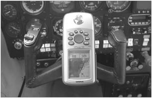
When we unpacked the GPS96C, we were struck by what seems to be an ideal size for use in an airplane.It comes with a robust, well-made yoke mount and the units are a perfect fit for the flight bag, briefcase, car and for the panel of a Boston Whaler. One of the biggest complaints we hear is that some portables are just too big to yoke mount but the 96s seem just right. With dimensions of 2.7 inches by 6.2 inches by 1.4 inches thick, the seven-ounce GPS96C feel like a largish cellphone.
But there’s a tradeoff. With a case size of these dimensions, don’t expect a big screen; its a relatively tiny 2.6 inches diagonal with a 256-color TFT display. But its 160 by 240-pixel resolution saves the day. While the on-screen characters are small, something that will be a problem for older pilots with marginal eyesight, we didnt find it objectionable once we adapted to it.
The backlighting is crisp and fine tuning of contrast allows the user to select a screen display that works best. Color blind? Select among almost a dozen different daytime and night-time color schemes including Amethyst, Aquamarine, Diamond, Emerald, Opal, Pearl, Peridot, Ruby, Sapphire and Topaz.
How about the four-level grayscale, 180 by 240 pixel monochrome display GPS96? we’ll stop right here and suggest that you spend the extra dollars for the color version. We believe that the gray display is a worthy purchase-its crisp and clear in most lighting-but compared to the color GPS96C, its bland, in our view.
On the other hand, one of our testers thought the mono screen was easier to read because of higher contrast in a bright cockpit. If youre worried about the color version washing out in direct sunlight, it doesnt. If anything, we found it more readable in bright sun.
We suspect that Garmin knows that the $200 difference between the color and mono units will snag some sales that might have been lost to the competition, but buyers will have noodle the details to decide if the color is worth the extra $200. To your typical GPS geek, gray means old school; color is in. But when the panel-mounted gear goes dark, any color will do for back-up purposes.
Lots of Punch
Inside the small, fully gasketed and waterproof high-impact plastic alloy case, the GPS96C has a powerful GPS engine and, get this, no need for either external power or antenna. The built-in antenna, called a Quad-helix, continuously tracks and allows the WAAS-enabled receiver to use up to 12 satellites. During our trials, this receiver worked flawlessly in the airplane, in the car and on the boat. It does have input ports for a remote antenna and for a power cable but we don’t see the need for them. Out-of-the-box initial lock-on occurred in about two minutes.
Battery life borders on the miraculous. Two AA batteries-yes, two-can drive the GPS96C for 40 hours. The monochrome GPS96 will last 25 hours on two AAs. Odd that the color display goes longer on batteries than the monochrome one, making us wonder if Garmin did that on purpose to tilt buyers toward the color. In keeping with modern computer protocol, the GPS96C has a USB port and a fair amount of internal data storage, up to 119 megabytes. Youll want that to download map detail from MapSource CD-ROMs for ground navigation. Marine BlueCharts and automotive MetroGuide high-detail mapping data are also options and are seamlessly loaded through the USB port. The monochrome GPS96 has less storage capability, with 23 MB of optional MapSource data. In short, if you want this portable for road and/or marine use, the GPS96C is clearly the better option.
The data is stored within navigators memory without the need for external data cards. A USB cable for uploads is standard with both units and Garmin Waypoint software is included for transferring waypoints and flightplans to your PC. If the unit will always live in the airplane, you can run it with ships power with a cable provided.
Menus, Size
We find that these units are comfortable to hold in one hand with an almost aerodynamic feel and you can easily operate the buttons and rocker keys with your thumb. Zoom In/Out buttons scale the moving map range, a familiar direct-to button commands direct waypoint navigation, the on/off power button serves double duty as backlight control, the quit button backs you out of menus and the last command and the page button cycles through the units pages, which you can organize in your order of preference. For example, if you want the map page to sequence after the satellite status page, you can program the unit to do that.
There are five main pages: satellite status page, position page, map page, HSI/pointer page and the active route page. The menu key is a familiar Garmin function and pressing it brings up intuitive on-screen menus pertinent to the page youre on. Pressing the menu button twice brings up the main menu for system settings, all categorized with well-labeled icons, as with Windows. We ventured on a hurried, last-minute trip with the GPS96C and found that the menus in the GPS96 series are so intuitive that we didnt need the pilot guide. And the main menu has abundant choices, too, proving that the GPS96 is packed with capabilities for aviation, marine and automotive applications.
A few that stand out are the hunt-and-fish menu, which accesses a table of time frames for the best hunting and fishing opportunities for any given location and date. The aircraft menu allows you to enter custom information about your airplane such as cruise speeds and fuel burn. The stopwatch section contains a full-featured timer system and the flights menu serves as a built-in logbook, automatically recording departure and arrival locations as we’ll as route of flight and flight time and date. Garmin has free logbook software called Flightbook and the GPS96 will download stored data to your computer via its USB port.
The Jeppesen aviation database combined with a U.S. database of obstacles and obstructions brings increased capabilities to the map display. Towers and high-rise buildings are depicted on the map and it will warn of potential impact if your route points you at one. Obstacles in the GPS96C are displayed in red and yellow and different shades of gray on the monochrome version. This is even more reason to spend the extra dollars on the color version, in our view. Its just easier to read the screen.
As you approach obstacles, theyre marked with an X symbol. Obstacles that are predicted to be within 100 feet of your flight path are marked in red or in dark gray on the GPS96. Those that are colored yellow (light gray in the GPS96) are more than 100 feet off your flight path but less than the elevation of the caution elevation field below your flight path -which is user selectable.
With the exception of GPS-derived flight instruments, the GPS96 series has about all you would want in a budget portable. A graphic HSI with steering cues, GPS-derived vertical nav functions and approach data lead the list of features that make the GPS96 feature-rich for aviation. When you press the direct-to key, you have the option of selecting from a drop down menu that has key words such as aviation, listing the facility name and location, field elevation, type of fuel offered, waypoint distance and bearing from current location and the main frequency of the control tower or Unicom, for example. Selecting the comm label lists all frequencies for a given waypoint, while runway gives detailed descriptions of runway layout, lengths, and lighting. Approach functions are handled with similar logic. If the airport has a published approach, the approach name, FAF and missed approach point are drawn on the screen for monitoring, just as with a panel mount MFD. You can select vectors-to-final for the approach or navigate direct to the FAF on your own for each approach. Localizer-like runway extensions help set-up for the numbers at any airport, increasing situational awareness during visual approaches to unfamiliar airports.