by Larry Anglisano
Weve come to realize that the days of being blown away by a new portable GPS model are gone, at least for now. We hate to say that weve seen it all, but clearly the standard has been set-largely by Garmin- by which all modern aviation portables should be measured.
While there’s still a lively replacement market for owners of older models wishing to upgrade, feeding-frenzy buying is rare in the aviation portable market. So whats left to sell? Mostly niche products that find some sales through either low price or some features. In such a saturated field, any new portable must cover some important bases if it stands a chance of survival.
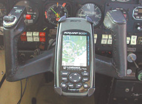
Itll need a bright display-color is an obvious preference-thats easy to read at a glance with or without sunglasses, easy and straightforward operating logic, a good fit for the control yoke and durability sufficient to live in the mean insides of a flightbag. And that, more than anything, seems to be the thinking behind Lowrances latest aviation portable offering, the $499 AirMap 600C. In the Lowrance tradition, it delivers an advanced featureset at an absolute bargain price.
Nice DisplayThe 600Cs display is what we wished for when we reviewed the lower-end AirMap 500 portable, but at its under-$400 street price, we couldnt complain. And there should be no complaints about the color screen on the 600C, either. Its a bright 2.83-inch diagonal TFT in 256 colors. Resolution totals 76,800 pixels, impressive specs for a budget portable. Backlighting is good, thanks to its white LED screen. Keep in mind that the 600C is a small unit, measuring 5.6 inches high by 2.5 inches wide by 1.2 inches deep and weighing 8.7 ounces. A color screen that measures just shy of 3 inches is a brilliant achievement on such a small chassis.
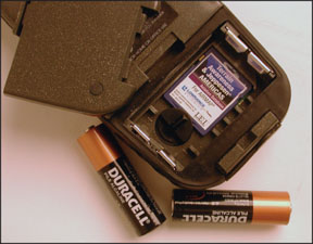
Power to the screen is provided by two AA batteries for 3 volts of DC input. Lowrance cautions that the provided cigar lighter power adapter has a stepdown converter for regulating the input voltage down to 3 volts, so if a custom, do-it-yourself hard-wire job is in order, don’t hack the plug off the adapter and connect the bare wires to the ship bus. If you do, you’ll send 12 volts flowing into the 600C, soon to be followed by smoke signals.
Still, as with any of these color portables, ships power is the way to go for full screen brightness, so we suggest plugging it in to the aircraft. Two AAs have a 12-hour endurance, says Lowrance, not nearly as good as the Garmin 96C, but more than enough endurance to get you back on safe ground in an emergency or for use in the car.
Performance, ErgonomicsBased on price, physical size and display type, the 600C is, in our view, a competitor to the Garmin GPSMAP 96C (street-priced at $699). When the 600C arrived, we unpacked it and set it up in the usual know-it-all manner. Never mind the instruction manual. As we loaded in the batteries, we initially thought the unit had an insubstantial case-well stop short of calling it cheap, but it doesnt compare favorably to a Garmin GPSMAP 96 or anything Garmin makes.
Garmin sets the standard in portable unit ergonomics, in our view, so any other brand has big shoes to fill. We fought with the battery compartment, unable to secure the cover and we thought we had broken it. We eventually got it to stay shut after reloading the batteries a few times. In the bottom of the battery case lives the 512MB storage card that contains Lowrances exclusive terrain awareness, obstruction data and what Lowrance calls Safe Flight 21, which is airport taxiway mapping data. Jeppesens Americas database includes airports, VORs, NDBs, intersections and approach control and FSS frequencies.
For initial lock-on, we placed the unit on our standard satellite acquisition test range: the edge of our back deck nestled in dense woods. By the time we stepped inside to fetch a cold one, the unit was locked on and ready in less than a minute. This is impressive and so is the 600Cs GPS engine, a 16-parallel channel GPS/WAAS with internal antenna. A remote active antenna is standard equipment. We found that the unit locked inside a building, inside a vehicle and inside an airplane cabin without a remote antenna attached to it. It only takes three satellites to obtain a 2D fix position without GPS altitude, so these lock-on habits arent unusual for a modern portable. But we think that the 600Cs GPS performance is exceptional, perhaps better than any unit weve tested to date.
The 600Cs keypad, like many of its features, is identical to that of the lower cost AirMap 500. To recap, the PWR/LIGHT serves double duty for on/off and commanding the display backlighting. However, we struggled with turning the backlight back on after it timed out. The power button is recessed into the plastic case to avoid inadvertently powering off, so its awkward to get at it. You could, of course, set backlighting on constantly, but that would eat up batteries in no time.
The PAGES button simplifies aviation operating modes such as position status, navigation and map page. MENU pulls up a menu for each page displayed.
A center rocker pad with arrow nomenclature is used for moving around menus while the Lowrance trademark ZOUT/ZIN is for map zooming in and out all the way to 4000 miles.
The ENTER/SAVE executes menu commands and saves waypoints. EXIT will back out of menus, clear data or return to a previously viewed screen. A main menu is accessed from any page simply by pressing the MENU key twice where a variety of system settings and options can be accessed.
324
Overall, the operating logic of the 600C is straight-forward. We suspect based on feedback from others unfamiliar with Lowrance software-owners of Garmin portables, chiefly-some will have brief difficulty with the Lowrance operating logic, since commands are handled differently. With a little effort, this hurdle can be cleared.
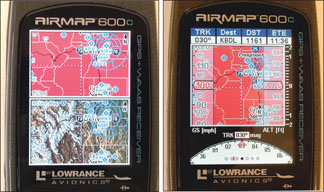
Terrain FocusThe 600C is similar in features to the AirMap 500, but we found some new ones, too, that are impressive and useful. The color screen is put to good use in the 600C through enhanced topographical terrain and obstacle mapping as we’ll as enhanced navigation and situational awareness. Lowrance does a good job of keeping major operating modes simple and there are three major modes: satellite page, navigation page and map page.
Navigation has three display options: aviation map, HSI map and navigational airspace. The map page has five options including map panel, full map, compass overlay, position, and two maps. When enabled within the map category, color contoured terrain awareness features are drawn on all the map displays, depicting the height of surrounding terrain.
The 600C notes the current GPS altitude in relation to the elevation of the terrain below the aircraft and displays standard and familiar terrain color coding. For example, a red highlight warns of terrain at your current altitude, yellow indicating that terrain is 500 feet below and green indicating that the terrain is 1000 feet below your GPS altitude. The terrain color contouring on the 600C color screen is a nice touch, in our view, and in an avion ics world where terrain warning is standard stuff, we wouldnt expect anything less.
On the topic of terrain color shading, the 600C has a navigation airspace option, where two windows on a single page are depicted onscreen. The top window (called map window) shows a map with terrain and Jeppesen data overlaid for enhanced navigation. The bottom window (called profile window) shows the aircraft altitude relative to a 2D cross-section of the terrain ahead. Airspace altitudes are also depicted in this window.
Obstacles and terrain are both depicted and in standard profile format, the aircraft is on the left side of the screen with terrain and obstacles to the right. In level flight, the “altitude line” is parallel to the ground while in a climb but swings down in a descent. The point is that the 600C offers terrain, obstacle and airspace alerting in a format not even found on some panel mounted MFDs. If you bust altitude or airspace with the 600C, its your own fault.
Mini-EFISOur favorite feature of the 600C is the HSI Map function that partially mimics the look of a glass cockpit instrument panel display. We liked this function when we flew with the bigger 1000 and 2000 series Lowrance products and we like it equally on the 600C. The map panel page is the 600Cs best display
For situational awareness, depicting a moving map in the center with a GPS altitude window on the right, with vertical speed to the right of that, and groundspeed to the left.
What makes this view glass-cockpit-like is the tape trend format, just like on a real PFD. Just remember that this isn’t actual indicated airspeed and altitude, but instead GPS-derived groundspeed and altitude. We think that having all of this data on a single screen is impressive.
Another feature we like is the compass overlay display page. On this screen, a track compass rose is superimposed on a navigational map with a bearing pointer indicating the course to the destination waypoint and a CDI displaying on-course status. Data fields depicting speed, distance, bearing and so forth are displayed at the top of the page and can be customized accordingly.
The no-nonsense full map page is useful, too, and works we’ll in the car and on the trails, especially with additional high-detail MapCreate USA ground and hunting data overlaid. This data comes standard with the 600C. We loaded the entire country of topo maps (six disks) on our PC and it took more than an hour running Windows XP. Its a lot of data.
In the dual or two-map mode, your current position is depicted on the map at the top portion of the screen while the bottom portion can depict an auto-zoomed view of the destination airport and its runway layout. You can zoom each map for a better picture of whats happening or about to happen, which helps immensely in orientating your approach to an unfamiliar airport.
Initially, we didnt find this feature intuitive. We could scale the bottom map, but not the top one, which was set in a scale depicting the entire country. Switching the active map requires a dual press of the PAGES button and without reading the manual, we were lost. Our bad for not hitting the books, which also explain that the size of these maps can be adjusted and orientated to your liking, thus taking glass-cockpit functionality to a higher level.
As weve noted with previous Lowrance models, the OBS hold is a helpful feature for maneuvering off- course to avoid weather and traffic, where you can select a radial to fly to or from a location. Using arrow keys once the feature has been activated, you can plot a course line different than that of your destination course line and then cancel the OBS hold to get back on your desired course.
If at any time you want to see airspace information when in motion, the airspace status command will tell you. Press the MENU and ENTER keys and up comes specific text about the airspace and time remaining for staying in it. These kinds of enroute navigation features could be handy on every panel-mounted system and its interesting to see it on a budget portable and not on most panel mounts.
Further, when its time to land, the 600C shows you everything it knows about the runways at the destination airport through the runways screen. This isn’t new in a portable, but whats unique is the runway extend feature. It draws extended centerlines with an option for runway approach guidance, a localizer-like course guidance to join up on the visual for landing.
ConclusionWe have to give the Garmin GPSMAP 96 series a slight edge over the 600C simply for perceived ruggedness, if the mission is all-purpose navigation. The AirMap 600C wins hands-down in aeronautical featureset, however. The 600C, while marketed for air, land and marine use, seems better suited for remaining on the aircraft yoke.
We found the 600C to be a capable land navigator, too, but we were afraid we might break it over the long term, since land-use portables get beat up in the car. When we consider that the unit comes complete- Buy and Fly, Lowrance calls it-with a hardy yoke mount, power cable, MapCreate USA topo software, MMC/SD card reader and writer, remote amplifying antenna and soft carry bag as we’ll as the advanced functionality weve described here, its street price of $499 makes it an absolute top-value winner in a crowded portable field.
Contact – Lowrance Avionics, 800-324-1356, www.lowrance.com/.
-Larry Anglisano is Aviation Consumers avionics editor. He works at Exxel Avionics in Hartford, Connecticut.