by Larry Anglisano
Following a flurry of market activity in 1999 with its AirMap 100, Lowrance Avionics put itself on the map as a competitor-really the only competitor-for Garmin. Then the market matured and Lowrance went quiet in the aviation field. Last fall, the company got busy again with two new portable GPS navigators, the AirMap 500 and the larger-format AirMap 1000.
In the AirMap 1000, Lowrance is offering a flagship aviation product aimed to set the standard for modern back-up navigation. Portable GPS navigators used to be exciting but with the recent advances in panel-mount technology, many pilots view a portable as cheap insurance in the event of primary system failure. Garmins 196 upped the ante by offering a GPS-driven flight display panel that did we’ll in our tests of gyro back-up devices.
As we reported in the November, 2003 issue of Aviation Consumer, Lowrance has kept pace with the competition with the bargain-priced AirMap 500 portable and although we arent complaining, the 500 lacks the must-have flight instrument functions of the Garmin 196. (At $499 retail, the AirMap 500 offers plenty of value, despite the lack of the flight display.) Think of the AirMap 1000 as picking up where the 500 left off, with quicker operating speed, a larger, brighter display and more features that offer convenience and utility. During our AirMap 500 review, Lowrance sales manager and airline captain Larry Toering graciously promised us the opportunity to play with one of the first AirMap 1000s and he delivered as promised. Herewith are our findings.
Big Unit, Big Screen
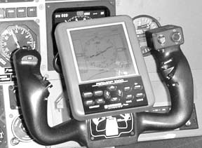
The AirMap 1000 is large enough to be mistaken for, at first glance, for a small EFB-(electronic flight bag) type tablet computer. The case size is ruggedly designed at 6.25 by 4.9 by 2.5 inches, is water resistant and weighs 1.2 pounds with four AA batteries installed.
Advertised battery life is 15 hours for normal operation. The 5-inch diagonal high contrast film supertwist LCD display is sharp and easy to view in most lighting conditions that we tested under, although we had to boost the display brightness to almost full gain and then boost the contrast to darken the text characters. Resolution is crisp, even when viewed from behind polarized Ray Bans. With a total of 102,400 screen pixels, the user-controllable white backlighting provides a nice view. The function keys light for night ops and this is an important touch that some portables have omitted. The 1000 has a GPS/WAAS-enabled 12-channel engine with integral antenna and is equipped with an active external antenna. As we noted with the AirMap 500, we wish the antenna coax was heavier instead of the spaghetti-thin RG174/U cable.
For a unit as hefty as the AirMap 1000, this cable seems out of place, although the RF connector input port for the antenna is nicely protected within a recessed inlet in the back of the case, a redeeming feature because the cable and hardware take a beating in the harsh cockpit environment. Heck, just pulling the unit out and tossing it back into the flight bag is abuse.
The function buttons, which are made from a rugged, rubbery material, have a positive feel and are borrowed from the AirMap 500 design. The AA batteries load through a compartment in the back of the unit, which also houses the 32MB multi-media storage card. Its the same 32MB card used in the AirMap 500. (Note: in the AirMap 500 review, we mistakenly reported that the standard card is 16MB.)
The storage card is used for accessing Jeppesen and obstruction databases as we’ll as navigation files such as flightplan data and high-detail mapping data derived from the MapCreate mapping software supplied as a standard accessory with the unit.
Also supplied standard with the AirMap 1000 is a yoke mount bracket assembly manufactured by RAM, a cigar-power interface cable, batteries, the remote antenna/suction mount and RF cable, an MMC/SD card reader/writer and a cloth storage bag. Lowrance calls this kit Buy and Fly, which makes the AirMap 1000 a complete package, with no other accessories required.
Controls
The bottom portion of the case houses the function buttons including the power/light key for setting screen lighting. The pages key, along with arrow function keys, toggles the system between three page screens: satellite, map and navigation. These pages are the major modes of operation and the menu button calls the onscreen menu for further functionality.
An enter/save button executes commands and saves data throughout all modes of system operation while an exit key backs you out of menus and clears previously entered data. As with the AirMap 500, we sometimes had a tendency to use the enter key instead of the exit key for some functions.
We were quickly reminded that Garmin operating mentality wont work with a Lowrance product. And vice versa. The now-familiar Lowrance ZIN and ZOUT keys are for zooming map operations and these still make us chuckle, in Pig Latin.
On every start-up, two messages appear on screen: A death-and-destruction warning about responsible navigation plus a reminder from Jeppesen that they and only they rule the world of navigational data. This is one of those instances where we continuously pound on the ENT key but only the EXIT key makes these messages disappear.
Pressing the menu button twice calls up a single main menu for commanding screen set-up, sounds and alarms, route planning, GPS set-up, a full array of aviation nav computers, including E6B functions, plus other system set-up parameters.
You also get count-up and count-down timers and an alarm clock, plus trip computers for average speeds and other trip statistics. The main menu commands data and files that are stored on the MMC card. A find key with the familiar direct-to nomenclature does just that; commands direct-to waypoints and points of interest.
Performance, Pages
Three major pages make up three operational modes on the AirMap 1000. The available space on our pages doesnt allow us to detail every key stroke of this unit and we wont try. Here are some highlights: The satellite status page provides detailed GPS engine/lock-on integrity status.
A graphical overview of the satellites that are currently in view is shown on the top of this status page and a familiar circle that represents the earth shows each individual satellite currently in view. This is helpful to see if the tail of the aircraft is shadowing any satellites and offers proof that the external antenna should be used for aircraft ops, especially in high-wing aircraft.
While on the subject of lock-on and GPS engine performance, the 12-channel receiver in the AirMap 1000 proved reliable during our testing in the air and on the ground. We experienced a severe deep freeze during much of our testing, with air temperatures ranging in the single digits for highs to we’ll below zero for lows. While not appealing test conditions for the human doing the testing, it was interesting to see how the AirMap 1000 operated in such a hostile environment.
While we couldnt find any environmental operating range data in the specifications, the display wouldnt come up after sitting in the frozen cockpit overnight. The unit turned on; we could hear its beeping, but the screen was blank. To be fair, the test unit sat for at least eight hours at minus 10 degrees Fahrenheit. We wouldnt expect many users to operate the 1000 in these temperatures but forewarned is forearmed. Once warmed up, the display was fine.
On the satellite status page is a signal strength meter for each satellite in view, a position error box with numeric values of accuracy-the smaller the value, the better the performance. Seven other data fields on the left side of the screen can be customized to show current nav data and other helpful information, such as a voltage monitor, date, time and so on.
The navigation page has its own menu and this is where the unit boldly goes where few other portable units have. The navigation panel is the AirMap 1000s claim to fame as it not only mimics flight instrumentation but shows these instruments in PFD (primary flight display) format. Complete with speed (groundspeed) and altitude-trend tape display with vertical speed data, the unit gives us poor folk a taste of the recent PFD and glass cockpit developments. However, it has no bank-angle reference and thus isn’t quite up to the standard of Garmins 196.
Having this data in color would be nice and we half expected this unit to be color. Alas, its not. Still, the display isn’t bad and is clearly a step above the AirMap 500s display. Like the Garmin 196-also a monochrome unit-these instruments can be used to help you out of trouble in the event of a vacuum failure, as long as you have good satellite coverage, since the flight data is GPS derived.
What we found most interesting was that the GPS-derived vertical speed data matched the static system VSI in our test aircraft. When the mechanical VSI on the panel indicated a 2000 FPM climb, so did the AirMaps VSI. Impressive.
In the center of the page is a compass rose with HSI display. When you arent navigating to a specific waypoint or destination, the display is basically an electronic directional gyro with an arrow pointing down at the top of the compass rose to indicate the current track over the ground. Plug in a waypoint and up comes the HSI presentation with a numeric course value, cross track error scale, CDI, course arrow, TO/FROM flag and bearing arrow that points to the waypoint.
At the top of the page are data fields that can be customized to display distance, waypoint identifier, bearing and so forth. At the bottom of the display is an enlarged compass overlay. Initially, this seemed a bit strange and almost too busy-an arc view of a compass rose shown below the HSI. But the feature allows you to graphically and numerically display both course and magnetic track data. In any case, the glass cockpit-like nav display is fresh and cutting edge, even if it doesnt provide a wealth of critical flight data.
Just like the AirMap 500, the 1000 has OBS hold for navigating along an imaginary radial when going to or from a selected waypoint. Simply put, if you need to deviate off course to avoid weather, hot prohibited airspace or to fly radar vectors, you can select OBS hold until you get back on course and then resume normal navigation.
The left and right arrow keys allow you to increase or decrease your deviation angle relative to your intended temporary change off course, all through the help of a pop-up window that prompts you throughout the hold procedure. At first, this creates a bit of head-down time when you should be looking outside or keeping your scan going, but with practice, it becomes intuitive.
The map page has lots of user- selectable presentations and offers detailed information about the airspace youre in with the airspace status command. A map display of some kind is available on several different pages and the user has the option of showing split-screen navigation/map data or full-page map data.
The aircraft on the lower portion of the map identifies present position and points in the direction that youre heading and you can turn a slug trail on or off to plot the path that has been traveled.
If the airplane suddenly turns into a flashing question mark, youre on your own as this means that position data has been lost or not yet calculated. Map data can be zoomed from .02 to 4000 miles for a total of 39 range settings. Zoom scale distance is represented from one end of the map to the other. Five data fields at the bottom of the map can be customized or you can simply turn off the fields for a full-page map display.
Yet another option allows a compass overlay over the map. This page is a map display with a portion of a compass rose displayed at the top and includes a bearing arrow that points toward the destination. Track or heading value can be shown in a window at the top of the display. Floating compass overlay data such as bearing, distance, ETE, ground speed and the like can be customized and shown at the top of this page. Its clear that users of the AirMap 1000 have impressive flexibility when it comes to moving map and navigation data and mixing combinations of the two.
Approach Help
Our favorite mapping feature is the dual map presentation. This allows you to see your current position on one side of the screen and a zoomed-in view of the destination airport on the other side.