
by Larry Anglisano
While Garmin has dominated the portable GPS market with innovative products for the past decade, its current sole serious competition-Lowrance Avionics-is hardly a one-hit wonder. Lowrances presence in the portable aviation market dates back to the mid-1990s and its first aviation product, the AirMap, gave Garmin a run for the money in 1996 and spurred the Garmin 195 in response.
Lowrance has maintained a presence in the aviation, marine and recreational GPS market and its newest aviation product, the Airmap 500 portable, offers buyers some utility in all three segments. In keeping with past tradition, the Airmap 500 comes complete with everything you’ll need without having to purchase any accessories, a real plus in simplifying the purchase process.
The Airmap 500 is actually one of two new products from Lowrance. The other is the Airmap 1000, which appeared at Oshkosh. But it wont be ready for a few months, at least. In the meantime, you can buy a fully equipped Airmap 500 for $499, a bargain price considering the accessories and capabilities.
Read the Instructions?
Of course not. At least not until the navigator does something baffling. One of the things that has always impressed us with the Garmin line of portable units is the fact that we could operate one without consulting the owners manual. In our view, this is the acid test of how successful the designers and software writers were in creating an operator friendly gadget. When your butt gets thrown into the ringer and youre faced with an electrical or instrument failure, you want a portable thats not difficult to operate.
So we turned on the Airmap 500 without consulting the manual and although we could make the unit perform basic tasks, we wouldnt want to add the workload of single-pilot ops without first gaining some experience with it. Having said that, the manual shipped with the 500 is the best weve seen in quite some time. Its written for idiots and generous use of photos supplements the text instruction. Further, on-screen help is available for most of the 500s menu items. For example, if you highlight a menu item and leave it highlighted for more than few seconds, you’ll see a pop-up message describing the functions of that menu item. Very handy.
The Airmap 500 is cutting-edge with a 12 parallel-channel GPS WAAS receiver. The unit comes standard with an active external antenna for mounting on the windscreen. We wish that the antenna cable between unit and antenna was the thicker, heavier coaxial cable. While providing the thinner RG174/U cable is we’ll intentioned, heavier RG58 coaxial cable with BNC connectors is simply more rugged in a portable environment.
Since the receiver is 12 channels, you can expect decent satellite lock without the external antenna but there were times during use in our vehicle where the external antenna was necessary.
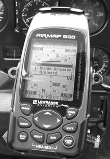
The unit is quite small and very small compared to most Garmin aviation portables. The case size of the Airmap 500 is 5.6 inches high by 2.5 inches wide by a mere 9/10th-inch deep.
It weighs only 7.6 ounces with two AA batteries. These batteries will last about 12 hours in normal operating mode (one-second position updates) and the standard cigar lighter power adapter will make it run forever without batteries.
No color in the 500s 3-inch diagonal display but a high-contrast film super-twist with LED backlighting. It did we’ll for us in all lighting conditions but it seems a tad behind the times not being color. We had a little trouble reading the display in direct sunlight, but only occasionally.
As for mounting, the 500 comes standard with an excellent yoke mount which worked we’ll in the Cessna, Piper and Mooney we used in testing the GPS. If you use it in a car-which we did-mounting is more difficult. For marine use, the 500 is water resistant, according to Lowrance.
Three In One
A worldwide base map is stored in the unit and includes rivers, cities, major lakes and political boundaries. U.S. map data is more detailed and includes interstates and highways, including exit and services information, as we’ll as lakes and streams. A standard and familiar Jeppesen Americas database including airports, VORs, NDBs, intersections and airspace data is also included.
We were impressed with the Lowrance obstructions database, which displays ground obstructions in either AGL or MSL heights. This is a refreshing feature in a handheld GPS. If you need detailed map data-for navigating on the ground-this unit will accept, via MMC or multi-media storage cards, custom map data through the MapCreate program. Its loaded on up to 256MB storage cards and then inserted into a slot in the battery compartment. you’ll need to remove the batteries when you want to replace the storage card, since it lives behind the batteries.
The yoke mount and power adapter are rugged and connecting up in the airplane is easy. The display view was decent and fine-tuning the yoke mount tilt kept the unit we’ll out of the way. The Airmaps small footprint makes it the perfect size for yoke mounting, something that cant be said of all portable GPS.
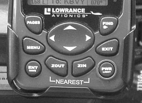
The buttons on the face of the 500 have a positive feel and are made of a rubber-like material. The power button serves double duty as a backlighting control. The exit key backs you out of menus and also acknowledges messages, although our natural tendency was to acknowledge the messages with the enter key. But this isn’t the way it works. The page key switches the unit between five different screens while in aviation mode: satellite, present position, electronic HSI, map page and airport orientation. The menu button brings up the menu for each page, from there you can then select submenus using the up, down, left and right arrow keys to move around the menu.
The enter key executes menu commands and is also used for saving data, say for saving a personal waypoint, for example. The find button-also labeled with the familiar D abbreviation for direct-to-calls up search menus where you can select search lists depending on where or what you want to go to. ZOUT and ZIN arent strange Latin abbreviations but zoom in or zoom out keys while on the map page.
The main menu on some handhelds can be overwhelming but we found the Airmap 500s main menu to be straightforward. We couldnt figure out what the songs option accomplished until the off-course alarm was triggered and the unit played a song and dance to alert us. Amusing.
A utilities submenu on the main menu brings you into aeronautical calculators, including an E6B for true airspeed, unknown winds and such. The browse MMC files function is used to identify the data youve stored on the MMC land data card, if installed.
Panel Mount Features
The 500s basic navigation and map features are routine, as with most aviation handhelds, but there are a few features that stand out. First, on the HSI page, there’s a crosstrack error range figure which puts a numeric value on the familiar crosstrack error scale of the D-Bar. The crosstrack error-and direction of the error labeled with an R or L -is shown in a text box on the bottom of the HSI page. Default crosstrack error range is 2 nautical miles and is verified by a floating text box underneath the error scale. With these graphics, there should never be any confusion or question of how to get back on desired course. And with the cute off-course song singing you the blues, you shouldnt wander far.
This unit also has an OBS-hold feature to help with navigation duties that might deviate from your flight plan. For example, if you navigate from VOR to VOR, you can set OBS hold and fly an outbound radial from the VOR. This feature is clever for enroute deviations around a TFR or flying common ATC instructions that take you temporarily off course for traffic and weather avoidance. OBS hold can only be activated and deactivated from the HSI page, which makes sense.
Its easy to load a portable GPS with too much information. While the Airmap 500 indeed has a lot of information packed into its many menus, accessing important stuff isn’t difficult and the pop-up help messages lend a hand. Two of the most important pieces of data for handhelds, in our view, are the airport information page and the airspace status page.
The airport information screen shows runway layout, length and width, lighting data, elevation, frequencies and an extend option. Commanding the extend option gives extended centerline data for any runway in the database, provided there’s enough published data to support the extend information.

These runway extensions are meant to serve as visual cues to help maneuver the airplane for landing. How many times have you made a tight turn on to final at an unfamiliar airport and found yourself blowing through the course with little time to correct or even lining up for the wrong runway on a hazy day? Using the extend feature gives a visual map cue for judging a visual approach.
For airspace data, the airspace status command will provide information for airspace contained in the database. While enroute, pressing the menu and then enter buttons calls up this screen. Time till and distance till the airspace is shown, as we’ll as ceiling and floor MSL heights of the airspace.
Appropriate frequency information is also given. This is straightforward and more useful than just plain old airspace ring markings on a map. If you use this feature, there’s no excuse to bust airspace altitudes.
Once you get to your airport destination, the services command is helpful for ground service data such as the availability of maintenance, types of fuel, airport lighting and so on.
Most portable and panel- mount GPS these days has vertical descent profile information so there’s no need to do the ballpark math to figure out when to start downhill for landing. With the Airmap 500s vertical navigation calculator, you enter your descent data and the system figures out how-based on the active destination waypoint-where and when to start your descent.
For example, if youre flying level at 4500 feet and you need to be at a traffic pattern altitude of 2300 feet when 5 miles out, the unit will do the calculations and give you an exact time to start your descent based on your chosen FPM rate of descent. The only drawback we see is the number of keystrokes it took to find the darned vertical nav calculator. Its buried in the utilities menu. Once you know where to find it, you can make good use of it and your passengers ears will appreciate it.
We wont cover much detail here on the land mode, a topic for a different comparison. But the land mode on the Airmap 500 seems logical, although a color display would enhance its appeal and function. Were not sure the relatively small display of the Airmap 500 is we’ll suited for everyday navigation in a vehicle but the MapCreate custom mapping software has tons of cartographic data to load on the standard but small 16MB MMC storage card.
If you use your airplane for business travel, this unit is we’ll suited for taking along in a rental car once you park the airplane on the ramp. The 500 we were provided came loaded with road data for Connecticut and surrounding areas and from our trials in the car, we cant see how you could get lost. Menu hopping in land mode is similar to that of air mode operation so finding the local pizza joint or state park is straightforward. Its also easy to move the on-screen cursor over a highway exit and you can quickly see all of the services offered on that exit. No restrooms? Find a tree.
Conclusion
The Airmap 500 is impressively compact and its 12-channel WAAS enabled receiver is a good performer. But at this stage in GPS technology, there’s no excuse for poor performance. We wish that this unit had a color display but its tough for us to complain, considering the cost. Not that the display is bad, its just boring compared to the color units weve gotten accustomed to. (Okay, we’ll admit it; were spoiled brats.)
We think the outstanding thing about the Airmap 500 is the price. It packs a heavy punch in a small package for only $499. The nearest competitor of similar or greater capability is the Garmin 196, which sells for about the mid- $900s discounted. We don’t have any reservation in saying that the Airmap 500 represents the best current value in an inexpensive GPS and may best the 196 in overall value if not capability.
We especially like the 500s airspace functions and the customizable HSI navigation page with its OBS hold function. Very sophisticated stuff. For a list price of $499, you get a WAAS-enabled GPS, an external antenna, yoke mount, power adapter, MapCreate software with CDs for U. S. east and west coasts, with a 16MB data storage card, plus a USB PC interface reader. A heck of a deal.
GPS-derived flight instruments, as Garmin has in the 196, would seal the deal for many buyers. But at this price, we hardly think it fair to expect that kind of capability. If youre looking for well-rounded, WAAS-enabled handheld GPS that can serve double duty as a land navigator, we cant see any reason why you wouldnt be happy with the Airmap 500, especially considering its price.
Also With This Article
Click here to view “Checklist.”
Click here to view “Roll Your Own GPS.”
Contact Lowrance on the Web at www.lowrance.com or 800-324-1356 to locate a dealer.
-Larry Anglisano is The Aviation Consumers avionics editor and quickly gets lost in the air and on the ground if not for portable GPS.
