by Larry Anglisano
In a crowded market dominated by good performing portable GPS navigators, the $1000 question remains: Which model is the best value for the money?Having tested them all exhaustively, we conclude that there’s no easy, one-size-fits-all answer. The market has matured and all of the current offerings are competent, with few warts.
Because even the most basic portables aid in situational awareness and increase safety, investing in any of the units covered in this article will be worth the asking price, whether you fly behind a glass cockpit or behind start-of-the-art steam gauges. In this report, we’ll compare the pros and cons of the various portables based on our own trials and from user feedback.The make-or-break buying decision will come down to how much weight you place on factors such as screen clarity, overall size and mounting scheme, battery life and flexibility for land and marine use. Bottom line price ultimately decides the rest.
GPSMAP 96/GPSMAP96C
Were surprised that the budget 96 series hasnt generated the buzz that other models in the Garmin lineup have enjoyed. We suspect that the market was just too crowded when the 96s were introduced and while the color GPSMAP96C and monochrome GPSMAP96 are capable, theyre not sexy enough to overshadow the flagship models in the Garmin line, the GPS196 and GPS296.
At first blush, the choice between GPS96C and GPS96 is confusing. One has a color screen with lots of internal memory and the other has a monochrome screen with less memory. (The memory is for land and marine data storage and wont affect aviation mode.) Interestingly, the color version has better battery endurance. Two AAs can power the color 96C for up to 40 hours while the monochrome 96 will run 25 hours, which is still impressive. There’s a $200 cost Delta between the color and monochrome models-$699 and $499-and, in our view, the color GPSMAP96C is we’ll worth the extra cost.
While the gray-scale monochrome GPSMAP96 is hardly a poor read with 180 X 240 pixels, the 256-color GPSMAP96C is brighter and easier to see in all lighting conditions. But both versions have relatively small on-screen characters, although the color screen can be customized to improve this.Color blind? Change the day and night color schemes to something like Topaz, Pearl, Sapphire, Ruby or a handful of other artsy backgrounds.
Both units have Garmins solid 12-channel, WAAS-enabled, GPS engine that performs flawlessly, even when running solely with the built-in antenna. The units have a port for plugging in a remote patch antenna but its hardly needed. We recently used a GPSMAP96C in a small jet and it never missed a beat, remaining locked on through the heated windshield.
Last, either unit is the ideal size for any use or for those who just don’t want a brick-like portable cluttering up the cockpit. Whether yoke mounted, on the car seat or stuffed into a flight bag, the 96 series never gets in the way and offers excellent performance at a price that fits most budgets.
GPSMAP196
When the monochrome-display GPSMAP196 appeared three years ago, consumers were amazed that a portable could mimic flight instruments, making a no-gyro situation a non-event. Sure, the 196 is dull monochrome, but during a gyro failure, we don’t need no stinkin color, thanks. And, at a price point just shy of a $1000-what we define as the mid-range in aviation portables -the 196 remains a good bargain and thus far has been a popular seller for Garmin.
Since the advent of the glass cockpit, overall confidence in steam gauges is in decline and the GPS196 remains a low-cost modern back-up for a six-pack panel. Derived from the marine line of portables (the GPSMAP176), the 196 is compact but not as trim as the 96 series. Still, at 5 1/2 X 3 1/4 X 2 inches thick, the 15-ounce 196 makes for a comfortable fit on the yoke.
The 12-level grayscale LCD display is larger than the screen on the 96s and we found it reasonable to view at most angles, although with polarized sunglasses we struggled in some lighting conditions. The GPSMAP196 is one of the first fast-processor units from Garmin, running at about 70 MHz. That means quick map redraws and faster operating speed through menu and screen changes. Previous Garmin portables were slower and users have commented that the 196 is vastly faster than the older GPS195/295 units, which have been discontinued. On top of the GPS-derived flight instrumentation (track, HSI, groundspeed, GPS altitude, VSI and turn indicator) that got us to the runway without reference to the aircraft instruments, the 196 has approach procedures in its database, a plus for a portable used for back-up. GPS performance is trademark Garmin reliable and we applaud the beefy antenna cable and durable BNC connector for the remote antenna.
For use in land mode, the 196 runs the optional Garmin City Select mapping product with the data burned onto a flash card and inserted into the unit.We would prefer internal memory storage for this data, as with the GPS96 series, but we like the 196 for kicking it up a notch for road use compared to older units.
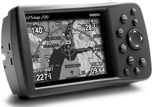
GPSMAP296
The GPSMAP 296 is Garmins top-of-the-line navigator, with a price to match. (Discounted retail, about $1800.) Sporting features and similar physical dimensions to the 196, the 296 is often looked upon as an upgraded 196 that has an expensive 256-color screen.
Not really. The 296 has a 200 MHz fast processor, a sharper and brighter display and an extensive, TAWS-like terrain database. In our view, the GPSMAP296 stops just shy of duplicating an expensive panel mount system. Owners rave about these things.
With my 296, I don’t need a GNS530 or other expensive panel-mounted units. I have interactive terrain, flight instruments, approach procedures and a sharp color screen, says one panel-space-deprived Mooney Ranger owner who wrote us. This is not what FAA wants to hear about portables but the fact is, the GPSMAP296 boldly goes where other portables don’t, with the sacred terrain alerting and flight instruments. As we noted in our review, this terrain mapping isn’t a TAWS substitute, but it has enough data to keep your unsuspecting hide out of the hills and towers. Everything you need is standard with the 296, including yoke mount, portable battery charger to charge the 15-hour internal Lithium-ion battery -we saw six hours out of a full charge, not impressive-ships power cord and USB cable for uploads.
Terrain mapping and alerting follows TAWS logic and the rich screen colors represent terrain based on elevation. A full display is dedicated to terrain depiction, clearly indicating where you are relative to terrain. In road mode, the 296 shines, providing turn-by-turn directions in multiple languages through a speaker built in to the power cable.
The latest Garmin portables have a power/data interface, in which the unit has a direct RS-232 link to a Garmin panel-mounted GPS. When a waypoint and flight plan is entered into a GNS430, for example, the data is streamed to the portable for redundant overlay.
Lowrance AIRMAP500
The Airmap500 marked Lowrance Avionics quest to go after Garmins lead in the portable market. At a price of under $500, the Airmap500 gives lower-end Garmin portables a run for their money, in our view. The 500 comes as a complete package; buyers need no additional accessories. Its intuitive, too, and novice pilots who buy the unit for help in navigating their first cross-country trips should do fine with it. It even has on-screen help prompts in case you get stuck.
Performance from the 3-inch diagonal monochrome screen is reasonable, for a low-end portable, and the LED backlighting helps in most lighting conditions. Compared to others, the display is utilitarian but easy to live with, just the same. Battery life is good; two AAs keep it perking for every bit of 12 hours. The 12-channel WAAS receiver performs we’ll and WAAS in a low-end navigator is a surprising plus.
Still, the featureset of the Airmap500 is far from low end, with functions youd expect in portables with a fatter price tag. For example, the OBS hold feature temporarily stops the units navigation while you maneuver off-course to avoid weather or airspace. And speaking of airspace, the unit has an intuitive and comprehensive airspace alert function that gives detailed time and distance until penetration of all airspace within the database, blowing a hole in any excuse that you didnt know the airspace was there.
The vertical navigation function precisely puts you at traffic pattern altitude, but not before advising you when to descend based on your position relative to your destination. You choose your descent rate and the unit does the rest. It will even put you on an extended runway centerline for landing, a powerful tool to shoot the visual precisely at unfamiliar airports.
Basic navigation functions are plentiful, too with electronic HSI with crosstrack error and a D-Bar presentation thats customizable. Road navigation is through MapCreate mapping software loaded onto a MMC storage card. We found the 500 to be a bit awkward to keep steady in the car, but the land data presentation is straightforward enough to get you where youre going without getting lost.
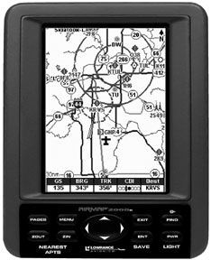
Airmap1000/Airmap2000C
The Airmap1000 model picks up where the 500 leaves off, and offers a larger and crisp screen and a heftier chassis that measures a 6.25 X 4.9 X 2.5 inches and weighs 1.2 pounds with four AA batteries. At $799, it represents a good value for such a large screen display. The 1000 has the same airspace alerting and runway centerline extensions that we like in the 500. But the 1000s most impressive trick is found on the navigation page, which mimics a PFD, including a detailed arc-compass presentation, GPS-derived vertical speed presentation and groundspeed displayed in trend format. While the Garmin GPSMAP196 and 296 models play flight instruments in steam-gauge format, Lowrance shows similar instruments in modern PFD style.
Its not really all of the flight instrument data youd see on a PFD, or in the Garmin, for that matter but the display presents useful information all the same. As noted in our review, the 1000 has a complete accessory package that comes with the basic unit at reasonable price point, even without considering high-volume mail order discount.
The Lowrance flagship Airmap2000C is the ritzy color version, a feature that comes at a premium. Still, at about $1000, its cheaper than Garmins 296. On the other hand, the 2000C doesnt have the TAWS-like terrain function that the 296 offers. What it does have that impresses us is airport surface charts, with high detail in bright color. Some of the pro-pilot features that make the 2000C shine came from feedback of Lowrances Larry Toering, a company marketing principle and seasoned airline pilot. Features such as airport charts and the PFD navigation page were obviously prompted by someone who flies into many different airports. This type of thinking will place Lowrance on the cutting edge of future portables, with a promise of keeping prices in check.
AvMap EKPIIIC/EKP IV
These units are really navigational kneeboards. Theyre hearty, durable GPS moving maps with buttons that are easy to press and displays that are easy to read. They also push the envelope of portability. The EKPIIIC measures 6 X 2.6 X 9.4 inches and weighs 2 pounds. These units have exceptional displays-bright, high-res screens with bold characters. Operating logic is, well, logical. Accessing menus and waypoints and airspace data should be quick and easy and this is how its done in the Avmap software. The units have GPS approaches and a database with all the right data, plus an interesting trip computer that measures user-programmable distance between points on the map.Glideslope-like guidance is great for descents to waypoints, as is the programmable checklists along the way.
With a concave profile for your leg molded into the bottom-side, the EKPs arent practical for yoke mounting in tight cockpits. Instead, our testing proved that theyre more at home strapped to your leg over cargo pants, in true law-enforcement/military style.
The units also fit the helo environment, hanging off of a pod or RAM mount from the side of the helicopters pedestal, for example. During our summer flight testing of the EKPIIIC, we found that the color display shed lots of heat and most users we know report similar results. The display works hard and despite the heat, the user is rewarded with an exceptional view.
When we needed it most during winter ops in New England, heat was less of an issue with the newer $1495 EKPIV. The EKPIV has a smaller case than the III series, but a larger display area measuring a huge 7 inches on the diagonal. By comparison, Garmin 196 and 296 units measure only 3.8 inches.The EKPIV screen is also a full 2 inches larger in diagonal than the Lowrance 1000.
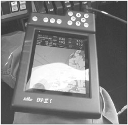
The EKPIV display plays a video trick, allowing the user to view data in landscape or portrait mode. This allows flexibility for mounting and some owners get creative and mount it right on the instrument panel, teasing the FAA with a half-portable/half-permanent installation. We like the map detail in all that screen area. Frankly, it puts many panel mounted MFDs to shame.It has an amazingly quick processor, too, running at 226 MHz. GPS engine performance with the IIIC and IV is flawless, with quick lock-on and no noticeable drop-out of signal, with the remote amplified antenna.
We still think that these products get half the attention that they deserve and buyers who opt for them get durable devices with excellent displays and straightforward operating logic. They arent good personal navigators, however, the sort you toss in your backpack on hiking trips.Theyre even big in the car, frankly. But if thats what you want, the EKP series delivers.
Recommendations
Lowrance, in our view, offers the most utility, gee-whiz features and pro-pilot design at a price point thats, well, cheap, no matter which model you pick. The flagship 2000C is the best value in the line, in our view, mainly due to its sharp color, complete accessories package and surface diagrams.
If you want to toss a small unit into the flightbag for back-up and want it to double as a personal navigator worthy of road trips and outdoor adventure, top choice is the Garmin GPS96C. It has a nice display, capable ground nav and runs forever on a set of batteries.
The best of the best, if price isn’t a factor? Thats easy: Garmin 296. It has capabilities to rival a full-up PFD. Connect it to ships power and an external antenna and you have avionics that can do everything but talk. (Well, it does that, too, in ground mapping mode.)
The AvMap EKPIIIC is a worthy product but also a specialized one. Its best suited for utility, helicopter and law enforcement/survey work, where a large, detailed map is a must. Terrific as that display is, it will simply be too large for most general aviation users.
Also With This Article
“Checklist”
“Portable GPS Specs Compared”
“Ground Navigation: Garmin is King”
-Larry Anglisano is Aviation Consumers avionics editor.