In the short space of a couple of years, it seems, the GPS mapcomm has become standard equipment in most aircraft. Yet fewer than half the aircraft flying have this equipment and many that do are still sporting portable GPS units as back-up gear.
That means there’s still a lively-if not red hot-market for portable GPS and still good reason to own one or upgrade an older one. Were often surprised when an owner, having just paid for a big bucks panel-mount GPS, will ask about the best portable for back-up purposes.
And, of course, the vast majority of aircraft owners still don’t have IFR GPS of any kind, preferring instead to make do with an older VFR panel mount or a high-end portable. In our view, there’s nothing wrong with that. Frankly, the top-end portables do nearly as much as panel mounts, at a fraction of the cost.
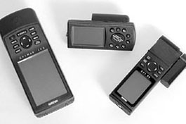
With these considerations in mind, heres a survey of the current portable market. Weve included all of the major players except two: The Apollo Precedus and the Skyforce/Skymap units from Bendix/King/Honeywell. Although the Precedus is occasionally seen in Trade-A-Plane ads, its no longer actively marketed and the Skyforce units are not true portables, since they lack a battery option.
What You Want
What to look for in a portable? Ignoring price for the moment, we think ease of operation, display readability, GPS engine performance, mounting flexibility and accessories are the driving considerations. You can then decide what level of feature performance your budget will buy. If you invert this criteria and put price at the top, you’ll have to give up something, most likely accessories such as external antennas, carrying cases, mounting brackets and so on. As the portable GPS market has matured, it has, by natural selection, sorted itself into navigators suitable for primary navigation and less expensive units perfect for living in the flightbag as rainy day back-up.
Garmins World
Some Garmin portables have a subdued globe logo embossed into the outer case. If Garmin included the phrase, we own this under the globe, no one would accuse them of exaggerating.
With few fumbles, Garmin has risen to dominate the aviation portable GPS market, beginning with the impressive GPS 100 nearly a decade ago. In the current market, the company has four offerings at price points across the map.
Garmins first big megahit in the portable market was the diminutive GPS 90, with a single-channel engine and a tiny moving map. Reworked and re-engined with a PhaseTrac 12-channel and 100X64 pixel LCD display, the GPS 92 represents the low-end of the Garmin portable line.
Although we loved the GPS 90 for its small size, generous database and ease of use, the GPS 92 is a tough sell and not high value, in our estimation. While the 12-channel receiver leaves the old single-channel multi-plexer in the dust, the 92 is still stuck with a small screen and a basic database. But compared to other Garmin offerings, the map is sparse, at best, and its backlighting is adequate if not spectacular. On the plus side, the 92 can run up to 20 hours on a set of four AA alkalines, which is important for a back-up device. For the asking price of about $500 on the street, you get a remote antenna mount and a power/data cable for hardwiring but no yoke mount. If it existed in a void, the GPS 92 would be a hot deal. But it doesnt. The 92 is outclassed by Garmins own offerings and even though all are more expensive, they represent better value.
GPS III Pilot
Among those better values is the GPS III Pilot, one of Garmins more recent designs and a navigator that evolved from recreational and marine units. Like the GPS 92, the GPS III Pilot has Garmins 12-channel chip, which can suck position data through a concrete wall. (Well, almost.) We like the stub antenna, which pivots vertically and disconnects easily for remote mounting via a standard BNC jack. The GPS IIIs trick of displaying nav info vertically or horizontally convinces many buyers to opt for it over the larger 195 or color 295.
Yoke mounting is not a standard offering but the GPS IIIs triangular cross-section lends itself to Velcro glareshield mounting, which puts it nicely at eye level. Like the 92, it suffers somewhat from small screen size; 2.25 X 1.5 inches is not huge for the presbyopic set. You can improve viewability by installing the navigator in the optional yoke mount, which brings it closer to the eyes. If you rent or fly different airplanes, use the beanbag mount, which is simply a weighted bag that holds the receiver firmly on the glareshield.
Thanks to the units small size (2 3/8 X 5X 1 3/8 inches) it leaves room for an approach plate when yoke mounted. And its light enough to even Velcro atop the yoke in the horizontal position.
The GPS III pilot has a well-detailed base map (absent from the GPS92) that includes highways, lakes, rivers, coastlines and state boundaries. The Jeppesen database covers airports, VORs, intersections, NDBs, airspace, frequencies and runway data.
The basic pages include an HSI, map page (which can be viewed with datafields or without), flightplan page, satellite status page and a numerical nav data field. All pages can be easily customized to suit the user.
Logic wise, the GPS III Pilot is about as simple as it gets. The menu system is driven by a rocker keypad and is intuitive enough to allow stepping through the various functions without reference to the manual. In our onboard trials, navigation reliability has always been solid, even without remotely mounting the portable antenna to the windscreen. Initial lock on, even when moving, is quick. Some aircraft with heated windshields or small windows might require remote mounting of the antenna, which solves signal problems.
Battery life is good to excellent. We generally see 10 to 15 hours from four AA alkalines but far less if the backlighting is used. Best case is to plug it into the cigarette lighter-the cable is an option-or have it hardwired. At $600 street price, the GPS III Pilot is a no-brainer against the sparsely featured GPS 92.
GPS 195
When the GPS 195 hit the market, it drew gasps with its large screen and map detail. But Lowrance took some of the shine off that apple by beating Garmin to the market with its 300 Airmap by six months.
The 195s screen measures 3 X 7 X 2 inches but the unit itself is large and somewhat heavy at 23 ounces. The only reasonable mounting scheme for the 195 is on the yoke or sitting on an unused right seat. (Yoke mount is standard.)
Six AA alkalines power the unit for about 10 hours, sans backlighting. But the best bet is to feed it aircraft power through the standard lighter cable plug or through hardwiring. A NiCAD pack is an option but our tests have proven that this isn’t the best idea, due to unpredictable discharge and charging patterns.The 195 was the first Garmin portable with approaches in the database. These are probably abused more often than not, but we think its a good back-up emergency feature and excellent for monitoring VOR or NDB approaches. You wont see all of the approach waypoints, just the FAF and MAP. you’ll also see ILS fixes. We find the approaches a tad awkward to access but with practice, they can be mastered. Operating logic: Again, dead easy. Five pages of functions are accessed by pressing the page key, which brings up a sat acquisition page, HSI page, route page, map page and numerical nav page.
Datafields are also displayed on the HSI page and are customizable. Many users toggle between the map and HSI page, while others use only one or the other. The 195 also provides vertical guidance that allows you to set up a descent profile.
One beef weve always had about the 195 is the time it takes the map page to refresh when changing map scales. Still, the display is crisp and the adjustable backlighting is effective at night. If your vision is fuzzy, you can adjust the display type size.
Standard accessories include yoke mount, cigar lighter adapter and a remote mount antenna-the 195s primary antenna is an onboard affair located at the top front of the unit. As with the GPS III Pilot, an external patch antenna will be required in some airplanes, but rarely.
The standard remote connects to the unit via a small connector that at first appears fragile but seems to stand up to abuse, nonetheless. We would prefer the standard BNC connector found on the 92 and GPS III Pilot, however.
With its recent reduction in price to about $950 on the street, the GPS Map 195 represents one of the best values in the current market. It has a decent database, a strong GPS engine and a large screen. Valuewise, its competitive with anything out there.
Garmin GPS 295
Weighing in like an inflated GPS III Pilot is the GPS 295, Garmins first aviation portable in living color. As we reported when the 295 debuted, we didnt think a battery operated color portable was doable, but Garmin proved us wrong.
The 295 is not a colorized 195 but a clean sheet design with a different operating system and a stunning color display rivaling Garmins panel-mount products. Overall size is 6 3/4 X 3 1/4 X 2 1/4 inches with a generous screen size of 1 X 3 3/8 inches and a weight of 19 ounces.
We think the best mounting option is the yoke mount and, a big improvement, is the way the cigar lighter adapter plugs into the unit. It doesnt interface with the mount but plugs directly into the back of the GPS. Thats one weakness of the 195; the yoke mount ties the power/data cable together in a Frankenstein-like arrangement only an MIT engineering dropout could love.
Battery life in the 295-six AAs-is short, but at least it has them as back-up. That power thirsty color display will waste a set of batteries in under three hours.
From the price/value point of view, the GPS 295 is the top strata, delivered complete with a bag full of stuff including yoke mount, power adapter, remote antenna-the same post style used with the GPS GPS III and GPS92-and a vehicle mount for the dashboard. Also standard is the PC interface kit for loading databases or interfacing with the Metroguide Map Source software, which is Garmins ground navigation offering.
Add the Mapsource data (loaded via an 8 MB or 16 MB cartridge) and you have everything you need for taking the GPS295 on a roadtrip. We use Garmins Street Pilot, which is the auto version of the 295, and find it quite effective. With street-level detail of towns, points of interest such as entertainment, service areas, ATM machines and such, you’ll never get lost again. That said, as we reported in the June 2000 issue of Aviation Consumer, were not sure having the option of both air and ground navigation in the same unit is worth the hassle of the data loading. The GPS 295 has a quicker processor than the 195 and the long map redraw time has also been addressed. The eight-color display can be put into night mode, switching the yellow basemap to black and you can easily adjust contrast and brightness through the power key.
We didnt think that the color display would be as helpful as it really is until we used it, particularly for basemap operation. There’s never any doubt where there’s water-its blue-highways, which are red and land, yellow. Accessing waypoints is less time consuming compared to the 195 or III Pilot. You do less typing and more selecting from the available menus, although searching for addresses is a bit cumbersome. But since most will use the 295 in the air and not looking for street addresses, this is not a significant drawback.
We like the option of having the HSI displayed on the map page. You lose some of the map, obviously, but it beats toggling back and forth from page to page while flying. And, of course, you can turn the HSI off and run the full-page map instead.
The 295 has approaches and even includes vectors to final, as found in Garmins IFR boxes. The logic is so similar to the panel mounts that if you can operate a 430, you can operate a 295 and vice versa. Like the 195, the approaches are for monitoring only and don’t include the same type of waypoint sequencing and display found in the panel mounts.
Like the III Pilot and 195, the 295 can be interfaced with most of the Garmin line of panel mounts via the power/data cable. The benefit? If you have a mono navigator, approach approved or not, the power/data interface allows downloading of nav info onto the portables screen. This provides a detailed map presentation while adding the redundancy of a battery operated portable.
At about $1450 street price, the 295 is Garmins flagship portable and, no surprise, weve found that some owners are using it as a stopgap navigator while waiting for better or at least lower-priced color panel mounts. Not a bad strategy, even if those cheap panel mounts arent on the horizon, presently.
Lowrance Airmaps
Lowrance is somewhat of a legend in marine electronics but broke into aviation portables with the Airmap 300, a credible product with a 12-channel Rockwell chip that was-and is-an excellent performer. The Airmap 300 is medium in size, measuring 3.6 X 5.6 X 1.8 inches. It beat the Garmin 195 to market with the first portable map with ground detail, such as lakes, rivers and roads.
The 300s power source is six AA alkalines and you get an NiMH rechargeable pack as well. The display is high contrast, SuperTwist LCD with adjustable backlighting which is quite sharp, rendering nice ground detail with an adequate although hardly blistering refresh rate.
Like Garmins mid- to high-end products, the 300 comes standard with yoke mount, cigar lighter adapter and a case. The Lowrance yoke mounts are the best weve seen in ease of use and design, if not construction. However, we don’t care for how Lowrance interfaces the power and antenna cable. Flimsy plastic covers that don’t give a sturdy feel cover the ports. Garmin definitely wins in this area, even with the clunky yoke mount for the 195.