Synthetic Vision: VistaNav Rule

Mercurys VistaNav stands alone as the only workable, gyro-based turnkey option. But MountainScope has useful features at lower cost.

The glass panel revolution hasnt happened yet. The big leap is to synthetic vision, where blue over orange is replaced with a topographic terrain in 3D perspective and navigation is by some kind of highway-in-the-sky (HITS) guidance. The only company to make this leap in a certified system so far is Chelton. For the 99 percent of us who cant invest $100,000 in a full-panel overhaul, however, there are some portable options for under $5000.

They require their own display-a laptop computer or EFB-type tablet-plus hardware that will tell the aircraft not only where it is in space, but also its bank angle, pitch and velocity. Systems that rely entirely on GPS information can intuit much of this, but they dont know if an aircraft is right-side up. Theyd happily

Chuck Burkhead

288

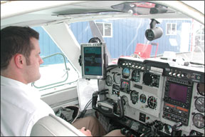
draw the world as level even if the aircraft was halfway through a snap roll.

If we limit the discussion to portable systems that have some type of attitude gyro driving their 3D display, only two primary competitors remain: VistaNav from Mercury Computing Systems and MountainScope from PCAvionics. Soon, Flight Cheetah from Echoflight will combine their attitude information with their 3D display, but as we go to press with this report, that software is still in beta.

The View from A Vista

“What I often tell people when theyre first getting started is to not even load anything,” says Jeff Simon, product manager for VistaNav. “Just fly with it in synthetic-vision view so you get that VFR view out the window.” Enhanced situational awareness is the number-one plus of synthetic vision. You might see nothing but grey mist or the black of night on an approach to an airport, but on the little screen you see a runway, hillsides and obstructions, all in three dimensions. Turn on the terrain warning (TAWS) feature and terrain safely below you is colored green, the dirt and rocks within 1000 feet of your wheels is yellow and stuff higher than you is red. Thats based on your current altitude, but a forward-looking TAWS that would predict a conflict is in the works.

In the 3D view, airports, NAVAIDs and intersections appear as flags in the virtual sky pointing down to the ground. Its intuitive, but can get cluttered. VistaNav has extensive configuration options to turn on and off what you see and when you see it. A whole set of options can be saved as one of four views. A set of onscreen buttons running down the left of the display lets you quickly toggle what you need to see for different circumstances. Theres also a 2D view, which is a standard moving map display. The display most users fly with in the real world is a split-screen with 3D on top and the moving map on the bottom. We found the interface straightforward and intuitive. Tap an airport in either view and you get a popup with airport information (including weather if you have the optional XM

VistaNav’s Electronic Gyro Package

288

Radio/WxWorx tied into the system). Detailed information about any airport, including plates, can be opened full screen.

Enter a flight plan into VistaNav and youll get another layer of information on the screen. The 2D view gets a magenta line, but the 3D view gets a magenta road. The road appears floating in the virtual air at the nearest 500-foot altitude to where you activated the flight plan. Climb 100 feet off this altitude and youll clearly see youre flying above the road. Climb 400 feet, though, and the road will “jump” up and youll be 100 feet below it.

VistaNav doesnt use a fly-through-the-boxes system. The aerial road is flat. Hovering in front of you is a pink square youll never catch. Its a nine-second target box-where you should be nine seconds from now. Theres also a nine-second flight-path predictor, which is a white circle with three lines reminiscent of wings and a tail. Keep the predictor inside the target and youll stay on course. The power of the HITS guidance comes with instrument approaches. Theres a PROC button that lets you select and load an approach. Activate the approach and get HITS guidance to intercept the final approach course just outside the final approach fix (FAF). Once on the approach, youll get guidance from the FAF to the decision height (DH) or missed approach point (MAP).

“With synthetic vision you are, by default, ahead of the aircraft because you see the drift, you see the turn coming up,” said Simon. Hes right. Its hard to appreciate until youve flown it. You just join the magenta road and follow it as it turns and heads downhill. At the end of the road is a realistic depiction of the runway. Waypoints are labeled as boxes you fly though, including a huge “DH” or “MAP” that floats in space and would be hard to miss with the screen in your scan.

Its so easy to follow, in fact, that you hardly notice youre heading downhill. We got so wrapped up in the game of following the path that we actually forgot to do some necessary power management on the Bonanza we were flying. Of course, its just supplemental. You should really be flying the needles on your panel.

But part of the appeal of these systems is for emergencies. We did unusual attitude recoveries under the hood and flew vectors to an ILS using nothing but

Poor Flying Conditions

288

the VistaNav display. Theres no question that you could get down safely using only this system once you had some practice using it. On that note, VistaNav has the simplest and cleverest simulator controls weve seen so far.

Like any GPS navigator, VistaNav has a nearest airport feature. It also has an E-Glide feature for HITS guidance to that airport, based on the glide performance of your aircraft. Of course, youd have to enter that data before the engine tanked in the soup. The only big wart, in our opinion, is that if you want to call up information about an airport or load an approach, you lose the 3D view. So if you have full failure of your G1000 – as actually happened to one VistaNav user in broken IMC-you give up synthetic vision whenever you use the system for basic airport or approach reference.

Bright Hardware Idea

The base VistaNav system, called the CIS 1000, runs on a Motion LS800 TabletPC and costs between $4299 and $4899. The pricier systems have solid state, not conventional flying head disc drives, so they wont crash at high altitude. Included is a combined WAAS GPS, barometric pressure sensor and inertial navigation system with digital gyros, all in one box called the INU.

Mercury builds this box themselves using technology from their work on GlobalHawk and Predator UAV components. There are no wires except power, as the box communicates with the tablet via wireless Bluetooth. WxWorx weather comes from

VistaNav’s Synthetic View

288

a separate wireless receiver. The unit also can display traffic from the Zaon XRX traffic minder in both 2D and 3D views.

The tablet itself is the weakest link in this chain. It can be hard to read in some light, the pen interface is problematic in turbulence and it can only put out about 10 frames per second (FPS) in 3D view. It also requires a special pen to push on-screen buttons. Touch-sensitive screens are notoriously poor optically.

Failing to find anything on the market better than the LS800, Mercury decided to build their own. The CIS 2000 VistaNav system puts the computer in the same box as the INU and connects to the screen with a cable. The screen is touch sensitive, but uses an optically-beautiful capacitance technology. Its nearly twice as bright as the Motion and dedicated buttons across the bottom and two nested rotary knobs (think Garmin 430) are used for moving a cursor around and entering information. You can use touch, the knobs and buttons, or both to control the software.

The CIS 2000 displays 3D at 30 fps. It will be available soon at $5999 for the hard drive version and $6799 for the solid-state version. Mounting equipment, traffic and XM cost extra. VistaNav sells navigation data, including obstructions, airport information, current NACO approach plates, airport diagrams, and all VistaNav software updates for $199 per year. The system checks for information currency at startup and can be updated via the internet if its removed from the aircraft. Future revisions will offer Jeppesen plates for an additional subscription fee.

The system isnt all roses. We saw two bugs on test flights, including an approach that wouldnt activate correctly. Wed like to see all the approach fixes rather than just the FAF and a VFR runway centerline extension. Also, not all U.S. approaches are available yet. But Mercury is working to improve the product and customers are happy with the level of support.

Simple Can Be Good

Where the VistaNav INU is the size of the seventh Harry Potter novel, MountainScope sells the PC Flight Systems eGyro, which is the size of a pack of playing cards. Flight Cheetah uses the same gyro. VistaNav sells the hardware and software only as a combined unit, where MountainScope suggests using the LS800, but sells the software to run on anything from a PocketPC to a laptop. We tested MountainScope on the LS800 to be as fair as possible.

The software is simpler than VistaNav, with no approaches. But it does have the same 2D/3D split view thats quite comfortable to fly. Its TAWS works well and the program displays nicely. It actually gives more information at a glance than VistaNav for nearest items and it adds nearest VORs and intuitive arrows for direction. It has airport information available by tapping in the 2D view. We found MountainScopes landscape more detailed than VistaNavs.

MountainScope doesnt show a true HITS view because it doesnt show altitude. Instead, theres a grey, semi-opaque path for the course set in the flight plan. Its easy to follow. The system is controlled through a set of menus thats more cumbersome than VistaNavs on-screen buttons, but you actually rarely need the menu in flight. Like VistaNav, its highly configurable. Not only does it have a sim mode for training, but it can take input from Microsoft Flight Simulator for practice flying. A big plus for MountainScope was that the 3D view can remain visible while displaying airport information, although you have to resize a window to see both the 3D view and an approach plate. Since it doesnt have built-in approaches, we did the best we could using a GPS approach on paper and distances and bearings to the airport. With the virtual runway so visible and terrain clearly shown, we felt we could make it down alive using nothing but the MountainScope display.

MountainScopes simpler gyro and lack of baro information makes for a choppy display during radical changes in pitch or bank, but we were able to recover from unusual attitudes using only the display. MountainScope can display XM-based weather, as well as ADS-B information if connected to the right hardware. For homebuilders, MountainScope can integrate with some autopilots and take Dynon and Crossbow gyro info and also tie into a pitot-static system.

The MountainScope software sells for $495, but a complete system with LS800, eGyro and GPS would cost around $3500, depending on how many wires you replace with wireless connections. Updates to plates and obstructions are downloaded from the Website for $15 per download, with the first six free.

A New Class of Glass

Jeff Simon noted that many of the 300+ VistaNav systems flying were in glass-panel aircraft. This speaks volumes. Having a 3D view is completely different from having digital PFD displays. The important thing is to think about what you want from that view. If its just improved situational awareness, even a GPS-only system will work. Check out Chart Case for an excellent program that has a simple 3D view of the terrain ahead.

If youre looking for something that will warn you of impending unusual attitudes or provide guidance in an emergency, you need gyro input. MountainScope can save you significant bucks depending on your equipment needs. If youre looking for a serious, 3D navigation display that augments your panel instruments right now, theres only one player: VistaNav.

Jeff Van West is a CFII and editor of Aviation Consumers sister magazine, IFR.