











by Larry Anglisano and
Paul Bertorelli
Wouldnt it be nice to have a fast, cheap and reliable datalink system that you could slap into your airplane so you could fly around during thunderstorm season without scaring the bejesus out of yourself and your passengers? Sure it would.
Our advice is to pick two of those adjectives and write the check because fast, cheap and reliable isn’t quite here yet. When we last reported on aviation datalink in the September, 2002 issue, the market was awash in choices but also fraught with uncertainty about who would deliver what and when.
There are still at least 10 datalink avenues to chose from-not all of them dedicated weather datalink-including two that recently debuted and which we’ll examine in this report. And as we go to press, Bendix/King is set to announce a lower-cost datalink system based on its economy KMD250 display. we’ll have more on that later. Further, within the next year, we expect more shakeouts and at least some vendors believe there will be economy choices in monthly fees for occasional datalink users.
WxWorx/XMRadio
At EAAs AirVenture show a year ago, we saw an intriguing datalink proposal from a company called WxWorx to broadcast weather data using the XM Radio satellite broadcast system. If that idea was a trial balloon, it apparently has legs; WxWorx is selling a portable datalink system to display on laptops and PDAs and will soon offer a certified system.
Who are these guys? WxWorx is a spin off of Baron Services, which provides Doppler radar hardware and weather data products to the commercial television market. It has developed its own hardware for a portable datalink system using XM Radio and a third company, Heads-Up Technology, has designed and will build a certified system, one for data only and a second dual-channel unit for weather and entertainment.
XM Radio has a couple of geostationary satellites parked over the U.S. and has eked out a market for subscription-based radio broadcasts. WxWorx represents XM Radios first foray into data transmission, something the company told us it always had plans to do. Aviation is likely to be the smallest market for data but if its successful, marine and terrestrial data may be XMs bread and butter in the datalink market.
Unlike the low-earth-orbit Orbcomm system, XMs two satellites-appropriately called Rock and Roll-are high power and relatively high bandwidth, although not as high as the ground-based Bendix/King system. Further, XM is true broadcast; a one-way system from the satellite to the ground, not request/reply, as is Orbcomm.
As with WSI, WxWorx provides its own weather products by enhancing NEXRAD and other government data. Subscription fees are $49 a month for all the data you want. (The broadcast is continuously updated automatically, whether the weather is viewed or not.)
The portable version of WxWorxs system consists of a receiver about the size and shape of a fat portable CD player, a GPS-style puck antenna and software to run on a Windows laptop computer. The complete portable system costs $829.97, to include the receiver and antenna, Windows-based software and a GPS interface. The antenna can be mounted externally on the roof of the aircraft or simply placed on the glareshield, according to WxWorx. We werent able to test the system in a moving aircraft but tried it on the ground, with the antenna placed outside the building. It appeared to have no trouble acquiring a strong signal.
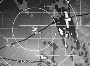
As shown in the photos, WxWorx is a simple, menu-driven system that requires little instruction to operate. It initially shows a map of the U.S. and by clicking on the radar button, any available NEXRAD is depicted in the standard VIP colors. You can zoom in on the area with a cursor lasso and examine such details as direction of movement and cloud top information. The system depicts a small aircraft symbol on the map, based on independently supplied GPS position data.
For additional detail, WxWorx has something it calls a SCIT for storm center identification tracking. This feature pops up a detailed textual summary of rainfall rates, hail, movement and tops in the most intense part of the storm. You can also toggle on or off icons for VORs, airways and airports. Similarly, there are buttons for lightning strike data, winds aloft at various altitudes and real-time TFR plotting.
The system continually refreshes as new data becomes available and from what we could tell, the NEXRAD imagery showed little or no latency. The NEXRAD image itself is issued on a base cycle of 5 minutes. On an active weather day in Florida, all of the requests we asked for were delivered in under a minute, which is sufficient timeliness for conservative penetration of weak lines or scattered cells.
On a laptop, the WxWorx system is childs play to use but the downside is the usual nuisance of wires, connectors and the bulk of a notebook in the cockpit. Also, you’ll need a laptop with some processing horsepower to get the most out of this system. In the past, weve never found a notebook to be desirable in the cockpit. But if youre desperate for weather, the WxWorx system might be worth the hassle.
Two things we don’t yet know: which panel-mount displays will this system work with and how will the interface operate? We like that zoom-in option. You can eyeball weather 400 miles away on course then zoom to see how bad it is. But can that be made to work on, say, a Garmin 530? Second, the Garmin/Echo Flight system has proven to be tender; stray electrical noise in the airplane can wreak havoc with it. We don’t know if the same will be true of the XM Radio-based datalink but we suspect it will be more robust, given XMs broadcast performance.
In our estimation, the future of this system is the dual-channel receiver, one that does datalink and audio entertainment. WxWorx says that will be an eventual option. For now, the certified receiver is supposed to be available later this year for a price of $3750, including antenna.
WSI InFlight
Datalink weather for the UPSAT (now Garmin AT) MX20 comes later than anticipated for a few reasons. First, the initial product interface was to be the Satellink/Merlin, which came on strong a year ago but seems to have all but disappeared, due in part to delays by the FAA. WSI, a pioneer and proven serious player in the weather information industry, seems a more reliable source, although it has limited experience in onboard aircraft systems.
As the Merlin project dragged, UPSAT had to go back to the software drawing board and rework the interface with WSI. WSI has two products, the non-certified AV100 ($3495) is categorized as a portable system and it plays on EFBs and laptops. The certified system is called the AV200 ($4995) and is made for WSI by Sandia Aerospace. It now has PMA approval and as we go to press, there’s one STC applicable to the Piper PA-32 series. All other installations have to be FAA field approved and frankly, we think this could be a problem for WSI.
Many FSDOs are making it as difficult as possible for shops to install anything under field approval rules. These early interfaces-FAA approval guinea pigs, if you will-could we’ll have avionics shops and customers wondering what they got themselves into. In our view, companies such as Garmin and Avidyne have a leg up on WSI because theyre more experienced in helping shops overcome difficult installation hurdles, both technical and bureaucratic. Were told that by signing off weather, traffic and terrain systems, the FAA believes its taking on legal liability and that sooner or later, a pilot will make a smoking hole and lawyers will have a field day. Whether this is an accurate assessment is difficult to say but owners are increasingly shopping FSDOs to find a cooperative fed.
FAA shenanigans aside, WSIs AV200 has several good things going for it that may make future approvals increasingly easier. Its a simple system mechanically and electronically and it fits right in with the MX20s long list of external inputs. While we have limited experience flying the WSI system, we can say that the reliability of the streamed weather data was apparent from initial system power-up. Once we had it configured, we never had an interruption of the datastream, even while the aircraft was positioned close to hangars.
The AV200 receiver is a lightweight (less than 1 pound) remote box measuring 9 X 2.3 X .75 inches and it mounts anywhere there’s space, usually in the tail. We like the antenna, a familiar GPS-style teardrop design made by Comant. In most cases, its design eliminates the need for the shop to play musical antennas, relocating existing antennas to ensure the performance of the weather system.
However, the antenna should be located as horizontally as possible- not exceeding 5 degrees of pitch-to avoid performance degradation. Unlike competing products using the Orbcomm network and systems using ground-based transmitters, the design of the AV200s antenna is easy to accommodate and this means less installation cost and shorter down times.
The receiver is connected to the display via RS232 protocol. As we go to press, the only panel-mounted MFD it interfaces with is the UPSAT/GarminAT MX20, software version 5.0 or higher.