by Paul Bertorelli
Flying around-and occasionally through-convective weather with no radar or sferics gadgets is really no big deal. Just try to suck the seat cushion up with your sphincter muscle and the angst and fear will melt away like a campaign promise in December. In the days before Stormscopes and airborne radar, many of us actually thought this way because some grizzled old geezer said so or, more realistically, we had no choice.
Datalink NEXRAD to the cockpit is changing that, of course, and its just now getting better, cheaper and easier to get. When we last examined this topic barely a year ago, we predicted a shakeout in the datalink field and it appears that this is happening, or soon will. If there’s a brave new world of datalink weather, its about to be ruled by XM Radio and, perhaps, WSI with its InFlight weather data system. Its not that other systems arent worth considering, but WxWorxs and WSIs geo-sync-based data feeds have proven far more robust than anything else and with monthly rates about to decline and new, smaller portable displays becoming available, datalink weather may soon become too affordable to resist.
To further distill the fine-point capabilities of what we consider to be the top two systems, we recently conducted flight trials in an airplane equipped with five weather systems-yes, really-WSI Inflight, Avidynes datalink, the XM-based WxWorx, a WX-1000E Stormscope and an RDR160 airborne weather radar. More details on that later, but first some new developments.
New Stuff, Prices
When datalink first appeared, one worry for the companies providing it was market size: would enough customers pay a monthly nut to make a business of datalink and what would the monthly nut be? That question remains unanswered but at EAA AirVenture in July, WxWorx/XM Radio planned to unveil a new monthly pricing plan providing NEXRAD, TFRs and METARs for $29.95 a month, $20 less than the current $49.95 plan. In our view, this is a significant price break thats likely to expand the market in XMs favor and place competitive pressure on other providers for lower prices. As noted, the shakeout is underway.
Further, new receiver and display hardware is soon to be available. In the panel-mount realm, Garmins XM-based GDL69 datalink receiver will be available this fall but, alas, only for the upper crust G1000 primary flight display system. For those of us slumming along with GNS530s, Garmin refuses to commit publicly to an XM data option. But given the lackluster performance of the Orbcomm-based GDL49 datalink receiver, Garmin is certain to follow-up with a better product. There are many thousands of GNS430/530 owners out there who will buy good performing datalink at the right price. Call us Pollyannas, but we don’t think Garmin will walk away from that business. Prediction: look for an announcement later this year or early next.
As we go to press, Avidyne announced that its now offering an XM-based receiver priced at $3750, including antenna. This receiver is now being certified by Heads-Up Technologies, the same company developing the WxWorx certified receiver. Avidyne says it will use the EX500s current interface/software and that users will have the option of switching from XM to Orbcomm, so the latter can serve as a back-up. The Orbcomm receiver is integrated into the EX500 while the XM receiver will be a separate box.
In the portable realm, Control Vision, the scrappy company that has made a name for itself in PDA-based navigation, charting and flight instrument products, recently announced that it has joined the XM bandwagon by adapting the WxWorx data protocol to run on an iPAQ 5500 PDA.
Control Vision already had its own weather datalink product based on the Globalstar satellite phone system, offering the benefits of an airborne phone (and e-mail) but data transmission less elegant than the XM model. As we go press, Control Vision was about to announce a new display device called a Raven thats larger than a PDA but smaller than a tablet computer. we’ll have more details on that in the coming months.
In the Air
First, some numbers. WSI Inflight is available in two versions: the non-certified AV100 receiver sells for $3495 and plays on tablets and laptops; its considered a portable installation. The certified AV200 sells for $4995 and outputs to the Garmin AT MX20 MFD with other MFDs planned.
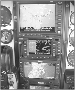
For now, the WxWorx XM Radio receiver is a portable only and is sold in two bundles. The basic bundle costs $679.98 and includes only the receiver, software and weather functions; a premium bundle sells for $929.99 and adds GPS functionality, which we think is a must. Avidynes Orbcomm-based datalink is standard equipment with the EX500 MFD; it lists for $8995 for a non-airborne radar version and varies between $9995 and $14,995, depending on the radar front-end type. Monthly charges for the data are shown above. Weve flown or tried each system individually but never together. The opportunity for an informal flyoff came from Richard Hardoon, an Orlando-based Baron owner who has both the WSI and Avidyne systems in his airplane. He installed the EX500 to replace a monochrome display for a Bendix RDR160 radar. To round out his flying weather lab, Hardoon has a WX-1000E Stormscope. For our flight trials, we brought along the WxWorx portable system running on a Compaq notebook.
We departed Orlando Executive and flew north, into an area where NEXRAD showed an active line of storms on a northeast to southwest axis from the Daytona Beach area to near the west coast of Florida. Upon start-up, we set the MX20 in weather mode-split screen, with weather on one side, nav on the other-and before we reached the runway for takeoff, we had three-minute old NEXRAD imagery showing the storm area. The Avidyne was still crunching the request and displayed no weather prior to takeoff. For safetys sake, we delayed setting up the laptop until leveling in cruise at 3000 feet.
Getting the WxWorx running is easy but be forewarned, you’ll have to circumnavigate a rats nest of wiring, including a power lead for the receiver, a USB cable to the computer and antenna leads for the receiver and the GPS. If all of this sounds like a pain in the butt, it is. With some tie wraps and Velcro, the wiring can be made tolerable but what makes it worth it is how we’ll WxWorx performs.
Within about four minutes of firing up the laptop, we had a fresh NEXRAD picture of the line we were approaching and could now visually see as an ominous dark area ahead with visible rain shafts. The Avidyne still hadnt produced any weather data at this point and although both WxWorx and WSI painted the line in great detail, the detail in the pictures didnt agree.
We attribute this to different methods used to mosaic the weather data from multiple NEXRAD sites or to timing issues. Another interesting thing we noticed is that at one point, the WSI data placed our position inside a thin part of the line while the WxWorx had us accurately several miles south of it. (The photos in the “Same Storm, Four Views” sidebar, taken within a minute of each other, show this.)
We contacted both WSI and WxWorx to ask about these anomalies and neither was able to provide an explanation. However, we consider these differences relatively unimportant, given the way we think this data should be used to circumnavigate storms, which is with the understanding that there’s definite latency in whats displayed and whats actually happening.
When the Avidyne finally delivered a NEXRAD image-about 20 minutes after takeoff-it varied substantially from what the other two systems showed and what we saw out the window. The Avidyne seemed to show weather worse than it actually was. Throughout our flight, the WSI and WxWorx images were never more than five minutes old.
Easy Workload
All three systems are easy to operate, in our view. The panel mounts are both menu/key driven and you can select either radar imagery or text weather, from tables or menus. Once selected, the imagery automatically updates.
The Avidyne system, being request/reply and priced on a per-use basis, allows a degree of customization for request frequency, coverage area and weather products. Or it can be switched off entirely. The WSI and WxWorx are broadcast systems; you simply sip from the continuous datastream whenever you want it, for a flat fee. Both of the panel-mount systems allow zooming in on the weather area, which is sometimes helpful, sometimes not. In Hardoons airplane, the Avidyne system also offered the option of toggling to airborne weather radar mode once we got close enough to the storm to get serious about finding a hole; this switchover is done with a button stroke so its practical to go from one mode to the other.
Being Windows-based, the WxWorx software works like any other desktop or laptop program, meaning it requires mouse or keyboard manipulation but almost entirely mouse work or, on our Compaq, touchpad control. When it launches and captures the initial data, a map of the entire U.S. appears. You can then zoom in and enlarge the area you want and toggle on or off such details as radar, winds at various altitudes, map details (airways, airports, VORs) and so forth. All this can be done with the mouse and, although hardly convenient in a small cockpit, its tolerable.
One thing we like about the WxWorx software is that you can select any part of the country to view weather, then use the mouse function to zero in on that area. With an enhanced GPS map option, its possible to drill right down to the major artery and street level to pinpoint weather and thanks to the computers superior display, the image doesnt become blocky and ill defined. Viewing distant weather is more difficult to do with the WSI system because its weather view is limited to the 250 miles within the aircrafts current position. However, using the MX20s slew capability, you can examine more distant weather, it just it takes a little effort.
The Avidyne software allows customizing weather retrieval along a specified corridor along the planned route and you can tell the system how often you want it to gather the weather for viewing, both for cost control and bandwidth conservation.
Hardoon told us that while the WSI system seems to perk along automatically with reliable five-minute updates, the Avidyne is more unpredictable, sometimes retrieving weather acceptably, sometimes not retrieving it at all. E-mails and phone interviews with other Avidyne readers reveals a similar pattern, although Avidyne insists that 99 percent of its customers are happy.
No Sparks
Of the three systems, only WxWorx includes ground-based lightning data, which is a toggle-on/toggle-off feature. The other two systems can display lightning data from a remote WX-500 Stormscope. Hardoon told us he likes having the WX-1000 available to confirm what he sees on the radar but were not as convinced the Stormscope is a valuable adjunct, whether as a discrete unit or overlayed on the NEXRAD. Case in point are the photos in the “Same Storm, Four Views” sidebar. The best imagery of the storm-and what agreed with the eyeball view out the window-came from the WxWorx display, which showed a narrow, navigable opening in the line in our 10 oclock position, something the Stormscopes profusion of dots simply couldnt resolve on its own.
Pointing the airplane into the gap, Hardoon could easily illuminate the area with onboard radar to confirm it as flyable. But between the NEXRAD and our eyeballs, we could see as much. Although the airplane symbol was misplaced on the WSI display relative to the weather, the same safe avoidance decision could have been reached using its data.
We are thus somewhat skeptical of the advantage of ground-based lightning data. WxWorxs Mick Gosdin told us the National Lightning Detection Network plots only air-to-ground strikes and then only provides four kilometer resolution so in an active storm, the strike symbols line up in neat rows defined by the four km boxes, a level of tidiness that doesnt reflect storm anatomy. The NLDN has better strike data but Gosdin says its too expensive to be economical.
The providers of datalink have expressed some worries that pilots will use this technology to penetrate storms in the same way they penetrate with onboard radar. The concern-not entirely misplaced-is that uplinked NEXRAD lacks the timeliness for front-line tactical weather decisions. NEXRAD radars continuously scan storms and feed data into an ongoing analytical network. The data you see in the cockpit is a point-in-time snapshot of that analysis and portions of the data may be a minute old or five minutes old. There’s also a brief delay in the uplink process, since providers use their own massaging to mosaic data from numerous radar sites.
For that reason, pilots shouldnt play too fast and loose with uplinked NEXRAD. On the other hand, what appears to be happening is that the definition of penetration-or more accurately, avoidance-is changing. With the NEXRAD megaview available, you can see weather 200 miles before you have to deviate and thus you can make a minor course correction to miss it entirely, across half a state if necessary.
If the decision must be made closer in-right after takeoff-it can be. We have noticed that with reliable five-minute NEXRAD updates, weather areas don’t change size and shape much, although they might in the case of a fast moving spring cold front.
During our trial flight in Florida, we were able to make a penetration decision with three-minute old data and even without the benefit of onboard radar and sferics, the NEXRAD found a flyable gap. Had we departed an airport 150 miles from the weather area, we could just have easily flown an end run around either end of the line without getting the windshield wet.
Conclusion
In our view, datalink technology isn’t quite mature yet, but its getting there. The systems we tried for this flight generally worked as claimed, although the Avidyne was a disappointment compared to the others. Having text weather, TFRs and the like available in the cockpit is a nice-to-have, but the big show continues to be NEXRAD imagery, which remains the best reason to invest in datalink.
In this regard, the WSI and WxWorx systems are essentially equivalent, in our estimation. Each processes the weather a bit differently and offers somewhat different weather products. But for NEXRAD, both deliver the images quickly enough for a pilot to make sound avoidance decisions. Both systems appear to be reliable and robust, with no significant gaps in service delivery.
Unfortunately, the same cant be said of the Orbcomm-based Avidyne system, which is why Avidyne has hurriedly announced that its offering an XM satellite option. Although Avidyne tells us most customers are happy with the Orbcomm product, weve heard from enough disappointed buyers to conclude that compared to the other two satellite systems, the Avidyne is neither as fast nor as reliable in retrieving NEXRAD. We think Avidyne leads the industry in value-driven MFDs for radar indicator replacement but until the XM option is available, there are better choices for datalink, namely WSI and the WxWorx portable.
Speaking of the portable, although its a giant nuisance to set up, its performance offsets the hassle and its bargain price makes it the value leader, hands down. WxWorx has brought datalink into the affordability range of a Cessna 172 or Cherokee owner. In a future issue, we’ll examine tablet computers and the wireless technology that promise to reduce the cockpit clutter for portable devices.
We give Avidyne and Garmin credit for trying to improve the Orbcomm technology and we think theyve made progress. Perhaps in the datalink world of the future, there’s a place for a slower, inexpensive system for occasional use or back-up if an XM satellite dies.
On the other hand, we wouldnt mind at all if someone at Garmin just fessed up and conceded that the Orbcomm thing is probably over. Were sure that thousands of GNS 430/530 owners would like a date certain on when XM-based weather will be available and were just as sure many of them will buy it.
Also With This Article
“Checklist”
“Same Storm, Four Views”
“Datalink Options”
“Orbcomm: Down for the Count?”
Contacts
• AirCell, 888-328-0200, www.aircell.com
• Anywhere/Control Vision, 800-292-1160, www.anywheremap.com
• Avidyne Corp., 800-284-3963, www.avidyne.com
• Bendix/King, 877-712-2386, www.bendixking.com
• Blue Sky Network, 858-551-3894, www.blueskynetwork.com
• EchoFlight, 888-948-9657, www.echoflight.com
• Garmin, 800-800-1020, www.garmin.com
• Navair/Airgator, 914-666-5656, www.airgator.com
• Icarus Instruments/Sky Connect, 301-891-0600, www.icarusinstruments.com
• WSI, 800-872-2359, www.wsi.com/
• WxWorx, 321-751-9202, www.wxworx.com